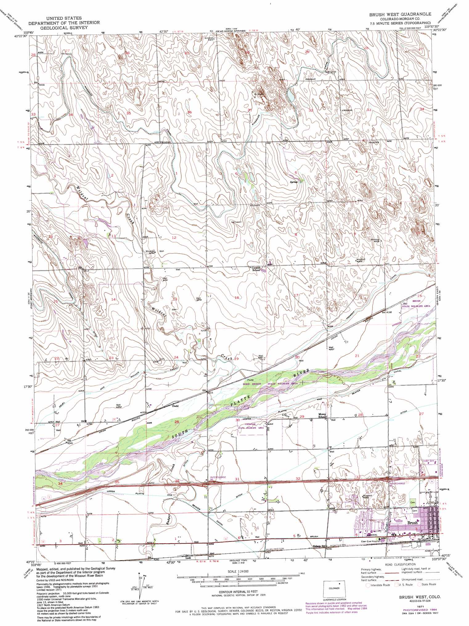
Brush West Topo Map Colorado
To zoom in, hover over the map of Brush West
USGS Topo Quad 40103c6 - 1:24,000 scale
| Topo Map Name: | Brush West |
| USGS Topo Quad ID: | 40103c6 |
| Print Size: | ca. 21 1/4" wide x 27" high |
| Southeast Coordinates: | 40.25° N latitude / 103.625° W longitude |
| Map Center Coordinates: | 40.3125° N latitude / 103.6875° W longitude |
| U.S. State: | CO |
| Filename: | o40103c6.jpg |
| Download Map JPG Image: | Brush West topo map 1:24,000 scale |
| Map Type: | Topographic |
| Topo Series: | 7.5´ |
| Map Scale: | 1:24,000 |
| Source of Map Images: | United States Geological Survey (USGS) |
| Alternate Map Versions: |
Brush West CO 1951, updated 1952 Download PDF Buy paper map Brush West CO 1951, updated 1952 Download PDF Buy paper map Brush West CO 1951, updated 1970 Download PDF Buy paper map Brush West CO 1951, updated 1972 Download PDF Buy paper map Brush West CO 1951, updated 1972 Download PDF Buy paper map Brush West CO 1971, updated 1984 Download PDF Buy paper map Brush West CO 2010 Download PDF Buy paper map Brush West CO 2013 Download PDF Buy paper map Brush West CO 2016 Download PDF Buy paper map |
1:24,000 Topo Quads surrounding Brush West
Buckingham |
Raymer |
Stoneham |
Stoneham Se |
Willard |
Judson Hills |
Peace Valley School |
Dead Horse Springs |
Antelope Springs |
Messex |
Weldona |
Fort Morgan |
Brush West |
Brush East |
Merino Sw |
Vallery |
Lamb |
Round Top |
Miller Ranch |
Pinneo |
Adena |
Vallery Se |
Huey Ranch |
Gary |
Rago |
> Back to 40103a1 at 1:100,000 scale
> Back to 40102a1 at 1:250,000 scale
> Back to U.S. Topo Maps home
Brush West topo map: Gazetteer
Brush West: Airports
Fremont Butte Heliport elevation 1300m 4265′Brush West: Canals
Brush Lateral elevation 1294m 4245′Tremont Canal elevation 1285m 4215′
Upper Platte and Beaver Canal elevation 1300m 4265′
Brush West: Populated Places
Dodd elevation 1289m 4229′Lodi elevation 1303m 4274′
Nelson elevation 1296m 4251′
Brush West: Streams
Badger Creek elevation 1289m 4229′Wildcat Creek elevation 1283m 4209′
Brush West digital topo map on disk
Buy this Brush West topo map showing relief, roads, GPS coordinates and other geographical features, as a high-resolution digital map file on DVD: