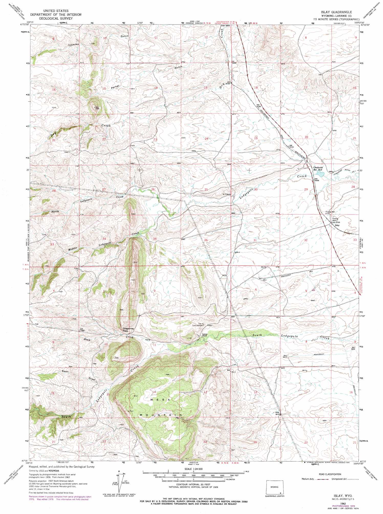
Islay Topo Map Wyoming
To zoom in, hover over the map of Islay
USGS Topo Quad 41105c2 - 1:24,000 scale
| Topo Map Name: | Islay |
| USGS Topo Quad ID: | 41105c2 |
| Print Size: | ca. 21 1/4" wide x 27" high |
| Southeast Coordinates: | 41.25° N latitude / 105.125° W longitude |
| Map Center Coordinates: | 41.3125° N latitude / 105.1875° W longitude |
| U.S. State: | WY |
| Filename: | o41105c2.jpg |
| Download Map JPG Image: | Islay topo map 1:24,000 scale |
| Map Type: | Topographic |
| Topo Series: | 7.5´ |
| Map Scale: | 1:24,000 |
| Source of Map Images: | United States Geological Survey (USGS) |
| Alternate Map Versions: |
Islay WY 1962, updated 1964 Download PDF Buy paper map Islay WY 1962, updated 1978 Download PDF Buy paper map Islay WY 2012 Download PDF Buy paper map Islay WY 2015 Download PDF Buy paper map |
1:24,000 Topo Quads surrounding Islay
Baldy Mountain |
Goat Mountain |
Farthing |
Hirsig Ranch |
Bristol Ridge |
King Mountain |
Ragged Top Mountain |
Horse Creek |
Dereemer Ranch |
Nimmo Ranch |
Pilot Hill |
Green Top Mountain |
Islay |
Federal |
Farthing Ranch |
Sherman Mountains West |
Sherman Mountains East |
Hecla |
Silver Crown |
Round Top Lake |
Dale Creek |
Buford |
Granite |
Emkay |
Borie |
> Back to 41105a1 at 1:100,000 scale
> Back to 41104a1 at 1:250,000 scale
> Back to U.S. Topo Maps home
Islay topo map: Gazetteer
Islay: Canals
Chadwick Ditch Number 1 elevation 2031m 6663′Chadwick Reservoir Number 3 elevation 2038m 6686′
Islay: Gaps
Cheyenne Pass elevation 2151m 7057′Islay: Mines
Bear Deposit elevation 2218m 7276′Beaver Claim elevation 2082m 6830′
Islay: Populated Places
Islay elevation 2045m 6709′Islay: Streams
Bean Creek elevation 2122m 6961′Middle Lodgepole Creek elevation 2073m 6801′
North Lodgepole Creek elevation 2073m 6801′
Islay: Summits
Mesa Mountain elevation 2318m 7604′Islay: Valleys
Bean Draw elevation 2171m 7122′Parker Gulch elevation 2031m 6663′
Islay digital topo map on disk
Buy this Islay topo map showing relief, roads, GPS coordinates and other geographical features, as a high-resolution digital map file on DVD:
Eastern Wyoming & Western South Dakota
Buy digital topo maps: Eastern Wyoming & Western South Dakota