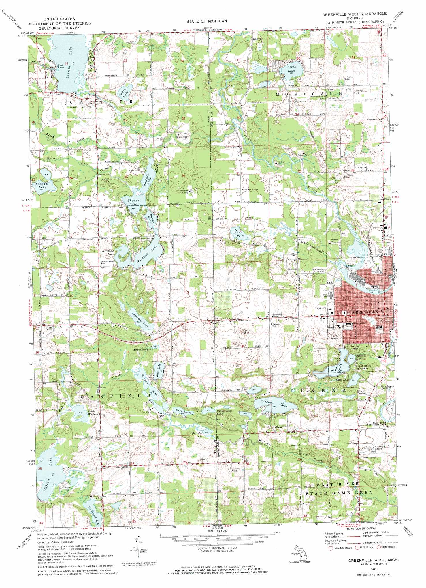
Greenville West Topo Map Michigan
To zoom in, hover over the map of Greenville West
USGS Topo Quad 43085b3 - 1:24,000 scale
| Topo Map Name: | Greenville West |
| USGS Topo Quad ID: | 43085b3 |
| Print Size: | ca. 21 1/4" wide x 27" high |
| Southeast Coordinates: | 43.125° N latitude / 85.25° W longitude |
| Map Center Coordinates: | 43.1875° N latitude / 85.3125° W longitude |
| U.S. State: | MI |
| Filename: | o43085b3.jpg |
| Download Map JPG Image: | Greenville West topo map 1:24,000 scale |
| Map Type: | Topographic |
| Topo Series: | 7.5´ |
| Map Scale: | 1:24,000 |
| Source of Map Images: | United States Geological Survey (USGS) |
| Alternate Map Versions: |
Greenville West MI 1972, updated 1974 Download PDF Buy paper map Greenville West MI 1972, updated 1974 Download PDF Buy paper map Greenville West MI 2011 Download PDF Buy paper map Greenville West MI 2014 Download PDF Buy paper map Greenville West MI 2017 Download PDF Buy paper map |
1:24,000 Topo Quads surrounding Greenville West
Tift Corner |
Howard City |
Lakeview |
Six Lakes |
Edmore |
Sand Lake |
Coral |
Trufant |
Langston |
Stanton |
Cedar Springs |
Evans |
Greenville West |
Greenville East |
Sheridan |
Rockford |
Cannonsburg |
Smyrna |
Belding |
Shiloh |
Grand Rapids East |
Cascade |
Lowell |
Saranac |
Ionia |
> Back to 43085a1 at 1:100,000 scale
> Back to 43084a1 at 1:250,000 scale
> Back to U.S. Topo Maps home
Greenville West topo map: Gazetteer
Greenville West: Airports
Greenville Municipal Airport elevation 258m 846′Greenville West: Lakes
Baldwin Lake elevation 244m 800′Banks Lake elevation 253m 830′
Bearslee Lake elevation 244m 800′
Bowen Lake elevation 257m 843′
Burgess Lake elevation 243m 797′
Como Lake elevation 244m 800′
County Line Lake elevation 244m 800′
Deer Lake elevation 244m 800′
Halfmile Lake elevation 253m 830′
Harlow Lake elevation 254m 833′
Horseshoe Lake elevation 253m 830′
Lincoln Lake elevation 255m 836′
Little Blue Lake elevation 245m 803′
Little Wabasis Lake elevation 249m 816′
Little Ziegenfuss Lake elevation 246m 807′
Manoka Lake elevation 244m 800′
Morgan Lake elevation 244m 800′
Perch Lake elevation 254m 833′
Saugage Lake elevation 259m 849′
Tek-E-Nink Lake elevation 248m 813′
Thomas Lake elevation 253m 830′
Woodbeck Lake elevation 253m 830′
Ziegenfuss Lake elevation 244m 800′
Greenville West: Parks
Baldwin Lake Beach elevation 250m 820′Greenville Historical Marker elevation 251m 823′
Hansen Park elevation 247m 810′
Heritage Park elevation 255m 836′
Saint Paul's Episcopal Church Historical Marker elevation 254m 833′
Tower Park elevation 249m 816′
Tower Riverside Park elevation 248m 813′
Veteran's Park elevation 276m 905′
White Pine Park elevation 259m 849′
Greenville West: Populated Places
Greenbriar Estates Mobile Home Park elevation 255m 836′Greenville elevation 255m 836′
Greenville West: Post Offices
Greenville Post Office elevation 256m 839′Lincoln Lake Post Office (historical) elevation 260m 853′
Spencers Mill Post Office (historical) elevation 258m 846′
Greenville West: Streams
Black Creek elevation 255m 836′Butternut Creek elevation 256m 839′
Clear Creek elevation 253m 830′
Coopers Creek elevation 250m 820′
Greenville West digital topo map on disk
Buy this Greenville West topo map showing relief, roads, GPS coordinates and other geographical features, as a high-resolution digital map file on DVD: