Cedar Springs Topo Map Michigan
To zoom in, hover over the map of Cedar Springs
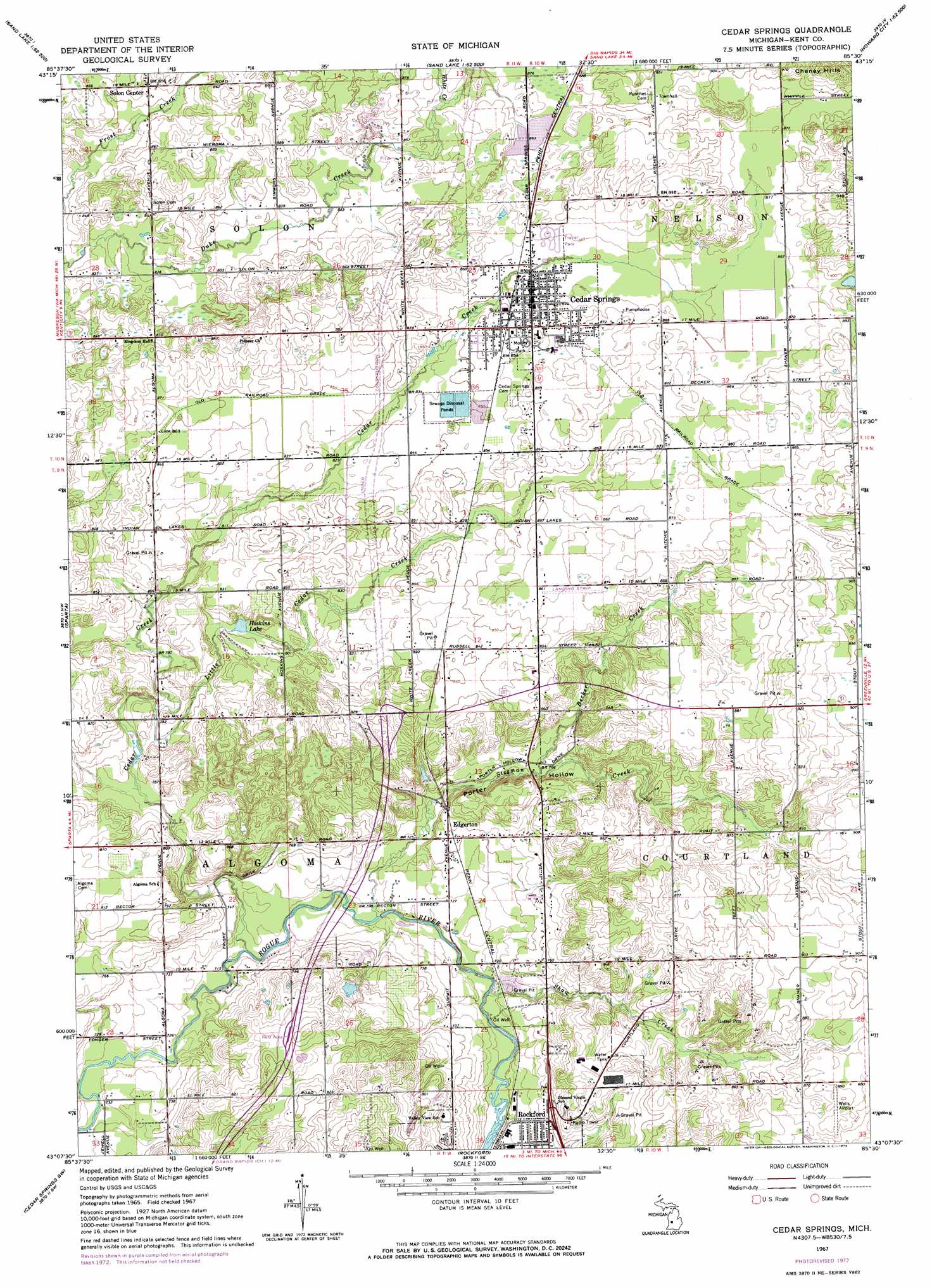
USGS Topo Quad 43085b5 - 1:24,000 scale
| Topo Map Name: | Cedar Springs |
| USGS Topo Quad ID: | 43085b5 |
| Print Size: | ca. 21 1/4" wide x 27" high |
| Southeast Coordinates: | 43.125° N latitude / 85.5° W longitude |
| Map Center Coordinates: | 43.1875° N latitude / 85.5625° W longitude |
| U.S. State: | MI |
| Filename: | o43085b5.jpg |
| Download Map JPG Image: | Cedar Springs topo map 1:24,000 scale |
| Map Type: | Topographic |
| Topo Series: | 7.5´ |
| Map Scale: | 1:24,000 |
| Source of Map Images: | United States Geological Survey (USGS) |
| Alternate Map Versions: |
Cedar Springs MI 1967, updated 1969 Download PDF Buy paper map Cedar Springs MI 1967, updated 1973 Download PDF Buy paper map Cedar Springs MI 2011 Download PDF Buy paper map Cedar Springs MI 2014 Download PDF Buy paper map Cedar Springs MI 2017 Download PDF Buy paper map |
1:24,000 Topo Quads surrounding Cedar Springs
Newaygo |
Croton |
Tift Corner |
Howard City |
Lakeview |
Grant |
Sand Lake Sw |
Sand Lake |
Coral |
Trufant |
Casnovia |
Sparta |
Cedar Springs |
Evans |
Greenville West |
Marne |
Cedar Springs Sw |
Rockford |
Cannonsburg |
Smyrna |
Grandville |
Grand Rapids West |
Grand Rapids East |
Cascade |
Lowell |
> Back to 43085a1 at 1:100,000 scale
> Back to 43084a1 at 1:250,000 scale
> Back to U.S. Topo Maps home
Cedar Springs topo map: Gazetteer
Cedar Springs: Airports
Wells Airport elevation 269m 882′Cedar Springs: Crossings
Interchange 101 elevation 268m 879′Interchange 104 elevation 265m 869′
Cedar Springs: Lakes
Hoskins Lake elevation 243m 797′Cedar Springs: Parks
Glen Park elevation 249m 816′Grand Rapids and Indiana Railroad Culvert Historical Marker elevation 226m 741′
Morley Park elevation 262m 859′
Cedar Springs: Populated Places
Cedar Springs elevation 261m 856′Cedar Springs Mobile Estates elevation 263m 862′
Cedarfield Mobile Home Park elevation 268m 879′
Chauteau Algoma Estates Mobile Home Park elevation 230m 754′
Edgerton elevation 230m 754′
Solon Center elevation 264m 866′
Cedar Springs: Post Offices
Algoma Post Office (historical) elevation 244m 800′Burch's Post Office (historical) elevation 263m 862′
Cedar Springs Post Office elevation 261m 856′
Edgerton Post Office (historical) elevation 230m 754′
Velzy Post Office (historical) elevation 262m 859′
Cedar Springs: Streams
Becker Creek elevation 231m 757′Cedar Creek elevation 216m 708′
Little Cedar Creek elevation 235m 770′
Shaw Creek elevation 213m 698′
Stegman Creek elevation 214m 702′
White Creek elevation 262m 859′
Cedar Springs: Summits
Cheney Hills elevation 290m 951′Cedar Springs: Valleys
Porter Hollow elevation 219m 718′Cedar Springs digital topo map on disk
Buy this Cedar Springs topo map showing relief, roads, GPS coordinates and other geographical features, as a high-resolution digital map file on DVD: