Searsmont Topo Map Maine
To zoom in, hover over the map of Searsmont
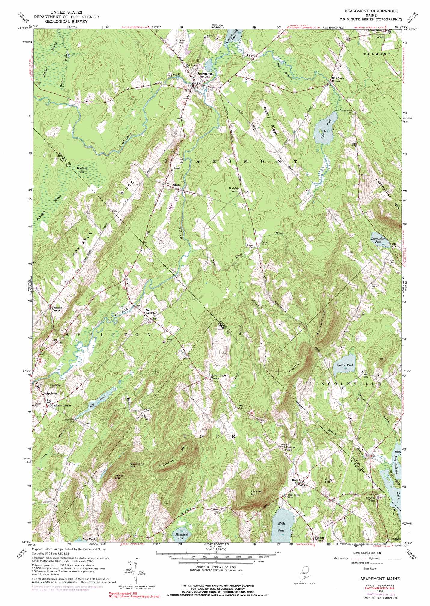
USGS Topo Quad 44069c2 - 1:24,000 scale
| Topo Map Name: | Searsmont |
| USGS Topo Quad ID: | 44069c2 |
| Print Size: | ca. 21 1/4" wide x 27" high |
| Southeast Coordinates: | 44.25° N latitude / 69.125° W longitude |
| Map Center Coordinates: | 44.3125° N latitude / 69.1875° W longitude |
| U.S. State: | ME |
| Filename: | o44069c2.jpg |
| Download Map JPG Image: | Searsmont topo map 1:24,000 scale |
| Map Type: | Topographic |
| Topo Series: | 7.5´ |
| Map Scale: | 1:24,000 |
| Source of Map Images: | United States Geological Survey (USGS) |
| Alternate Map Versions: |
Searsmont ME 1960, updated 1962 Download PDF Buy paper map Searsmont ME 1960, updated 1974 Download PDF Buy paper map Searsmont ME 1960, updated 1979 Download PDF Buy paper map Searsmont ME 1960, updated 1991 Download PDF Buy paper map Searsmont ME 2011 Download PDF Buy paper map Searsmont ME 2014 Download PDF Buy paper map |
1:24,000 Topo Quads surrounding Searsmont
Albion |
Unity |
Brooks West |
Brooks East |
Mount Waldo |
Palermo |
Liberty |
Morrill |
Belfast |
Searsport |
Razorville |
Washington |
Searsmont |
Lincolnville |
Islesboro |
Jefferson |
Union |
West Rockport |
Camden |
North Haven West |
Waldoboro West |
Waldoboro East |
Thomaston |
Rockland |
Leadbetter Island |
> Back to 44069a1 at 1:100,000 scale
> Back to 44068a1 at 1:250,000 scale
> Back to U.S. Topo Maps home
Searsmont topo map: Gazetteer
Searsmont: Airports
Ben Hur Heliport elevation 76m 249′Searsmont: Dams
Mill Pond Dam elevation 59m 193′Quantabacook Lake Dam elevation 56m 183′
Robbins Mill Dam elevation 52m 170′
Searsmont: Lakes
Lawry Pond elevation 66m 216′Levenseller Pond elevation 141m 462′
Mansfield Pond elevation 110m 360′
Moody Pond elevation 106m 347′
Searsmont: Populated Places
Athearns Corner elevation 137m 449′Bickfords Corner elevation 74m 242′
Ghent elevation 58m 190′
Grants Turn elevation 75m 246′
Greers Corner elevation 87m 285′
Gushees Corner elevation 80m 262′
Hope elevation 108m 354′
Knights Corner elevation 91m 298′
North Appleton elevation 57m 187′
North Hope Corner elevation 166m 544′
Payson Corner elevation 140m 459′
Pitmans Corner elevation 138m 452′
Searsmont elevation 70m 229′
Shermans Mill elevation 61m 200′
Slab City elevation 67m 219′
Searsmont: Reservoirs
Mill Pond elevation 59m 193′Quantabacook Lake elevation 56m 183′
Saint George River Reservoir elevation 52m 170′
Searsmont: Ridges
Appleton Ridge elevation 168m 551′Muzzy Ridge elevation 144m 472′
Searsmont: Streams
Black Brook elevation 74m 242′Jam Brook elevation 42m 137′
Luce Brook elevation 75m 246′
Marriners Brook elevation 44m 144′
Pease Brook elevation 59m 193′
Stearns Brook elevation 79m 259′
Wiley Brook elevation 43m 141′
Searsmont: Summits
Hatchet Mountain elevation 330m 1082′Jones Hill elevation 282m 925′
Levenseller Mountain elevation 317m 1040′
Moody Mountain elevation 284m 931′
Philbrick Mountain elevation 284m 931′
Simmons Hill elevation 288m 944′
Wiley Hill elevation 142m 465′
Searsmont: Swamps
Maple Meadow elevation 63m 206′Whitney Bog elevation 78m 255′
Searsmont digital topo map on disk
Buy this Searsmont topo map showing relief, roads, GPS coordinates and other geographical features, as a high-resolution digital map file on DVD:
Maine, New Hampshire, Rhode Island & Eastern Massachusetts
Buy digital topo maps: Maine, New Hampshire, Rhode Island & Eastern Massachusetts