Rattlesnake Butte Topo Map Montana
To zoom in, hover over the map of Rattlesnake Butte
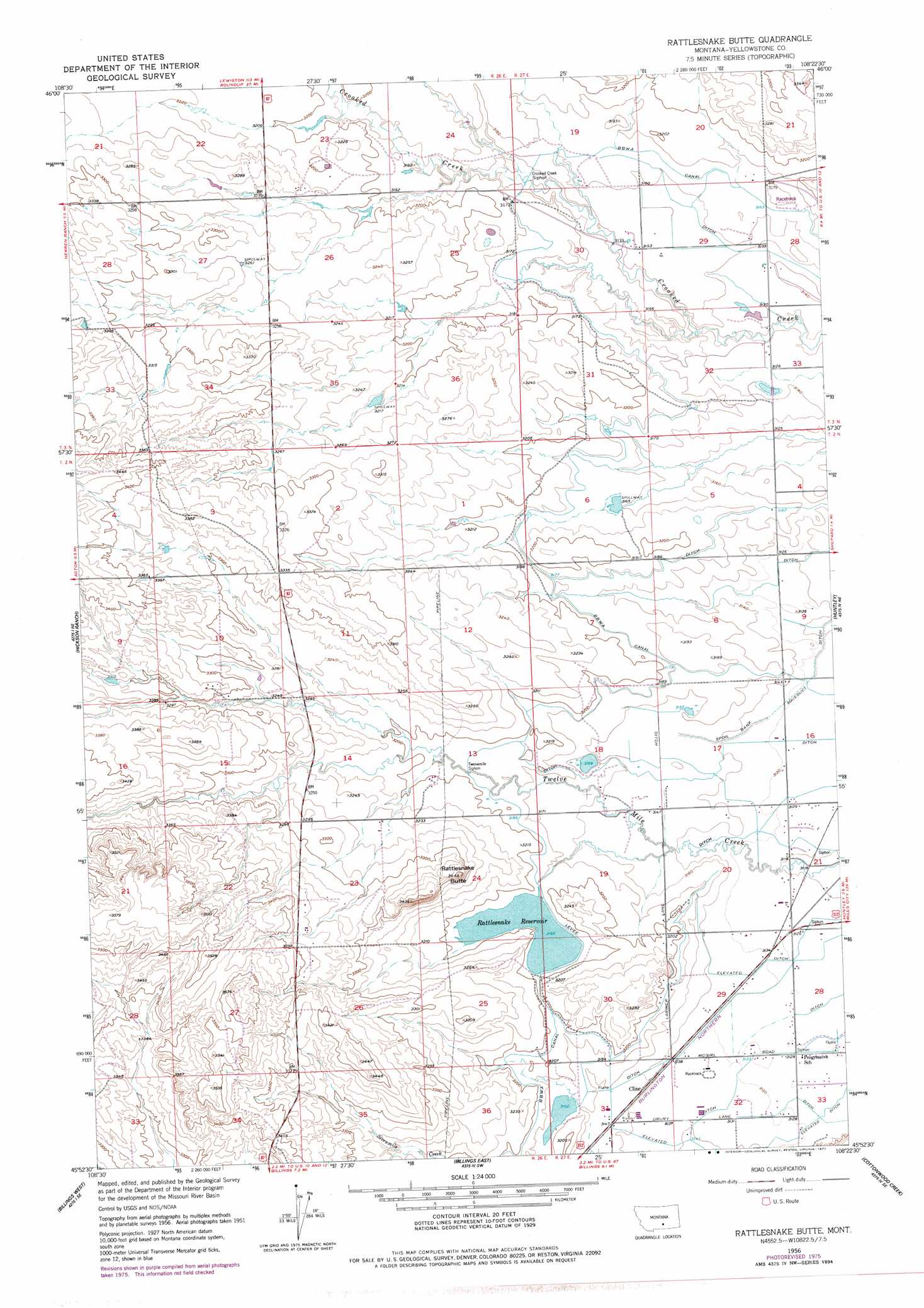
USGS Topo Quad 45108h4 - 1:24,000 scale
| Topo Map Name: | Rattlesnake Butte |
| USGS Topo Quad ID: | 45108h4 |
| Print Size: | ca. 21 1/4" wide x 27" high |
| Southeast Coordinates: | 45.875° N latitude / 108.375° W longitude |
| Map Center Coordinates: | 45.9375° N latitude / 108.4375° W longitude |
| U.S. State: | MT |
| Filename: | o45108h4.jpg |
| Download Map JPG Image: | Rattlesnake Butte topo map 1:24,000 scale |
| Map Type: | Topographic |
| Topo Series: | 7.5´ |
| Map Scale: | 1:24,000 |
| Source of Map Images: | United States Geological Survey (USGS) |
| Alternate Map Versions: |
Rattlesnake Butte MT 1956, updated 1957 Download PDF Buy paper map Rattlesnake Butte MT 1956, updated 1977 Download PDF Buy paper map Rattlesnake Butte MT 2011 Download PDF Buy paper map Rattlesnake Butte MT 2014 Download PDF Buy paper map |
1:24,000 Topo Quads surrounding Rattlesnake Butte
Hay Basin North |
Hay Basin Ne |
Park Coulee |
Dunn Mountain South |
P K Ranch |
Hay Basin South |
North Fork Crooked Creek West |
North Fork Crooked Creek East |
Cotton Creek |
P K Ranch Sw |
Acton |
Hickson Ranch |
Rattlesnake Butte |
Huntley |
Worden |
Rimrock |
Billings West |
Billings East |
Cottonwood Creek |
Indian Arrow |
Mossmain |
Yegen |
Soda Springs Nw |
Badbaby Coulee |
Woody Mountain Nw |
> Back to 45108e1 at 1:100,000 scale
> Back to 45108a1 at 1:250,000 scale
> Back to U.S. Topo Maps home
Rattlesnake Butte topo map: Gazetteer
Rattlesnake Butte: Canals
Crooked Creek Siphon elevation 961m 3152′Twelvemile Siphon elevation 970m 3182′
Rattlesnake Butte: Dams
Charter Number 1 Dam elevation 996m 3267′Rattlesnake Reservoir Dam elevation 973m 3192′
Retriever Number 1 Dam elevation 965m 3166′
Rattlesnake Butte: Populated Places
Cline elevation 958m 3143′Rattlesnake Butte: Reservoirs
Rattlesnake Reservoir elevation 975m 3198′Rattlesnake Butte: Summits
Rattlesnake Butte elevation 1020m 3346′Rattlesnake Butte: Wells
02N26E22DDCB01 Well elevation 1045m 3428′02N26E23C___01 Well elevation 1019m 3343′
02N26E26BCBC01 Well elevation 1029m 3375′
02N27E16CBBC01 Well elevation 954m 3129′
02N27E20ABBC01 Well elevation 958m 3143′
02N27E28BBBA01 Well elevation 953m 3126′
02N27E30BCCB01 Well elevation 985m 3231′
02N27E30DAAB01 Well elevation 976m 3202′
02N27E31ABBC01 Well elevation 967m 3172′
02N27E32AABB01 Well elevation 955m 3133′
03N27E32ADAA01 Well elevation 952m 3123′
Rattlesnake Butte digital topo map on disk
Buy this Rattlesnake Butte topo map showing relief, roads, GPS coordinates and other geographical features, as a high-resolution digital map file on DVD: