Salmon Topo Map Idaho
To zoom in, hover over the map of Salmon
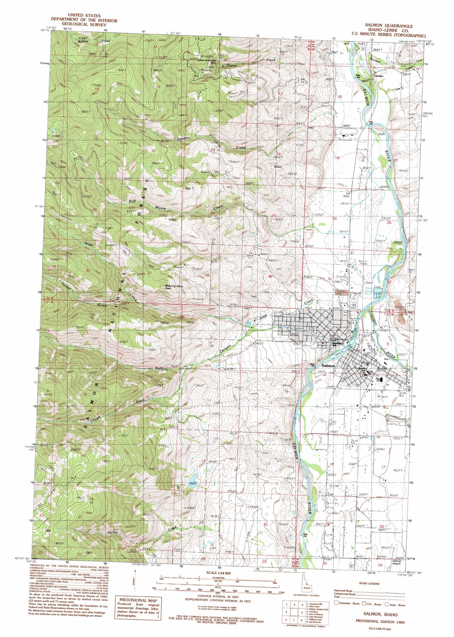
USGS Topo Quad 45113b8 - 1:24,000 scale
| Topo Map Name: | Salmon |
| USGS Topo Quad ID: | 45113b8 |
| Print Size: | ca. 21 1/4" wide x 27" high |
| Southeast Coordinates: | 45.125° N latitude / 113.875° W longitude |
| Map Center Coordinates: | 45.1875° N latitude / 113.9375° W longitude |
| U.S. State: | ID |
| Filename: | o45113b8.jpg |
| Download Map JPG Image: | Salmon topo map 1:24,000 scale |
| Map Type: | Topographic |
| Topo Series: | 7.5´ |
| Map Scale: | 1:24,000 |
| Source of Map Images: | United States Geological Survey (USGS) |
| Alternate Map Versions: |
Salmon NW ID 1974, updated 1977 Download PDF Buy paper map Salmon ID 1989, updated 1989 Download PDF Buy paper map Salmon ID 2011 Download PDF Buy paper map Salmon ID 2013 Download PDF Buy paper map |
| FStopo: | US Forest Service topo Salmon is available: Download FStopo PDF Download FStopo TIF |
1:24,000 Topo Quads surrounding Salmon
Ulysses |
Ulysses Mountain |
North Fork |
Shewag Lake |
Jumbo Mountain |
Pine Creek Ridge |
Napoleon Hill |
Bird Creek |
Badger Spring Gulch |
Homer Youngs Peak |
Jureano Mountain |
Leesburg |
Salmon |
East Of Salmon |
Bohannon Spring |
Cobalt |
Lake Mountain |
Williams Lake |
Sal Mountain |
Baker |
Taylor Mountain |
Degan Mountain |
Goldbug Ridge |
Poison Peak |
Tendoy |
> Back to 45113a1 at 1:100,000 scale
> Back to 45112a1 at 1:250,000 scale
> Back to U.S. Topo Maps home
Salmon topo map: Gazetteer
Salmon: Dams
Billy Creek Dam elevation 1500m 4921′Gorley Creek Dam elevation 1321m 4333′
Salmon: Mines
Queen of the Hills Mine elevation 1756m 5761′Salmon: Populated Places
Carmen elevation 1166m 3825′Salmon elevation 1202m 3943′
Salmon: Streams
Bob Moore Creek elevation 1207m 3959′Carmen Creek elevation 1166m 3825′
Chipps Creek elevation 1457m 4780′
Deriar Creek elevation 1199m 3933′
Fenster Creek elevation 1223m 4012′
Gorley Creek elevation 1351m 4432′
Jesse Creek elevation 1207m 3959′
Lemhi River elevation 1238m 4061′
Salmon: Summits
Morning Glory Peak elevation 1925m 6315′Salmon: Valleys
Lemhi Valley elevation 1196m 3923′Pollard Canyon elevation 1331m 4366′
Turner Gulch elevation 1717m 5633′
Salmon digital topo map on disk
Buy this Salmon topo map showing relief, roads, GPS coordinates and other geographical features, as a high-resolution digital map file on DVD: