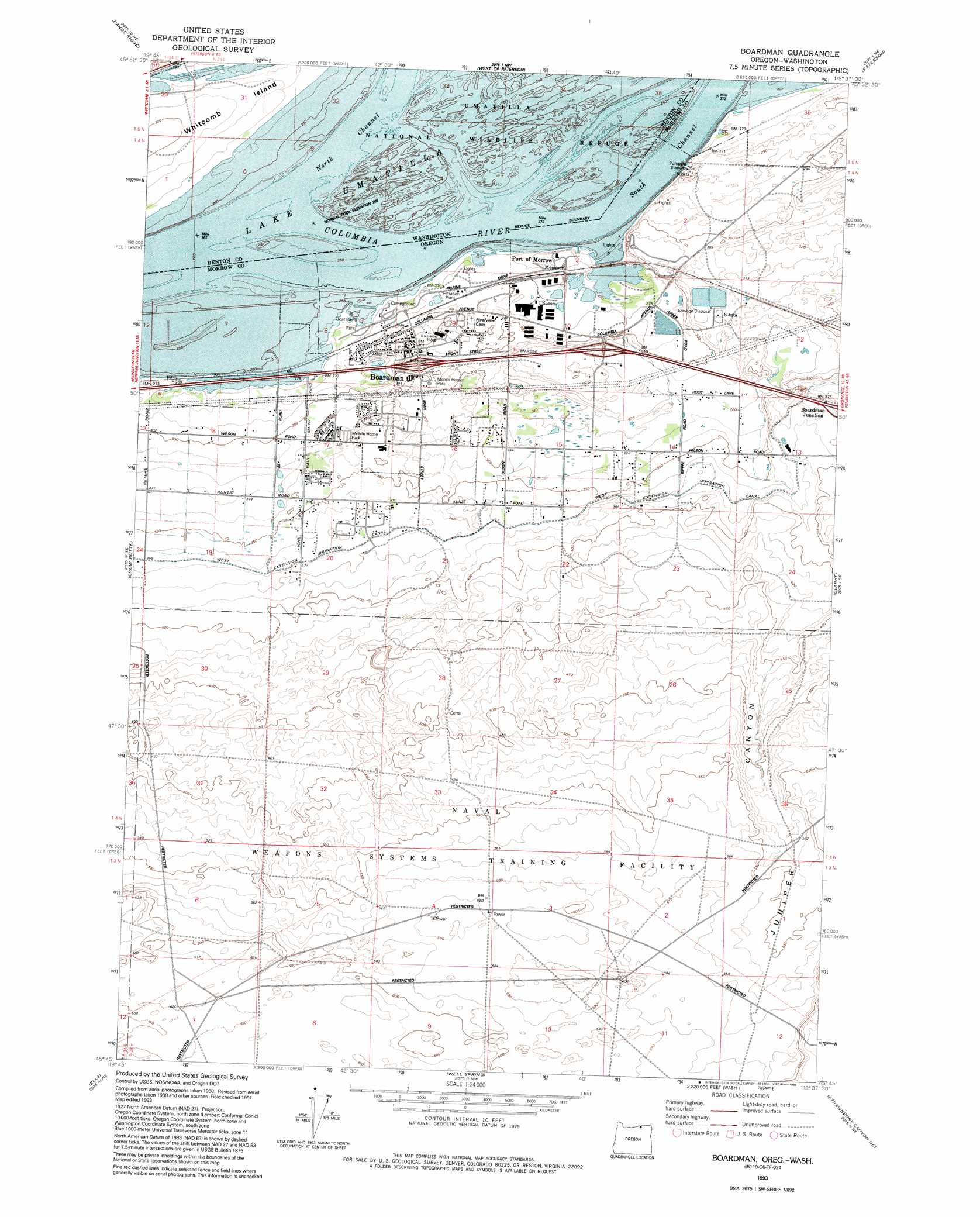
Boardman Topo Map Oregon
To zoom in, hover over the map of Boardman
USGS Topo Quad 45119g6 - 1:24,000 scale
| Topo Map Name: | Boardman |
| USGS Topo Quad ID: | 45119g6 |
| Print Size: | ca. 21 1/4" wide x 27" high |
| Southeast Coordinates: | 45.75° N latitude / 119.625° W longitude |
| Map Center Coordinates: | 45.8125° N latitude / 119.6875° W longitude |
| U.S. States: | OR, WA |
| Filename: | o45119g6.jpg |
| Download Map JPG Image: | Boardman topo map 1:24,000 scale |
| Map Type: | Topographic |
| Topo Series: | 7.5´ |
| Map Scale: | 1:24,000 |
| Source of Map Images: | United States Geological Survey (USGS) |
| Alternate Map Versions: |
Boardman OR 1962, updated 1963 Download PDF Buy paper map Boardman OR 1962, updated 1972 Download PDF Buy paper map Boardman OR 1962, updated 1979 Download PDF Buy paper map Boardman OR 1993, updated 1993 Download PDF Buy paper map Boardman OR 2011 Download PDF Buy paper map Boardman OR 2014 Download PDF Buy paper map |
1:24,000 Topo Quads surrounding Boardman
Prosser Sw |
Prosser Se |
Lenzie Ranch |
Whitstran Se |
Prior Ranch |
Phinny Hill |
Canoe Ridge |
Blalock Island |
Paterson |
Irrigon |
Alderdale |
Crow Butte |
Boardman |
Clarke |
Ordnance |
Dalreed Butte |
Ella |
Well Spring |
Strawberry Canyon Ne |
Ward Butte |
Cecil |
Ione North |
Strawberry Canyon Sw |
Strawberry Canyon Se |
Butter Creek Junction |
> Back to 45119e1 at 1:100,000 scale
> Back to 45118a1 at 1:250,000 scale
> Back to U.S. Topo Maps home
Boardman topo map: Gazetteer
Boardman: Channels
Messinger Lower Range elevation 82m 269′Messinger Middle Range elevation 82m 269′
Messinger Upper Range elevation 82m 269′
Boardman: Harbors
Port of Morrow elevation 83m 272′Boardman: Islands
Coyote Island elevation 82m 269′Coyote Island (historical) elevation 82m 269′
Coyote Islands (historical) elevation 82m 269′
Whitcomb Island elevation 87m 285′
Boardman: Parks
Boardman Marina Park elevation 83m 272′Boardman: Populated Places
Boardman elevation 95m 311′Boardman: Post Offices
Boardman Post Office elevation 95m 311′Coyote Post Office (historical) elevation 82m 269′
Boardman: Springs
Coyote Spring elevation 96m 314′Boardman: Swamps
Messner Marsh elevation 99m 324′Boardman: Valleys
Juniper Canyon elevation 130m 426′Boardman digital topo map on disk
Buy this Boardman topo map showing relief, roads, GPS coordinates and other geographical features, as a high-resolution digital map file on DVD: