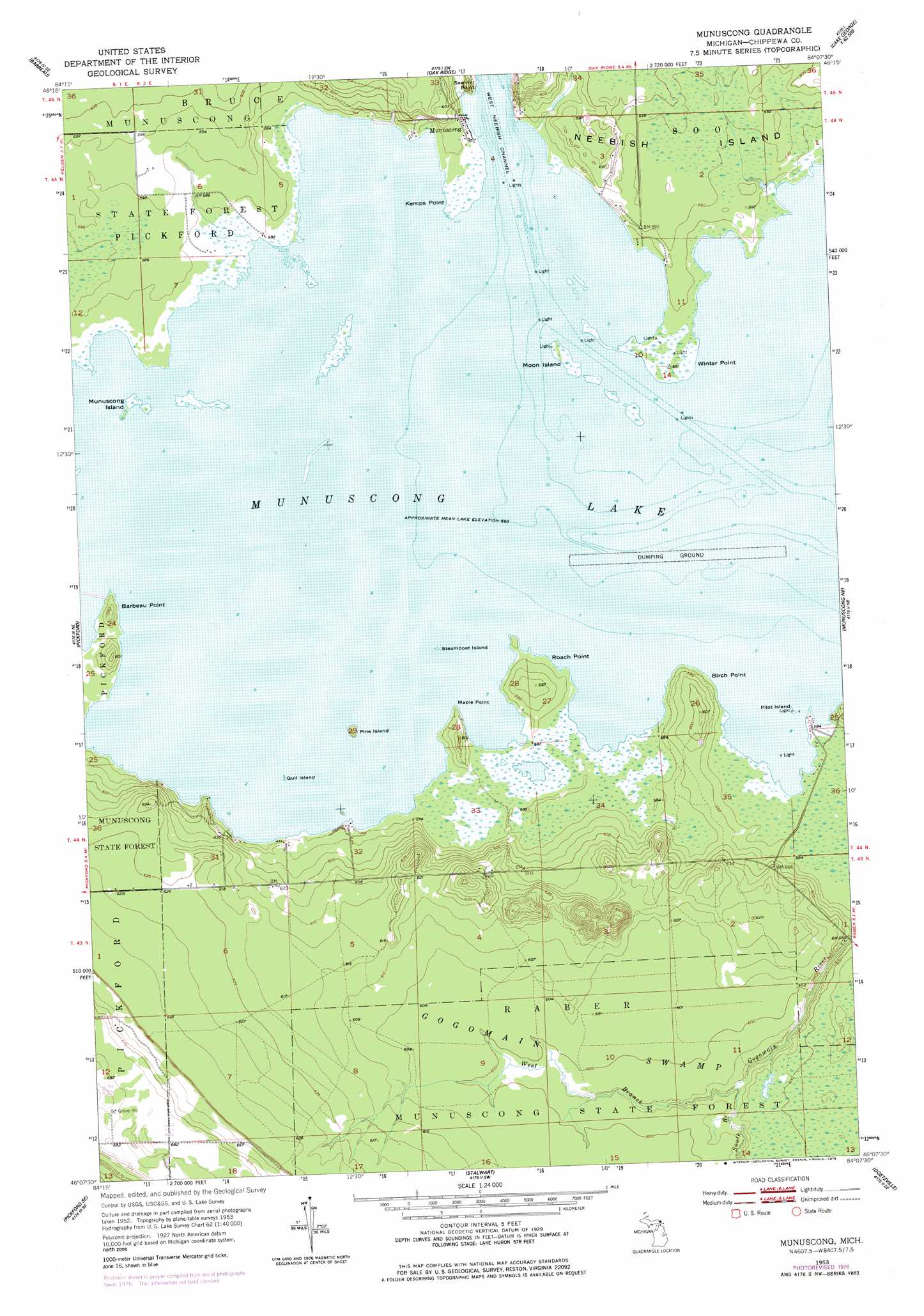
Munuscong Topo Map Michigan
To zoom in, hover over the map of Munuscong
USGS Topo Quad 46084b2 - 1:24,000 scale
| Topo Map Name: | Munuscong |
| USGS Topo Quad ID: | 46084b2 |
| Print Size: | ca. 21 1/4" wide x 27" high |
| Southeast Coordinates: | 46.125° N latitude / 84.125° W longitude |
| Map Center Coordinates: | 46.1875° N latitude / 84.1875° W longitude |
| U.S. State: | MI |
| Filename: | o46084b2.jpg |
| Download Map JPG Image: | Munuscong topo map 1:24,000 scale |
| Map Type: | Topographic |
| Topo Series: | 7.5´ |
| Map Scale: | 1:24,000 |
| Source of Map Images: | United States Geological Survey (USGS) |
| Alternate Map Versions: |
Munuscong MI 1953, updated 1955 Download PDF Buy paper map Munuscong MI 1953, updated 1978 Download PDF Buy paper map Munuscong MI 2011 Download PDF Buy paper map Munuscong MI 2014 Download PDF Buy paper map Munuscong MI 2017 Download PDF Buy paper map |
1:24,000 Topo Quads surrounding Munuscong
Shallows |
Sault Sainte Marie South |
Baie De Wasai |
||
Dafter |
Barbeau |
Oak Ridge |
||
Pickford Nw |
Pickford |
Munuscong |
Munuscong Ne |
|
Hessel |
Pickford Se |
Stalwart |
Goetzville |
Lime Island |
Goose Island |
Cedarville |
Prentiss Bay |
Albany Island |
De Tour Village |
> Back to 46084a1 at 1:100,000 scale
> Back to 46084a1 at 1:250,000 scale
> Back to U.S. Topo Maps home
Munuscong topo map: Gazetteer
Munuscong: Capes
Barbeau Point elevation 182m 597′Birch Point elevation 182m 597′
Kemps Point elevation 178m 583′
Maple Point elevation 182m 597′
Roach Point elevation 182m 597′
Sawmill Point elevation 180m 590′
Winter Point elevation 178m 583′
Munuscong: Forests
Munuscong State Forest elevation 191m 626′Munuscong: Islands
Gull Island elevation 178m 583′Moon Island elevation 178m 583′
Munuscong Island elevation 178m 583′
Pilot Island elevation 178m 583′
Pine Island elevation 178m 583′
Steamboat Island elevation 177m 580′
Munuscong: Lakes
Munuscong Lake elevation 177m 580′Munuscong: Populated Places
Munuscong elevation 179m 587′Munuscong: Post Offices
Munuscong Post Office (historical) elevation 179m 587′Nunuscong Post Office (historical) elevation 179m 587′
Munuscong: Streams
South Branch Gogomain River elevation 180m 590′West Branch Gogomain River elevation 180m 590′
Munuscong digital topo map on disk
Buy this Munuscong topo map showing relief, roads, GPS coordinates and other geographical features, as a high-resolution digital map file on DVD: