Lake Park Sw Topo Map Minnesota
To zoom in, hover over the map of Lake Park Sw
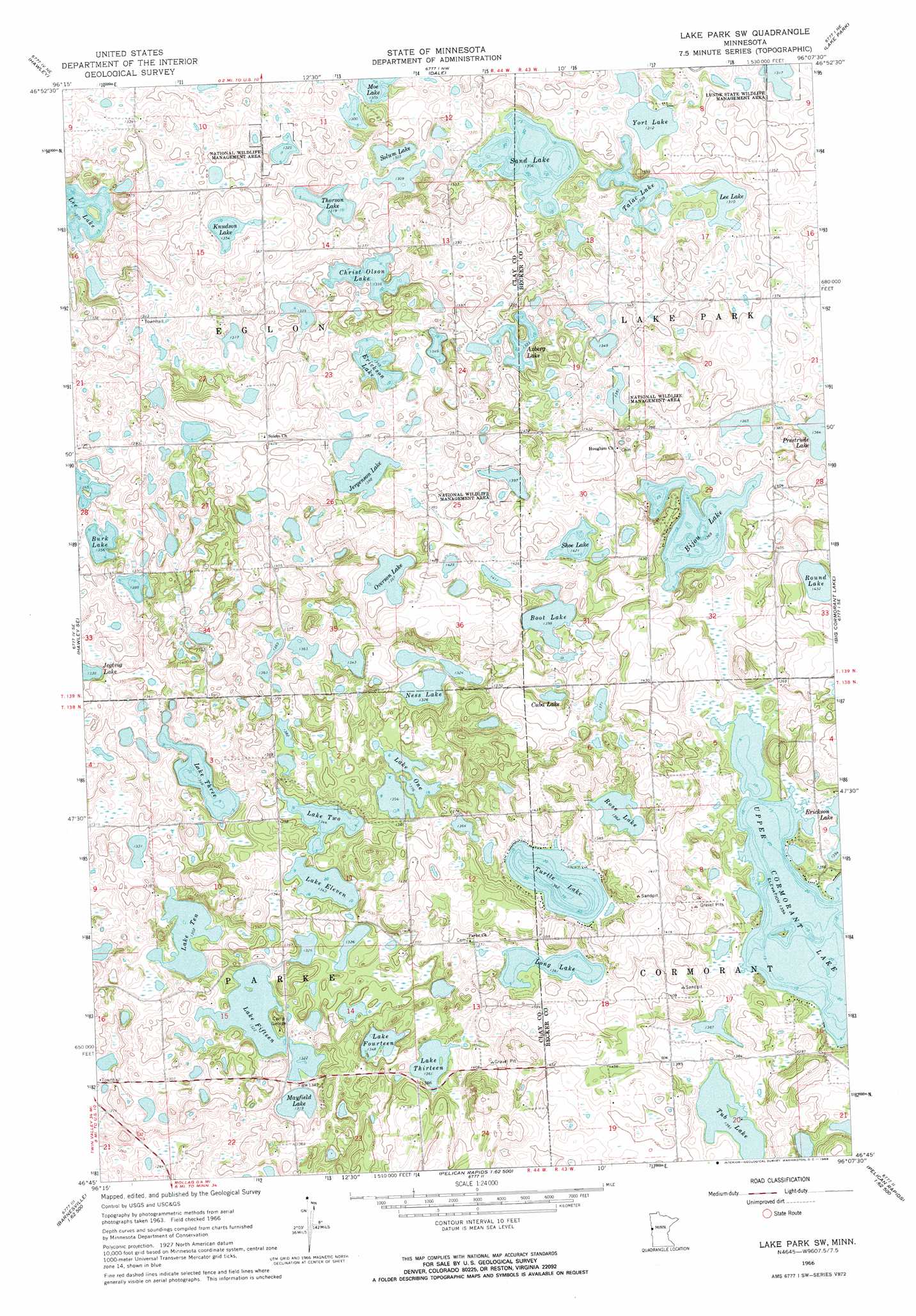
USGS Topo Quad 46096g2 - 1:24,000 scale
| Topo Map Name: | Lake Park Sw |
| USGS Topo Quad ID: | 46096g2 |
| Print Size: | ca. 21 1/4" wide x 27" high |
| Southeast Coordinates: | 46.75° N latitude / 96.125° W longitude |
| Map Center Coordinates: | 46.8125° N latitude / 96.1875° W longitude |
| U.S. State: | MN |
| Filename: | o46096g2.jpg |
| Download Map JPG Image: | Lake Park Sw topo map 1:24,000 scale |
| Map Type: | Topographic |
| Topo Series: | 7.5´ |
| Map Scale: | 1:24,000 |
| Source of Map Images: | United States Geological Survey (USGS) |
| Alternate Map Versions: |
Lake Park SW MN 1966, updated 1968 Download PDF Buy paper map Lake Park SW MN 2010 Download PDF Buy paper map Lake Park SW MN 2013 Download PDF Buy paper map Lake Park SW MN 2016 Download PDF Buy paper map |
1:24,000 Topo Quads surrounding Lake Park Sw
Ulen Sw |
Ulen |
Tilde Lake |
Flom Se |
Ogema |
Hawley Nw |
Hawley |
Dale |
Lake Park |
Mount Rainier East |
Downer |
Hawley Se |
Lake Park Sw |
Big Cormorant Lake |
Audubon |
Barnesville |
Big Slough |
Rollag |
Cormorant |
Lake Franklin |
Barnesville Sw |
Lawndale |
Lake Olaf |
Pelican Rapids |
Lake Lida |
> Back to 46096e1 at 1:100,000 scale
> Back to 46096a1 at 1:250,000 scale
> Back to U.S. Topo Maps home
Lake Park Sw topo map: Gazetteer
Lake Park Sw: Airports
Johnston Airport elevation 415m 1361′Lake Park Sw: Lakes
Axberg Lake elevation 408m 1338′Bijou Lake elevation 418m 1371′
Boot Lake elevation 426m 1397′
Burk Lake elevation 414m 1358′
Christ Olson Lake elevation 408m 1338′
Cuba Lake elevation 420m 1377′
Erickson Lake elevation 412m 1351′
Jergenson Lake elevation 412m 1351′
Knudson Lake elevation 413m 1354′
Lake Eleven elevation 409m 1341′
Lake Fifteen elevation 403m 1322′
Lake Fourteen elevation 409m 1341′
Lake One elevation 414m 1358′
Lake Ten elevation 397m 1302′
Lake Thirteen elevation 415m 1361′
Lake Three elevation 409m 1341′
Lake Two elevation 409m 1341′
Lee Lake elevation 400m 1312′
Long Lake elevation 415m 1361′
Mansfield Lake elevation 401m 1315′
Ness Lake elevation 403m 1322′
Overson Lake elevation 422m 1384′
Prestrude Lake elevation 416m 1364′
Rose Lake elevation 415m 1361′
Round Lake elevation 437m 1433′
Sand Lake elevation 398m 1305′
Shoe Lake elevation 433m 1420′
Solum Lake elevation 397m 1302′
Talac Lake elevation 399m 1309′
Thorson Lake elevation 402m 1318′
Tub Lake elevation 415m 1361′
Turtle Lake elevation 415m 1361′
Upper Cormorant Lake elevation 413m 1354′
York Lake elevation 400m 1312′
Lake Park Sw: Parks
Lunde State Wildlife Management Area elevation 403m 1322′Lake Park Sw digital topo map on disk
Buy this Lake Park Sw topo map showing relief, roads, GPS coordinates and other geographical features, as a high-resolution digital map file on DVD:
Eastern North Dakota & Eastern South Dakota
Buy digital topo maps: Eastern North Dakota & Eastern South Dakota