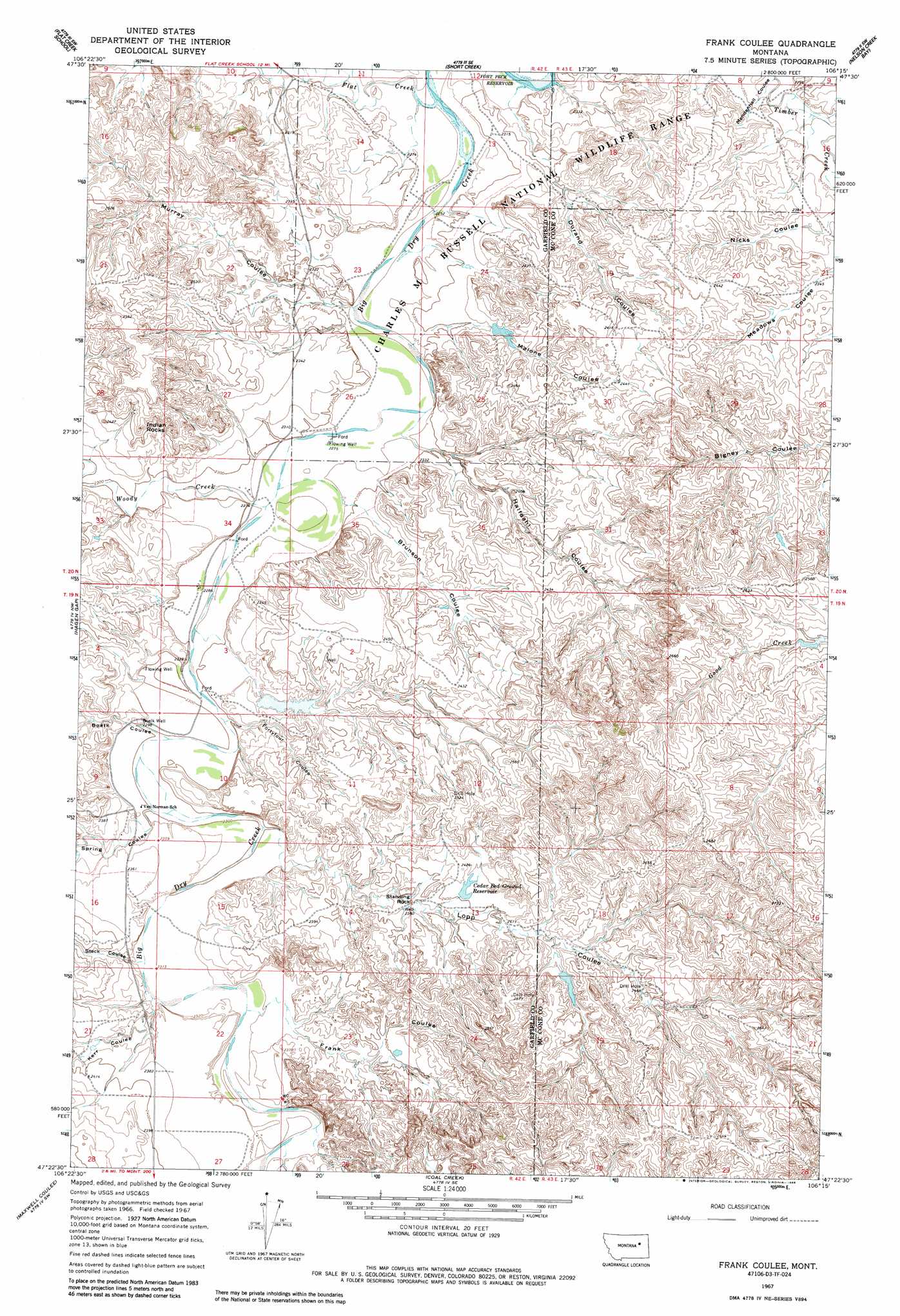
Frank Coulee Topo Map Montana
To zoom in, hover over the map of Frank Coulee
USGS Topo Quad 47106d3 - 1:24,000 scale
| Topo Map Name: | Frank Coulee |
| USGS Topo Quad ID: | 47106d3 |
| Print Size: | ca. 21 1/4" wide x 27" high |
| Southeast Coordinates: | 47.375° N latitude / 106.25° W longitude |
| Map Center Coordinates: | 47.4375° N latitude / 106.3125° W longitude |
| U.S. State: | MT |
| Filename: | o47106d3.jpg |
| Download Map JPG Image: | Frank Coulee topo map 1:24,000 scale |
| Map Type: | Topographic |
| Topo Series: | 7.5´ |
| Map Scale: | 1:24,000 |
| Source of Map Images: | United States Geological Survey (USGS) |
| Alternate Map Versions: |
Frank Coulee MT 1967, updated 1970 Download PDF Buy paper map Frank Coulee MT 1967, updated 1984 Download PDF Buy paper map Frank Coulee MT 2011 Download PDF Buy paper map Frank Coulee MT 2014 Download PDF Buy paper map |
1:24,000 Topo Quads surrounding Frank Coulee
Gilbert Creek |
Ash Creek West |
Ash Creek East |
Bug Creek |
Crow Springs |
Gilbert Creek Se |
Flat Creek School |
Short Creek |
Nelson Creek Bay |
Rodgers Hall |
Bateman Coulee Ne |
Hagen Gap |
Frank Coulee |
Fortyfour Coulee |
Johnson Coulee West |
Ada Creek |
Maxwell Coulee |
Coal Creek |
Flowing Well |
Cemetery Coulee |
Cohagen Ne |
Hafla School |
Whiteside Ranch |
Hedstrom Lake Nw |
Hedstrom Lake |
> Back to 47106a1 at 1:100,000 scale
> Back to 47106a1 at 1:250,000 scale
> Back to U.S. Topo Maps home
Frank Coulee topo map: Gazetteer
Frank Coulee: Dams
Billings Number 3 Dam elevation 714m 2342′McKerlic Number 1 Dam elevation 712m 2335′
Frank Coulee: Reservoirs
Cedar Bed Ground Reservoir elevation 732m 2401′Frank Coulee: Streams
Flat Creek elevation 689m 2260′Woody Creek elevation 695m 2280′
Frank Coulee: Summits
Indian Rocks elevation 752m 2467′Standing Rock elevation 735m 2411′
Frank Coulee: Valleys
Boelk Coulee elevation 701m 2299′Brunson Coulee elevation 696m 2283′
Durand Coulee elevation 689m 2260′
Fortyfour Coulee elevation 702m 2303′
Frank Coulee elevation 713m 2339′
Halfdahl Coulee elevation 696m 2283′
Kerr Coulee elevation 707m 2319′
Lopp Coulee elevation 704m 2309′
Malone Coulee elevation 691m 2267′
Meadows Coulee elevation 713m 2339′
Murray Coulee elevation 689m 2260′
Nicks Coulee elevation 707m 2319′
Spring Coulee elevation 702m 2303′
Steck Coulee elevation 708m 2322′
Frank Coulee: Wells
19N42E03B___01 Well elevation 709m 2326′19N42E03BB__01 Well elevation 698m 2290′
19N42E03C___01 Well elevation 702m 2303′
19N42E09A___01 Well elevation 704m 2309′
19N42E09AAAD01 Well elevation 703m 2306′
19N42E10C___01 Well elevation 700m 2296′
19N42E14AD__01 Well elevation 736m 2414′
19N42E21A___01 Well elevation 722m 2368′
19N42E26B___01 Well elevation 714m 2342′
19N42E27ADBB01 Well elevation 713m 2339′
20N42E14D___01 Well elevation 702m 2303′
20N42E22CA__01 Well elevation 739m 2424′
20N42E23AB__01 Well elevation 697m 2286′
20N42E34A___01 Well elevation 697m 2286′
20N42E34AB__01 Well elevation 697m 2286′
20N42E34AC__01 Well elevation 695m 2280′
20N42E34CA__01 Well elevation 712m 2335′
Boelk Well elevation 701m 2299′
Frank Coulee digital topo map on disk
Buy this Frank Coulee topo map showing relief, roads, GPS coordinates and other geographical features, as a high-resolution digital map file on DVD:
Eastern Montana & Western North Dakota
Buy digital topo maps: Eastern Montana & Western North Dakota