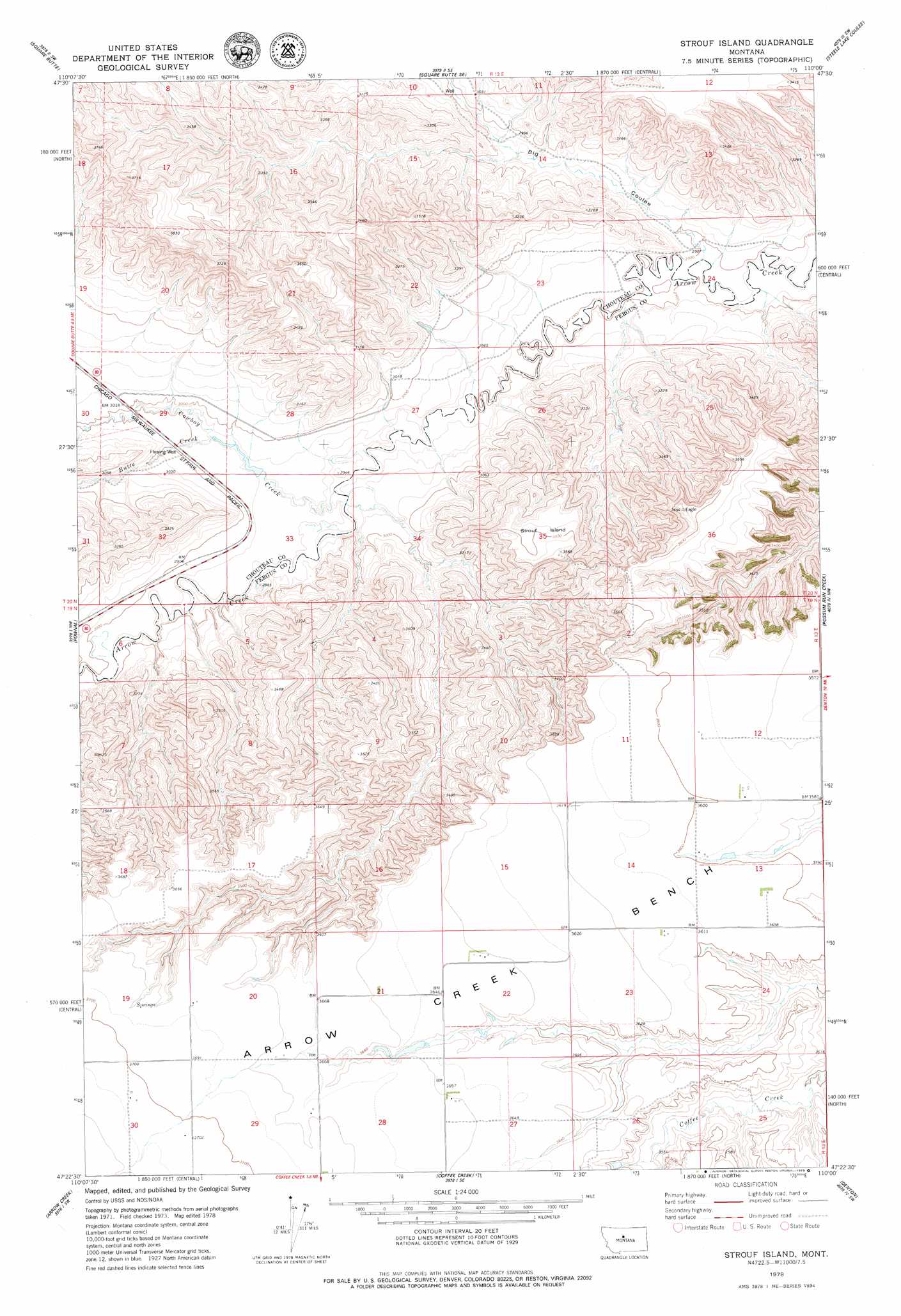
Strouf Island Topo Map Montana
To zoom in, hover over the map of Strouf Island
USGS Topo Quad 47110d1 - 1:24,000 scale
| Topo Map Name: | Strouf Island |
| USGS Topo Quad ID: | 47110d1 |
| Print Size: | ca. 21 1/4" wide x 27" high |
| Southeast Coordinates: | 47.375° N latitude / 110° W longitude |
| Map Center Coordinates: | 47.4375° N latitude / 110.0625° W longitude |
| U.S. State: | MT |
| Filename: | o47110d1.jpg |
| Download Map JPG Image: | Strouf Island topo map 1:24,000 scale |
| Map Type: | Topographic |
| Topo Series: | 7.5´ |
| Map Scale: | 1:24,000 |
| Source of Map Images: | United States Geological Survey (USGS) |
| Alternate Map Versions: |
Strouf Island MT 1978, updated 1979 Download PDF Buy paper map Strouf Island MT 2011 Download PDF Buy paper map Strouf Island MT 2014 Download PDF Buy paper map |
1:24,000 Topo Quads surrounding Strouf Island
Geraldine Ne |
Dammel Reservoir |
Square Butte Ne |
Last Chance Bench |
Starve Out Flat |
Geraldine |
Square Butte |
Square Butte Se |
Steele Lake Coulee |
Spring Coulee |
Jiggs Flat |
Pownal |
Strouf Island |
Possum Run Creek |
Soda Spring Coulee |
Leiberg Coulee |
Arrow Creek |
Coffee Creek |
Denton |
Hoosac |
Merino |
Stanford |
Stanford Ne |
Big Spring |
Harwood Bench |
> Back to 47110a1 at 1:100,000 scale
> Back to 47110a1 at 1:250,000 scale
> Back to U.S. Topo Maps home
Strouf Island topo map: Gazetteer
Strouf Island: Benches
Arrow Creek Bench elevation 1108m 3635′Strouf Island elevation 1069m 3507′
Strouf Island: Dams
Cafe Mocha Dam elevation 1110m 3641′Coffee Mate Dam elevation 1110m 3641′
Dieanira Dam elevation 909m 2982′
Strouf Island: Streams
Butte Creek elevation 909m 2982′Cowboy Creek elevation 904m 2965′
Strouf Island: Valleys
Big Coulee elevation 882m 2893′Strouf Island: Wells
19N13E01DA__01 Well elevation 1089m 3572′19N13E12CDC_01 Well elevation 1100m 3608′
19N13E22BAC_01 Well elevation 1111m 3645′
19N13E22BBDA01 Well elevation 1110m 3641′
19N13E29AAAA01 Well elevation 1119m 3671′
19N13E29BABB01 Well elevation 1125m 3690′
19N13E29BCAA01 Well elevation 1125m 3690′
19N13E29BCBD01 Well elevation 1128m 3700′
19N13E29BCCC01 Well elevation 1129m 3704′
19N14E07BCB_01 Well elevation 1088m 3569′
20N13E20CACA01 Well elevation 979m 3211′
20N13E25BAAA01 Well elevation 906m 2972′
20N13E26AAD_01 Well elevation 942m 3090′
20N13E27ABC_01 Well elevation 891m 2923′
Strouf Island digital topo map on disk
Buy this Strouf Island topo map showing relief, roads, GPS coordinates and other geographical features, as a high-resolution digital map file on DVD: