Lighthouse Hill Topo Map Montana
To zoom in, hover over the map of Lighthouse Hill
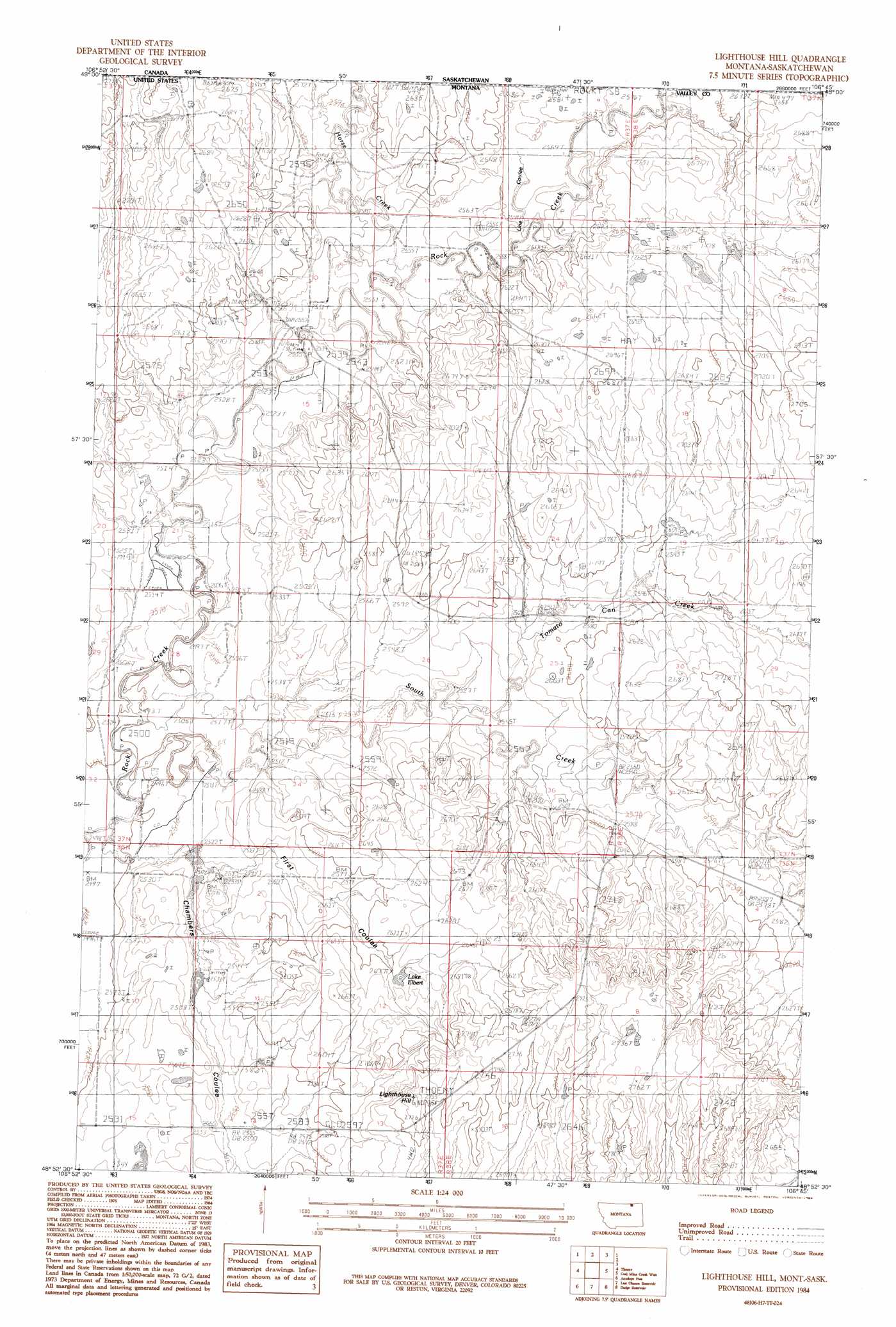
USGS Topo Quad 48106h7 - 1:24,000 scale
| Topo Map Name: | Lighthouse Hill |
| USGS Topo Quad ID: | 48106h7 |
| Print Size: | ca. 21 1/4" wide x 27" high |
| Southeast Coordinates: | 48.875° N latitude / 106.75° W longitude |
| Map Center Coordinates: | 48.9375° N latitude / 106.8125° W longitude |
| U.S. State: | MT |
| Filename: | o48106h7.jpg |
| Download Map JPG Image: | Lighthouse Hill topo map 1:24,000 scale |
| Map Type: | Topographic |
| Topo Series: | 7.5´ |
| Map Scale: | 1:24,000 |
| Source of Map Images: | United States Geological Survey (USGS) |
| Alternate Map Versions: |
Lighthouse Hill MT 1984, updated 1984 Download PDF Buy paper map Lighthouse Hill MT 2011 Download PDF Buy paper map Lighthouse Hill MT 2014 Download PDF Buy paper map |
1:24,000 Topo Quads surrounding Lighthouse Hill
Black Calf Reservoir |
Thoeny |
Lighthouse Hill |
Coal Mine Creek West |
Coal Mine Creek East |
Snake Creek School |
Antelope Pass |
Last Chance Res. |
Dodge Reservoir |
O'Juel Lake |
Papoose Hills |
Burnett Creek |
Gay Dam |
Kerr Cow Camp |
Wards Dam |
> Back to 48106e1 at 1:100,000 scale
> Back to 48106a1 at 1:250,000 scale
> Back to U.S. Topo Maps home
Lighthouse Hill topo map: Gazetteer
Lighthouse Hill: Dams
Brown Cow Dam elevation 760m 2493′Canoe Dam elevation 799m 2621′
Chambers Dam elevation 766m 2513′
Frank Stuber Number 1 Dam elevation 773m 2536′
VR-57 Dam elevation 810m 2657′
Lighthouse Hill: Lakes
Lake Elbert elevation 797m 2614′Lighthouse Hill: Post Offices
Barnard Post Office (historical) elevation 814m 2670′Lighthouse Hill: Streams
Horse Creek elevation 774m 2539′South Creek elevation 760m 2493′
Lighthouse Hill: Summits
Lighthouse Hill elevation 837m 2746′Lighthouse Hill: Valleys
Chambers Coulee elevation 768m 2519′First Coulee elevation 768m 2519′
Line Coulee elevation 777m 2549′
Lighthouse Hill digital topo map on disk
Buy this Lighthouse Hill topo map showing relief, roads, GPS coordinates and other geographical features, as a high-resolution digital map file on DVD:
Eastern Montana & Western North Dakota
Buy digital topo maps: Eastern Montana & Western North Dakota