Mogotes Hill Topo Map Texas
To zoom in, hover over the map of Mogotes Hill
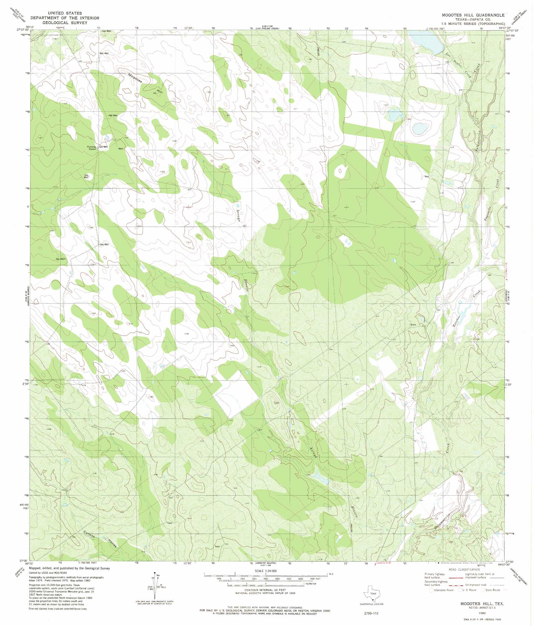
USGS Topo Quad 27099a2 - 1:24,000 scale
| Topo Map Name: | Mogotes Hill |
| USGS Topo Quad ID: | 27099a2 |
| Print Size: | ca. 21 1/4" wide x 27" high |
| Southeast Coordinates: | 27° N latitude / 99.125° W longitude |
| Map Center Coordinates: | 27.0625° N latitude / 99.1875° W longitude |
| U.S. State: | TX |
| Filename: | o27099a2.jpg |
| Download Map JPG Image: | Mogotes Hill topo map 1:24,000 scale |
| Map Type: | Topographic |
| Topo Series: | 7.5´ |
| Map Scale: | 1:24,000 |
| Source of Map Images: | United States Geological Survey (USGS) |
| Alternate Map Versions: |
Mogotes Hill TX 1980, updated 1980 Download PDF Buy paper map Mogotes Hill TX 2010 Download PDF Buy paper map Mogotes Hill TX 2013 Download PDF Buy paper map Mogotes Hill TX 2016 Download PDF Buy paper map |
1:24,000 Topo Quads surrounding Mogotes Hill
O'Keefe Lake |
Blancas Creek South |
Agua Azul Creek West |
Agua Azul Creek East |
Albercas Ranch |
Arroyo Salado West |
Arroyo Salado East |
Las Ovejas Creek |
Chargos Creek |
Thompsonville |
San Ygnacio |
Arroyo Burro |
Mogotes Hill |
Escobas |
Randado |
Zapata Nw |
Zapata |
Arroyo Veleno |
Arroyo Huisache |
Guerra |
Zapata Se |
Arroyo Clareno |
Arroyo Miguel |
Cuevitas Sw |
> Back to 27099a1 at 1:100,000 scale
> Back to 27098a1 at 1:250,000 scale
> Back to U.S. Topo Maps home
Mogotes Hill topo map: Gazetteer
Mogotes Hill: Dams
Roy Jennings Lake Dam elevation 126m 413′Mogotes Hill: Reservoirs
Roy Jennings Lake elevation 126m 413′Mogotes Hill: Streams
Escobas Creek elevation 113m 370′Las Ovejas Creek elevation 122m 400′
Taquache Creek elevation 116m 380′
Mogotes Hill: Summits
Mogotes Hill elevation 170m 557′Mogotes Hill digital topo map on disk
Buy this Mogotes Hill topo map showing relief, roads, GPS coordinates and other geographical features, as a high-resolution digital map file on DVD: