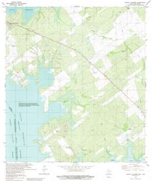
Arroyo Clareno Topo Map Texas
To zoom in, hover over the map of Arroyo Clareno
USGS Topo Quad 26099g2 - 1:24,000 scale
| Topo Map Name: | Arroyo Clareno |
| USGS Topo Quad ID: | 26099g2 |
| Print Size: | ca. 21 1/4" wide x 27" high |
| Southeast Coordinates: | 26.75° N latitude / 99.125° W longitude |
| Map Center Coordinates: | 26.8125° N latitude / 99.1875° W longitude |
| U.S. State: | TX |
| Filename: | o26099g2.jpg |
| Download Map JPG Image: | Arroyo Clareno topo map 1:24,000 scale |
| Map Type: | Topographic |
| Topo Series: | 7.5´ |
| Map Scale: | 1:24,000 |
| Source of Map Images: | United States Geological Survey (USGS) |
| Alternate Map Versions: |
Arroyo Clareno TX 2010 Download PDF Buy paper map Arroyo Clareno TX 2012 Download PDF Buy paper map Arroyo Clareno TX 2016 Download PDF Buy paper map |
1:24,000 Topo Quads surrounding Arroyo Clareno
> Back to 26099e1 at 1:100,000 scale
> Back to 26098a1 at 1:250,000 scale
> Back to U.S. Topo Maps home
Arroyo Clareno topo map: Gazetteer
Arroyo Clareno: Populated Places
Alejandrenas elevation 99m 324′Arroyo Clareno: Reservoirs
El Rancho Tank elevation 116m 380′Juanes Tank elevation 128m 419′
Arroyo Clareno: Summits
Loma Blanca elevation 123m 403′Arroyo Clareno: Valleys
Arroyo Clareño elevation 92m 301′Arroyo Leon elevation 92m 301′
Arroyo Melones elevation 93m 305′
Green Valley elevation 98m 321′
Arroyo Clareno digital topo map on disk
Buy this Arroyo Clareno topo map showing relief, roads, GPS coordinates and other geographical features, as a high-resolution digital map file on DVD:


