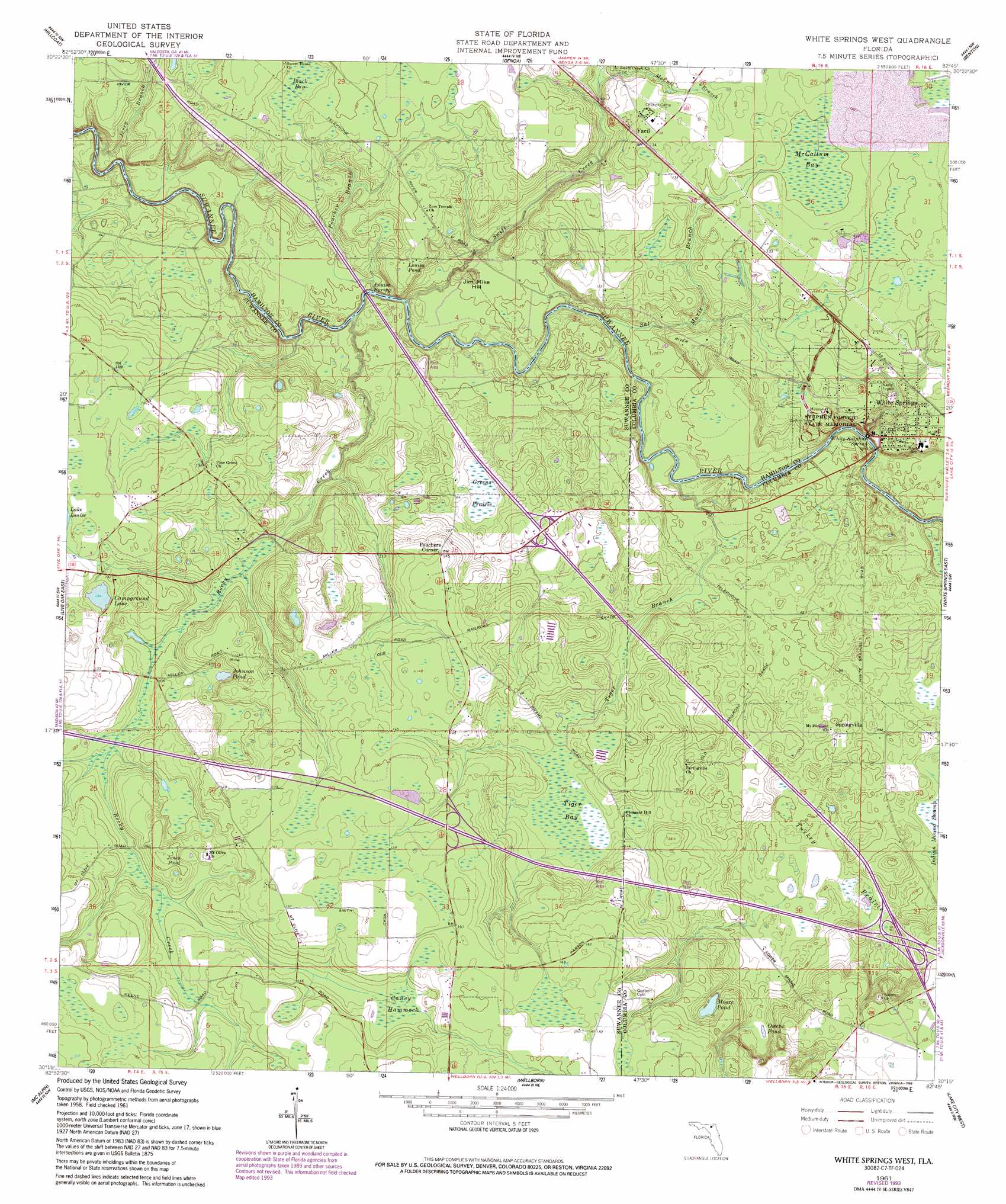
White Springs West Topo Map Florida
To zoom in, hover over the map of White Springs West
USGS Topo Quad 30082c7 - 1:24,000 scale
| Topo Map Name: | White Springs West |
| USGS Topo Quad ID: | 30082c7 |
| Print Size: | ca. 21 1/4" wide x 27" high |
| Southeast Coordinates: | 30.25° N latitude / 82.75° W longitude |
| Map Center Coordinates: | 30.3125° N latitude / 82.8125° W longitude |
| U.S. State: | FL |
| Filename: | O30082C7.jpg |
| Download Map JPG Image: | White Springs West topo map 1:24,000 scale |
| Map Type: | Topographic |
| Topo Series: | 7.5´ |
| Map Scale: | 1:24,000 |
| Source of Map Images: | United States Geological Survey (USGS) |
| Alternate Map Versions: |
White Springs West FL 1961, updated 1963 Download PDF Buy paper map White Springs West FL 1961, updated 1987 Download PDF Buy paper map White Springs West FL 1961, updated 1993 Download PDF Buy paper map White Springs West FL 2012 Download PDF Buy paper map White Springs West FL 2015 Download PDF Buy paper map |
1:24,000 Topo Quads surrounding White Springs West
Jennings |
Jasper |
Cypress Creek |
Fargo Sw |
Council |
Fort Union |
Hillcoat |
Genoa |
Benton |
Fairview |
Live Oak West |
Live Oak East |
White Springs West |
White Springs East |
Deep Creek |
Mayo Ne |
Mcalpin |
Wellborn |
Lake City West |
Lake City East |
Mayo Se |
O'Brien |
O'Brien Se |
Columbia |
Ellisville |
> Back to 30082a1 at 1:100,000 scale
> Back to 30082a1 at 1:250,000 scale
> Back to U.S. Topo Maps home
White Springs West topo map: Gazetteer
White Springs West: Bridges
J Graham Black-Joseph W McAlpin Bridge elevation 33m 108′White Springs West: Lakes
Button Bush Pond (historical) elevation 26m 85′Campground Lake elevation 41m 134′
Johnson Pond elevation 33m 108′
Jones Pond elevation 40m 131′
Lane Pond elevation 39m 127′
Louisa Pond elevation 34m 111′
Moore Pond elevation 37m 121′
Owens Pond elevation 31m 101′
Pasture Pond (historical) elevation 22m 72′
Sailor Hole (historical) elevation 22m 72′
Sistrunk Pond (historical) elevation 42m 137′
White Springs West: Parks
Stephen Foster Folk Culture Center State Park elevation 36m 118′White Springs West: Populated Places
Facil elevation 42m 137′Pouchers Corner elevation 44m 144′
Springville elevation 29m 95′
White Springs elevation 34m 111′
White Springs West: Post Offices
White Springs Post Office elevation 37m 121′White Springs West: Reservoirs
Jackson Pond elevation 33m 108′White Springs West: Springs
Louisa Spring elevation 21m 68′White Sulphur Spring elevation 15m 49′
White Springs West: Streams
Jerry Branch elevation 15m 49′McCall Branch elevation 28m 91′
Poucher Branch elevation 21m 68′
Rocky Creek elevation 15m 49′
Sal Marie Branch elevation 15m 49′
Swift Creek elevation 15m 49′
Tiger Branch elevation 15m 49′
White Springs West: Summits
Jim Mike Hill elevation 24m 78′White Springs West: Swamps
Black Bay elevation 34m 111′Caney Hammock elevation 43m 141′
Greens Prairie elevation 23m 75′
McCallum Bay elevation 37m 121′
Tiger Bay elevation 31m 101′
Turkey Prairie elevation 23m 75′
White Springs West digital topo map on disk
Buy this White Springs West topo map showing relief, roads, GPS coordinates and other geographical features, as a high-resolution digital map file on DVD: