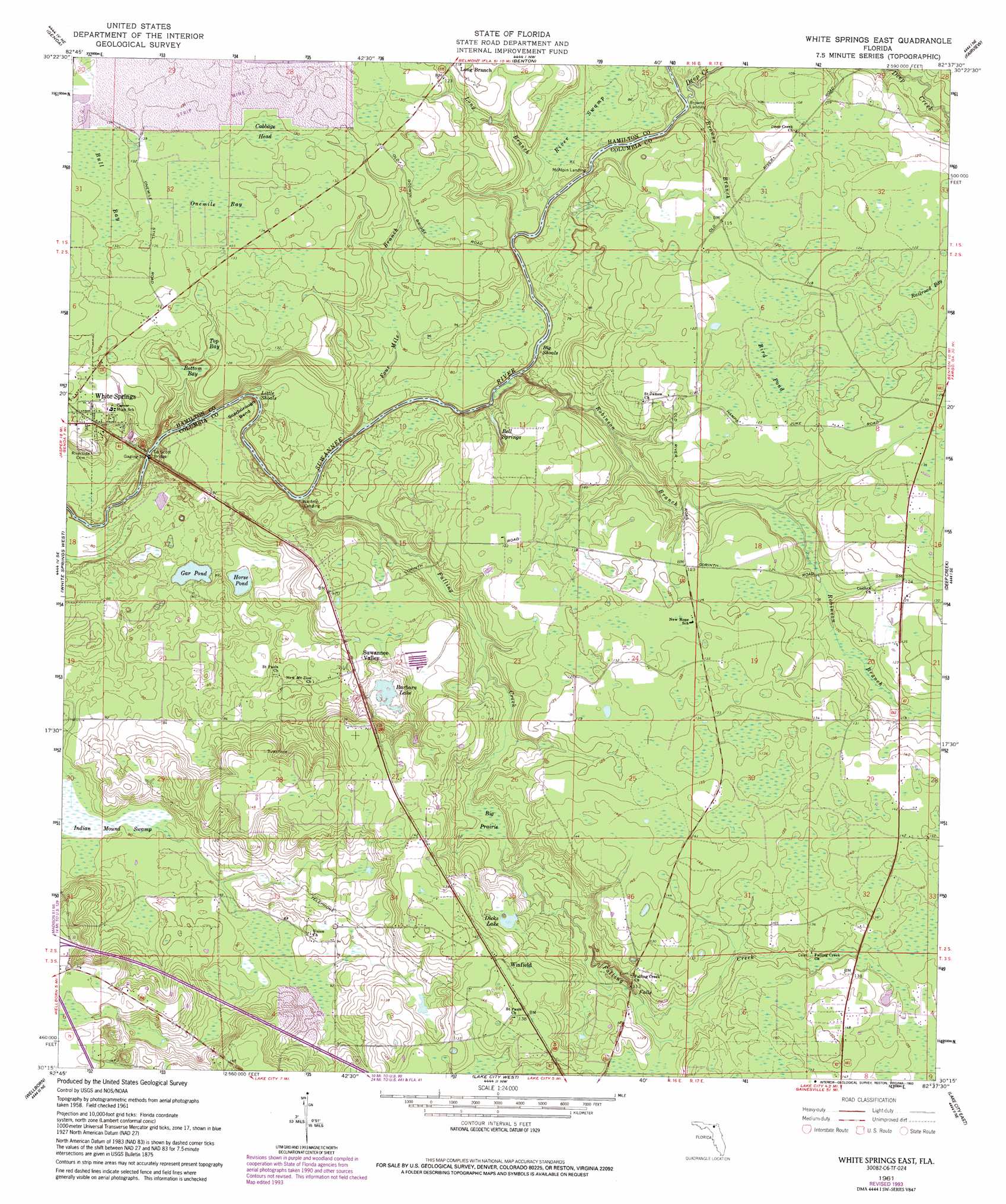
White Springs East Topo Map Florida
To zoom in, hover over the map of White Springs East
USGS Topo Quad 30082c6 - 1:24,000 scale
| Topo Map Name: | White Springs East |
| USGS Topo Quad ID: | 30082c6 |
| Print Size: | ca. 21 1/4" wide x 27" high |
| Southeast Coordinates: | 30.25° N latitude / 82.625° W longitude |
| Map Center Coordinates: | 30.3125° N latitude / 82.6875° W longitude |
| U.S. State: | FL |
| Filename: | O30082C6.jpg |
| Download Map JPG Image: | White Springs East topo map 1:24,000 scale |
| Map Type: | Topographic |
| Topo Series: | 7.5´ |
| Map Scale: | 1:24,000 |
| Source of Map Images: | United States Geological Survey (USGS) |
| Alternate Map Versions: |
White Springs East FL 1961, updated 1963 Download PDF Buy paper map White Springs East FL 1961, updated 1975 Download PDF Buy paper map White Springs East FL 1961, updated 1993 Download PDF Buy paper map White Springs East FL 2012 Download PDF Buy paper map White Springs East FL 2015 Download PDF Buy paper map |
| FStopo: | US Forest Service topo White Springs East is available: Download FStopo PDF Download FStopo TIF |
1:24,000 Topo Quads surrounding White Springs East
Jasper |
Cypress Creek |
Fargo Sw |
Council |
Sargent |
Hillcoat |
Genoa |
Benton |
Fairview |
Sanderson Nw |
Live Oak East |
White Springs West |
White Springs East |
Deep Creek |
Big Gum Swamp |
Mcalpin |
Wellborn |
Lake City West |
Lake City East |
Olustee |
O'Brien |
O'Brien Se |
Columbia |
Ellisville |
Lulu |
> Back to 30082a1 at 1:100,000 scale
> Back to 30082a1 at 1:250,000 scale
> Back to U.S. Topo Maps home
White Springs East topo map: Gazetteer
White Springs East: Bars
Big Shoals elevation 24m 78′Little Shoals elevation 19m 62′
White Springs East: Bends
Scarborough Bend elevation 24m 78′White Springs East: Bridges
Ed Scott Bridge elevation 23m 75′White Springs East: Lakes
Barbara Lake elevation 23m 75′Dicks Lake elevation 37m 121′
Gar Pond elevation 22m 72′
Horse Pond elevation 22m 72′
White Springs East: Parks
Big Shoals State Park elevation 21m 68′White Springs East: Populated Places
Long Branch elevation 38m 124′Suwannee Valley elevation 31m 101′
Winfield elevation 43m 141′
White Springs East: Springs
Bell Springs elevation 34m 111′White Springs East: Streams
Browns Branch elevation 24m 78′Deep Creek elevation 23m 75′
Falling Creek elevation 31m 101′
Falling Creek elevation 20m 65′
Four Mile Branch elevation 24m 78′
Long Branch elevation 26m 85′
Robinson Creek elevation 27m 88′
White Springs East: Swamps
Big Prairie elevation 28m 91′Bird Pond elevation 35m 114′
Bottom Bay elevation 31m 101′
Bull Bay elevation 39m 127′
Cabbage Head elevation 39m 127′
Indian Mound Swamp elevation 23m 75′
Onemile Bay elevation 40m 131′
Railroad Bay elevation 36m 118′
River Swamp elevation 25m 82′
Top Bay elevation 36m 118′
White Springs East digital topo map on disk
Buy this White Springs East topo map showing relief, roads, GPS coordinates and other geographical features, as a high-resolution digital map file on DVD: