Sugartown Topo Map Louisiana
To zoom in, hover over the map of Sugartown
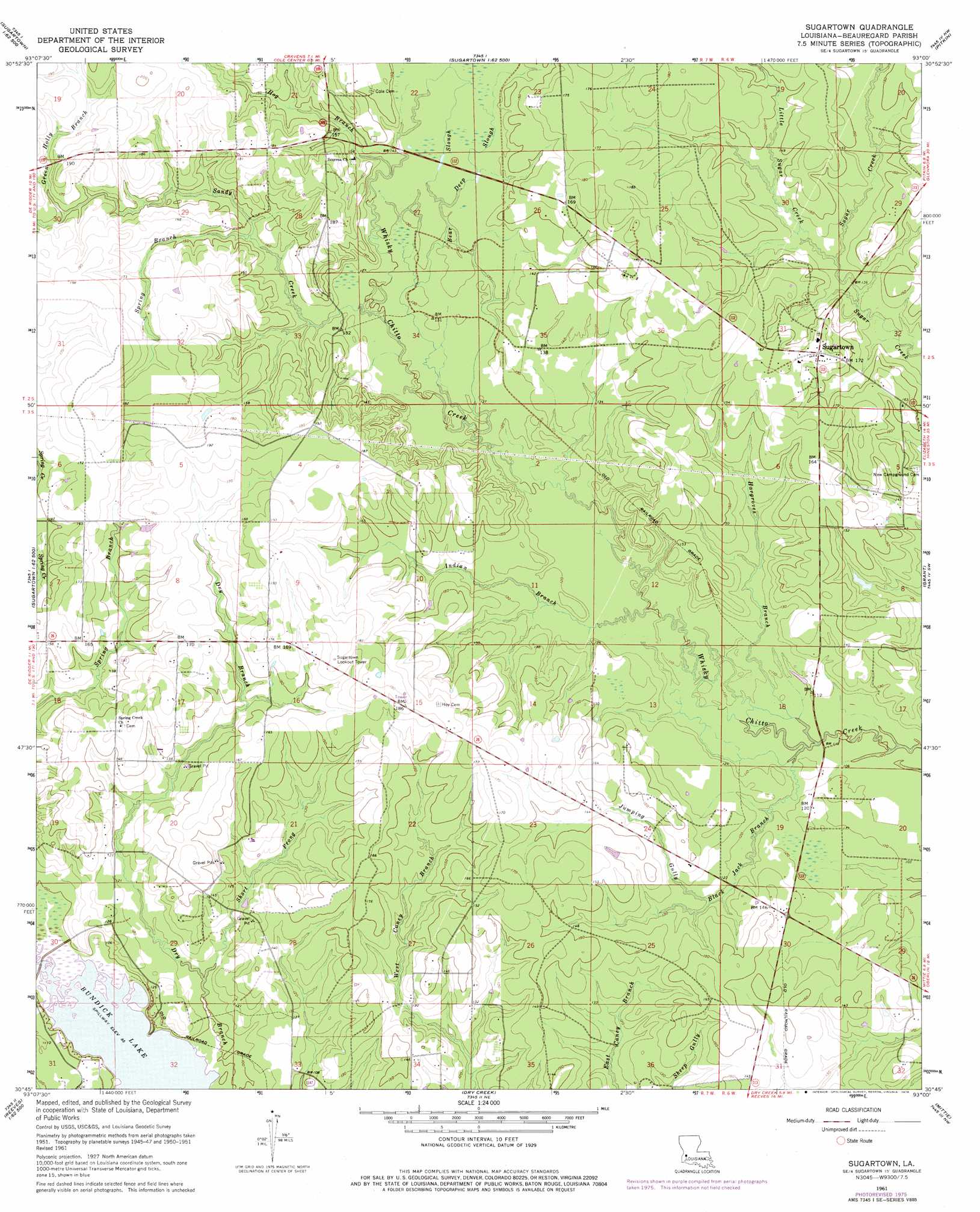
USGS Topo Quad 30093g1 - 1:24,000 scale
| Topo Map Name: | Sugartown |
| USGS Topo Quad ID: | 30093g1 |
| Print Size: | ca. 21 1/4" wide x 27" high |
| Southeast Coordinates: | 30.75° N latitude / 93° W longitude |
| Map Center Coordinates: | 30.8125° N latitude / 93.0625° W longitude |
| U.S. State: | LA |
| Filename: | o30093g1.jpg |
| Download Map JPG Image: | Sugartown topo map 1:24,000 scale |
| Map Type: | Topographic |
| Topo Series: | 7.5´ |
| Map Scale: | 1:24,000 |
| Source of Map Images: | United States Geological Survey (USGS) |
| Alternate Map Versions: |
Sugartown LA 1951, updated 1952 Download PDF Buy paper map Sugartown LA 1961, updated 1963 Download PDF Buy paper map Sugartown LA 1961, updated 1976 Download PDF Buy paper map Sugartown LA 2012 Download PDF Buy paper map Sugartown LA 2015 Download PDF Buy paper map |
1:24,000 Topo Quads surrounding Sugartown
Newllano |
Fort Polk |
Birds Creek |
Fullerton Lake |
Afeman |
Rose Pine |
Hurricane Branch |
Sugrue |
Pitkin |
Steep Gully |
De Ridder |
Boneset Creek |
Sugartown |
Grant |
Elizabeth |
Mach Branch |
Redhead Branch |
Dry Creek |
Mittie |
Pine Chapel |
Kernan |
Longville |
Reeves |
Le Blanc |
Oberlin |
> Back to 30093e1 at 1:100,000 scale
> Back to 30092a1 at 1:250,000 scale
> Back to U.S. Topo Maps home
Sugartown topo map: Gazetteer
Sugartown: Guts
Little Sugar Creek elevation 39m 127′Sugartown: Pillars
Sugartown Lookout Tower elevation 56m 183′Sugartown: Populated Places
Baggett (historical) elevation 39m 127′Hoy (historical) elevation 53m 173′
Kipling elevation 34m 111′
Sugartown elevation 54m 177′
Sugartown: Post Offices
Sugartown Post Office elevation 52m 170′Sugartown: Streams
Bear Slough elevation 37m 121′Black Jack Branch elevation 32m 104′
Deep Slough elevation 39m 127′
Green Holly Branch elevation 46m 150′
Hargroves Branch elevation 29m 95′
Horse Branch elevation 40m 131′
Indian Branch elevation 32m 104′
Jumping Gully elevation 36m 118′
Sandy Creek elevation 37m 121′
Short Prong elevation 31m 101′
Spring Branch elevation 43m 141′
Sugartown digital topo map on disk
Buy this Sugartown topo map showing relief, roads, GPS coordinates and other geographical features, as a high-resolution digital map file on DVD: