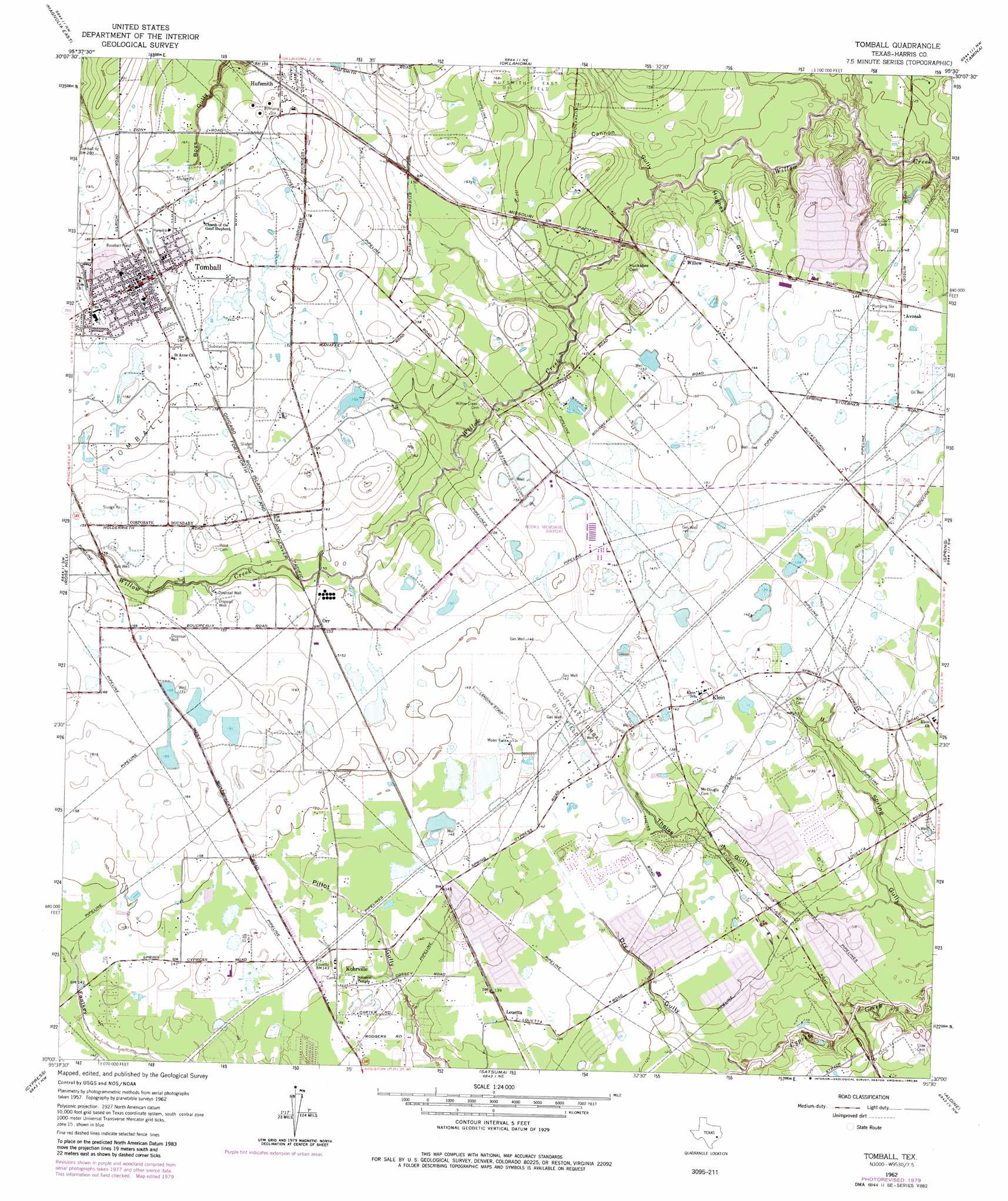
Tomball Topo Map Texas
To zoom in, hover over the map of Tomball
USGS Topo Quad 30095a5 - 1:24,000 scale
| Topo Map Name: | Tomball |
| USGS Topo Quad ID: | 30095a5 |
| Print Size: | ca. 21 1/4" wide x 27" high |
| Southeast Coordinates: | 30° N latitude / 95.5° W longitude |
| Map Center Coordinates: | 30.0625° N latitude / 95.5625° W longitude |
| U.S. State: | TX |
| Filename: | o30095a5.jpg |
| Download Map JPG Image: | Tomball topo map 1:24,000 scale |
| Map Type: | Topographic |
| Topo Series: | 7.5´ |
| Map Scale: | 1:24,000 |
| Source of Map Images: | United States Geological Survey (USGS) |
| Alternate Map Versions: |
Louetta TX 1916 Download PDF Buy paper map Tomball TX 1962, updated 1964 Download PDF Buy paper map Tomball TX 1962, updated 1974 Download PDF Buy paper map Tomball TX 1962, updated 1980 Download PDF Buy paper map Tomball TX 1962, updated 1984 Download PDF Buy paper map Tomball TX 1995, updated 1999 Download PDF Buy paper map Tomball TX 2010 Download PDF Buy paper map Tomball TX 2013 Download PDF Buy paper map Tomball TX 2016 Download PDF Buy paper map |
1:24,000 Topo Quads surrounding Tomball
Plantersville |
Keenan |
Cowl Spur |
Conroe |
Cut And Shoot |
Magnolia West |
Magnolia East |
Oklahoma |
Tamina |
Outlaw Pond |
Hockley |
Rose Hill |
Tomball |
Spring |
Maedan |
Warren Lake |
Cypress |
Satsuma |
Aldine |
Humble |
Katy |
Addicks |
Hedwig Village |
Houston Heights |
Settegast |
> Back to 30095a1 at 1:100,000 scale
> Back to 30094a1 at 1:250,000 scale
> Back to U.S. Topo Maps home
Tomball topo map: Gazetteer
Tomball: Airports
David Wayne Hooks Memorial Airport elevation 46m 150′Helicopter Express Heliport elevation 46m 150′
Strack Farms Heliport elevation 38m 124′
Tomball Regional Hospital Heliport elevation 57m 187′
Tomball: Oilfields
Southeast Tomball Oil Field elevation 44m 144′Tomball: Parks
Cypresswood Park elevation 32m 104′Elizabeth Kaiser Meyer Park elevation 34m 111′
Klein Memorial Stadium elevation 38m 124′
Tomball Concordia Lutheran Stadium elevation 55m 180′
Tomball: Populated Places
Albury Manor elevation 47m 154′Avonak elevation 44m 144′
Bridgestone West elevation 41m 134′
Canyongate elevation 51m 167′
Charterwood elevation 40m 131′
Five Oaks elevation 42m 137′
Hufsmith elevation 52m 170′
Klein elevation 43m 141′
Kohrville elevation 43m 141′
Londonderry elevation 42m 137′
Louetta elevation 43m 141′
Northampton Forest elevation 44m 144′
Northpointe East elevation 49m 160′
Oakwood Glen elevation 37m 121′
Pinewood Place elevation 44m 144′
Shannon Forest elevation 42m 137′
Spring Creek Forest elevation 40m 131′
Three Lakes East elevation 49m 160′
Tomball elevation 57m 187′
Waldenwood elevation 49m 160′
Wellington elevation 44m 144′
Westbourne elevation 48m 157′
Willow elevation 45m 147′
Willow Forest elevation 42m 137′
Wimbledon Champions elevation 32m 104′
Wimbledon Country elevation 44m 144′
Wimbledon Estates elevation 35m 114′
Tomball: Post Offices
Hufsmith Post Office elevation 50m 164′Tomball: Valleys
Cannon Gully elevation 35m 114′Dry Gully elevation 31m 101′
Hughes Gully elevation 35m 114′
Pillot Gully elevation 36m 118′
Theiss Gully elevation 32m 104′
Tomball digital topo map on disk
Buy this Tomball topo map showing relief, roads, GPS coordinates and other geographical features, as a high-resolution digital map file on DVD: