Ludowici Topo Map Georgia
To zoom in, hover over the map of Ludowici
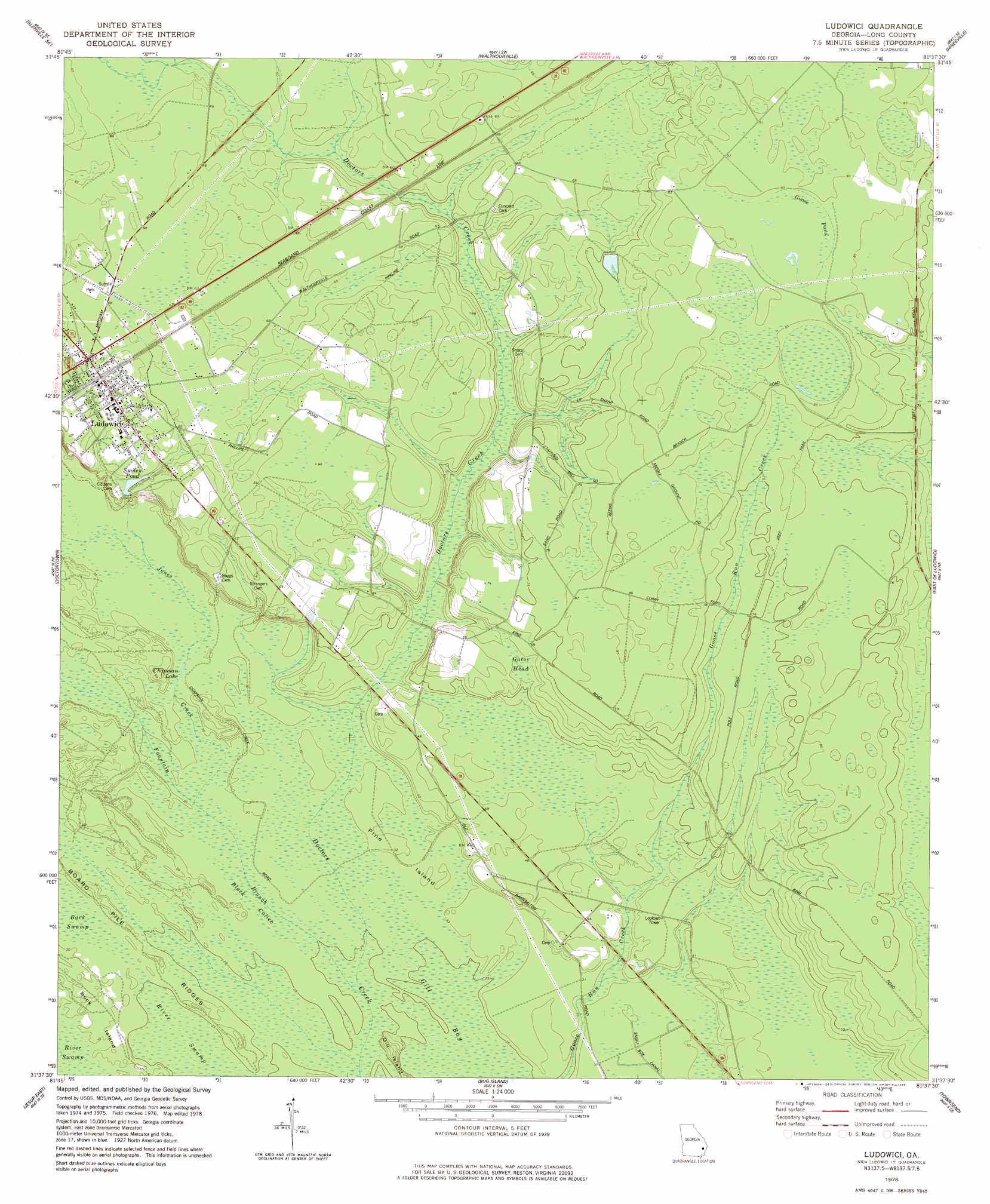
USGS Topo Quad 31081f6 - 1:24,000 scale
| Topo Map Name: | Ludowici |
| USGS Topo Quad ID: | 31081f6 |
| Print Size: | ca. 21 1/4" wide x 27" high |
| Southeast Coordinates: | 31.625° N latitude / 81.625° W longitude |
| Map Center Coordinates: | 31.6875° N latitude / 81.6875° W longitude |
| U.S. State: | GA |
| Filename: | o31081f6.jpg |
| Download Map JPG Image: | Ludowici topo map 1:24,000 scale |
| Map Type: | Topographic |
| Topo Series: | 7.5´ |
| Map Scale: | 1:24,000 |
| Source of Map Images: | United States Geological Survey (USGS) |
| Alternate Map Versions: |
Ludowici GA 1978, updated 1978 Download PDF Buy paper map Ludowici GA 2011 Download PDF Buy paper map Ludowici GA 2014 Download PDF Buy paper map |
1:24,000 Topo Quads surrounding Ludowici
Glennville |
Glennville Ne |
Taylors Creek |
Trinity |
Limerick Nw |
Glennville Sw |
Glennville Se |
Walthourville |
Hinesville |
Dorchester |
Jesup Nw |
Doctortown |
Ludowici |
East Of Ludowici |
Riceboro |
Jesup West |
Jesup East |
Bug Island |
Townsend |
Eulonia |
Mckinnon |
Manningtown |
Everett |
Cox |
Ridgeville |
> Back to 31081e1 at 1:100,000 scale
> Back to 31080a1 at 1:250,000 scale
> Back to U.S. Topo Maps home
Ludowici topo map: Gazetteer
Ludowici: Bridges
Ivy Melvin Hendrix Junior Bridge elevation 15m 49′Ludowici: Dams
Smiley Pond Dam elevation 15m 49′Ludowici: Islands
Buck Island elevation 10m 32′Gill Island elevation 12m 39′
Pine Island elevation 9m 29′
Ludowici: Lakes
Chapman Lake elevation 10m 32′Ludowici: Populated Places
Brewer (historical) elevation 21m 68′Ludowici elevation 20m 65′
Ludowici: Post Offices
Ludowici Post Office elevation 20m 65′Ludowici: Reservoirs
Smiley Pond elevation 15m 49′Ludowici: Ridges
Board Pile Ridges elevation 9m 29′Ludowici: Streams
Fountain Branch elevation 7m 22′Jones Creek elevation 8m 26′
Little Doctor Creek elevation 18m 59′
Ludowici: Swamps
Black Calico elevation 8m 26′Gator Head elevation 18m 59′
Gill Bay elevation 7m 22′
Goose Pond elevation 27m 88′
Ludowici digital topo map on disk
Buy this Ludowici topo map showing relief, roads, GPS coordinates and other geographical features, as a high-resolution digital map file on DVD: