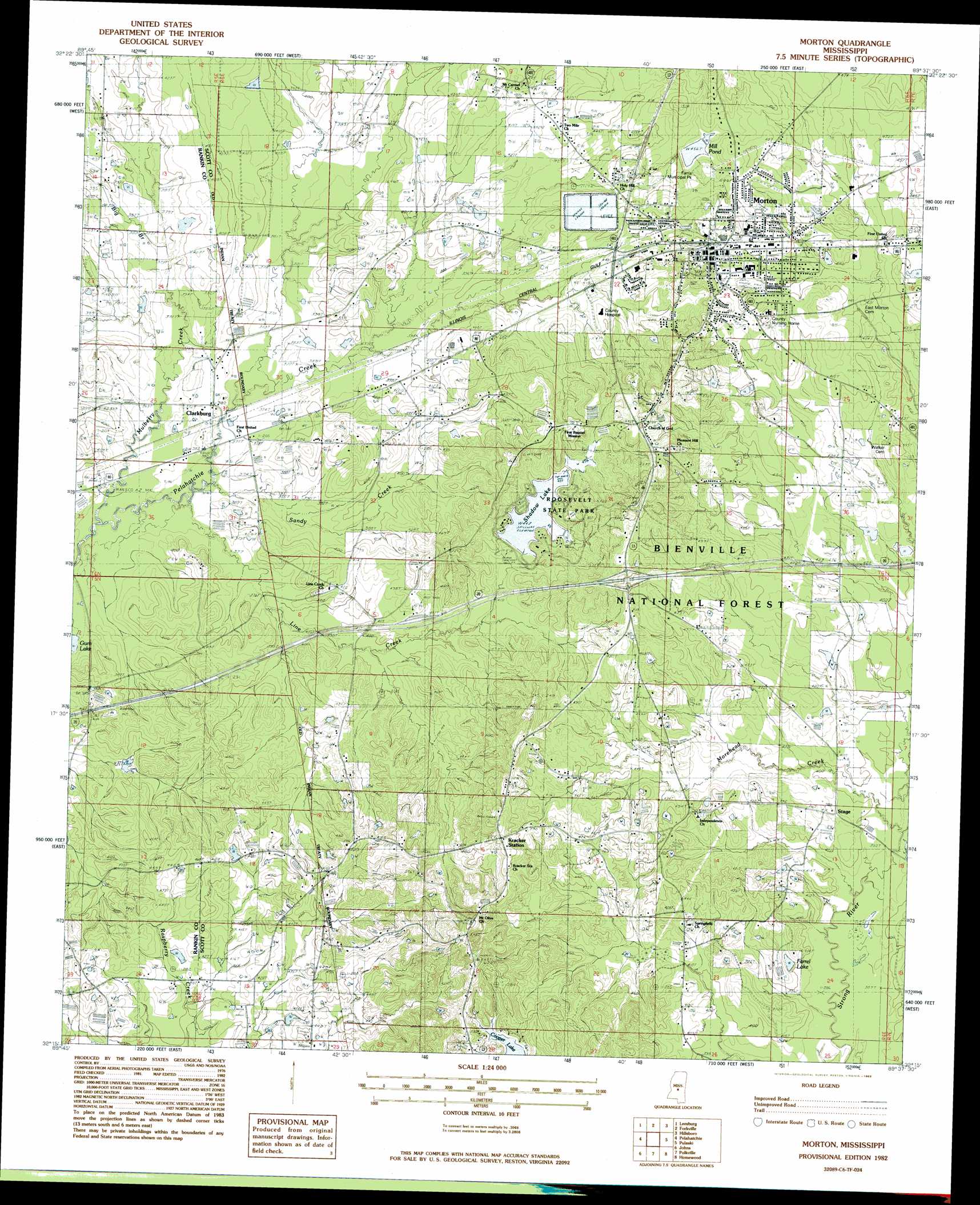
Morton Topo Map Mississippi
To zoom in, hover over the map of Morton
USGS Topo Quad 32089c6 - 1:24,000 scale
| Topo Map Name: | Morton |
| USGS Topo Quad ID: | 32089c6 |
| Print Size: | ca. 21 1/4" wide x 27" high |
| Southeast Coordinates: | 32.25° N latitude / 89.625° W longitude |
| Map Center Coordinates: | 32.3125° N latitude / 89.6875° W longitude |
| U.S. State: | MS |
| Filename: | o32089c6.jpg |
| Download Map JPG Image: | Morton topo map 1:24,000 scale |
| Map Type: | Topographic |
| Topo Series: | 7.5´ |
| Map Scale: | 1:24,000 |
| Source of Map Images: | United States Geological Survey (USGS) |
| Alternate Map Versions: |
Morton MS 1982, updated 1983 Download PDF Buy paper map Morton MS 1982, updated 1983 Download PDF Buy paper map Morton MS 2012 Download PDF Buy paper map Morton MS 2015 Download PDF Buy paper map |
| FStopo: | US Forest Service topo Morton is available: Download FStopo PDF Download FStopo TIF |
1:24,000 Topo Quads surrounding Morton
Shoccoe |
Sharon Se |
Ludlow |
Lena |
Walnut Grove |
Goshen Springs |
Leesburg |
Forkville |
Hillsboro |
Harperville |
Brandon |
Pelahatchie |
Morton |
Pulaski |
Forest |
Puckett Nw |
Johns |
Polkville |
Homewood |
Pineville |
Braxton |
Puckett |
White Oak |
Raleigh |
Louin Sw |
> Back to 32089a1 at 1:100,000 scale
> Back to 32088a1 at 1:250,000 scale
> Back to U.S. Topo Maps home
Morton topo map: Gazetteer
Morton: Crossings
Interchange 77 elevation 151m 495′Morton: Dams
A B Farris Pond Dam elevation 143m 469′B Jones Pond Dam elevation 125m 410′
Jack Stewart Lake Dam elevation 114m 374′
Jack Stewart Pond Dam elevation 138m 452′
Morton Waste Stabilization Ponds Dam elevation 133m 436′
Roosevelt State Park Lake Dam elevation 127m 416′
Morton: Lakes
Farrel Lake elevation 118m 387′Morton: Parks
Farris Municipal Park elevation 144m 472′Roosevelt State Park elevation 155m 508′
Morton: Populated Places
Clarkburg elevation 114m 374′Independence elevation 140m 459′
Kracker Station elevation 175m 574′
Morton elevation 144m 472′
Stage elevation 124m 406′
Morton: Reservoirs
Mill Pond elevation 139m 456′Shadow Lake elevation 133m 436′
Morton: Streams
Big Branch elevation 115m 377′Line Creek elevation 108m 354′
Mulberry Creek elevation 111m 364′
Sandy Creek elevation 110m 360′
Morton digital topo map on disk
Buy this Morton topo map showing relief, roads, GPS coordinates and other geographical features, as a high-resolution digital map file on DVD:
Gulf Coast (LA, MS, AL, FL) & Southwestern Georgia
Buy digital topo maps: Gulf Coast (LA, MS, AL, FL) & Southwestern Georgia
 & Southwestern Georgia map DVD")