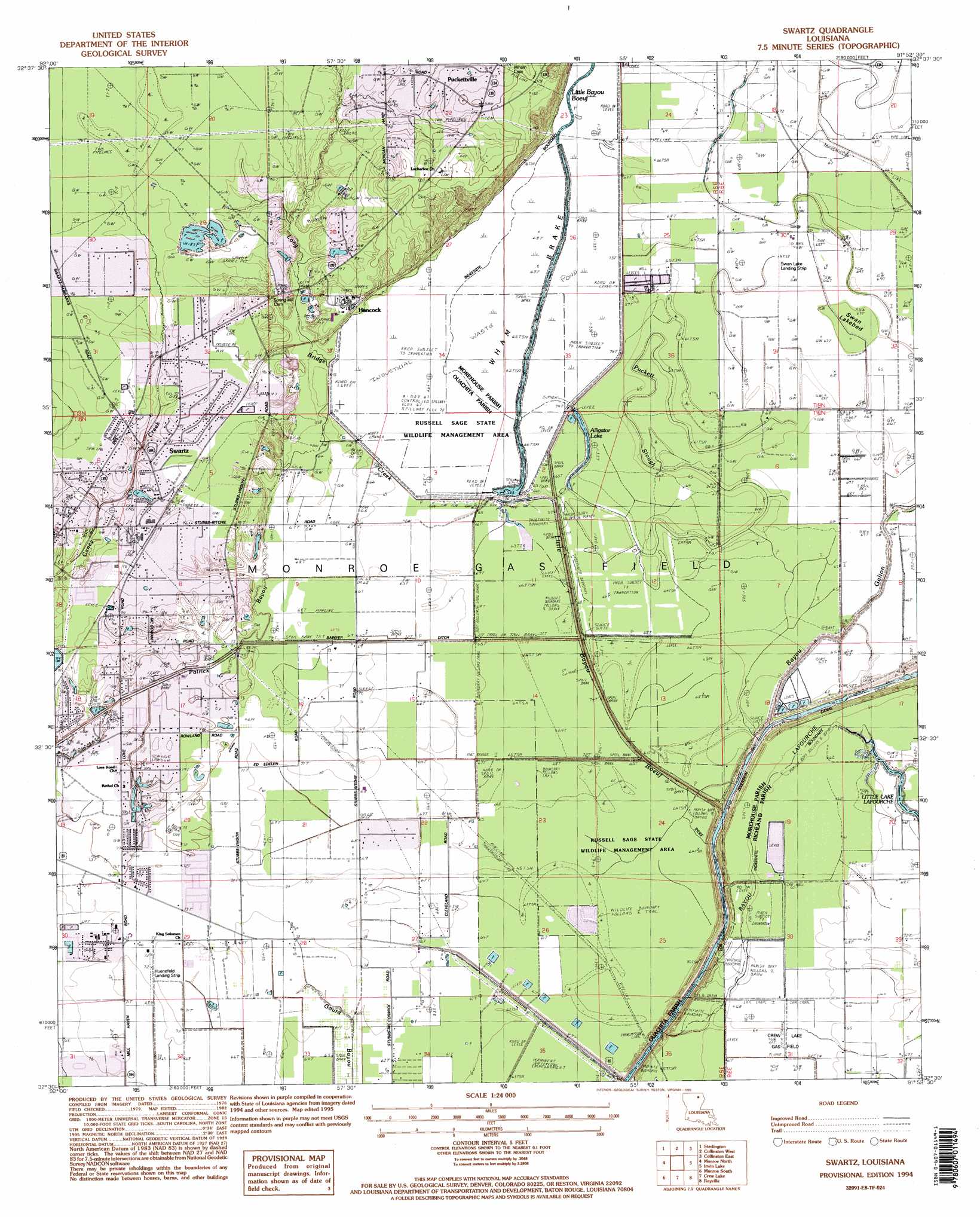
Swartz Topo Map Louisiana
To zoom in, hover over the map of Swartz
USGS Topo Quad 32091e8 - 1:24,000 scale
| Topo Map Name: | Swartz |
| USGS Topo Quad ID: | 32091e8 |
| Print Size: | ca. 21 1/4" wide x 27" high |
| Southeast Coordinates: | 32.5° N latitude / 91.875° W longitude |
| Map Center Coordinates: | 32.5625° N latitude / 91.9375° W longitude |
| U.S. State: | LA |
| Filename: | o32091e8.jpg |
| Download Map JPG Image: | Swartz topo map 1:24,000 scale |
| Map Type: | Topographic |
| Topo Series: | 7.5´ |
| Map Scale: | 1:24,000 |
| Source of Map Images: | United States Geological Survey (USGS) |
| Alternate Map Versions: |
Swartz LA 1982, updated 1983 Download PDF Buy paper map Swartz LA 1994, updated 1995 Download PDF Buy paper map Swartz LA 2012 Download PDF Buy paper map Swartz LA 2015 Download PDF Buy paper map |
1:24,000 Topo Quads surrounding Swartz
Haille |
Harrell Lake |
Bastrop |
Mer Rouge |
Bonita Sw |
Rocky Branch |
Sterlington |
Collinston West |
Collinston East |
Whitney Island North |
West Monroe North |
Monroe North |
Swartz |
Irwin Lake |
Whitney Island South |
West Monroe South |
Monroe South |
Crew Lake |
Rayville |
Bee Bayou |
Luna |
Bosco |
Gilleyville |
Mangham |
Baskinton |
> Back to 32091e1 at 1:100,000 scale
> Back to 32090a1 at 1:250,000 scale
> Back to U.S. Topo Maps home
Swartz topo map: Gazetteer
Swartz: Airports
Huenefeld Airport elevation 21m 68′Swan Lake Landing Strip elevation 20m 65′
Swartz: Canals
Sawyer Ditch elevation 19m 62′Swartz: Flats
Swan Lakebed elevation 19m 62′Swartz: Guts
Patrick Bayou elevation 19m 62′Swartz: Lakes
Alligator Lake elevation 19m 62′Spicewood Pond (historical) elevation 18m 59′
Swan Lake (historical) elevation 19m 62′
Swartz: Oilfields
Crew Lake Gas Field elevation 19m 62′North Crew Lake Gas Field elevation 19m 62′
Swartz: Parks
Russell Sage State Wildlife Management Area elevation 18m 59′Swartz: Populated Places
Audubon Park elevation 29m 95′County Acres elevation 29m 95′
Eastwood Estates elevation 25m 82′
Fleetwood Park elevation 23m 75′
Hancock elevation 23m 75′
Hidden Oaks elevation 29m 95′
Lakewood Estates elevation 29m 95′
Love Estates elevation 23m 75′
Milhaven Estates elevation 21m 68′
Puckettville elevation 33m 108′
Quail Creek Estates elevation 29m 95′
Swartz elevation 28m 91′
Town East elevation 22m 72′
Swartz: Streams
Bayou Galion elevation 12m 39′Little Bayou Boeuf elevation 14m 45′
Long Bridge Creek elevation 19m 62′
Puckett Slough elevation 19m 62′
Swartz: Swamps
Wham Brake elevation 20m 65′Swartz digital topo map on disk
Buy this Swartz topo map showing relief, roads, GPS coordinates and other geographical features, as a high-resolution digital map file on DVD: