Duster Topo Map Texas
To zoom in, hover over the map of Duster
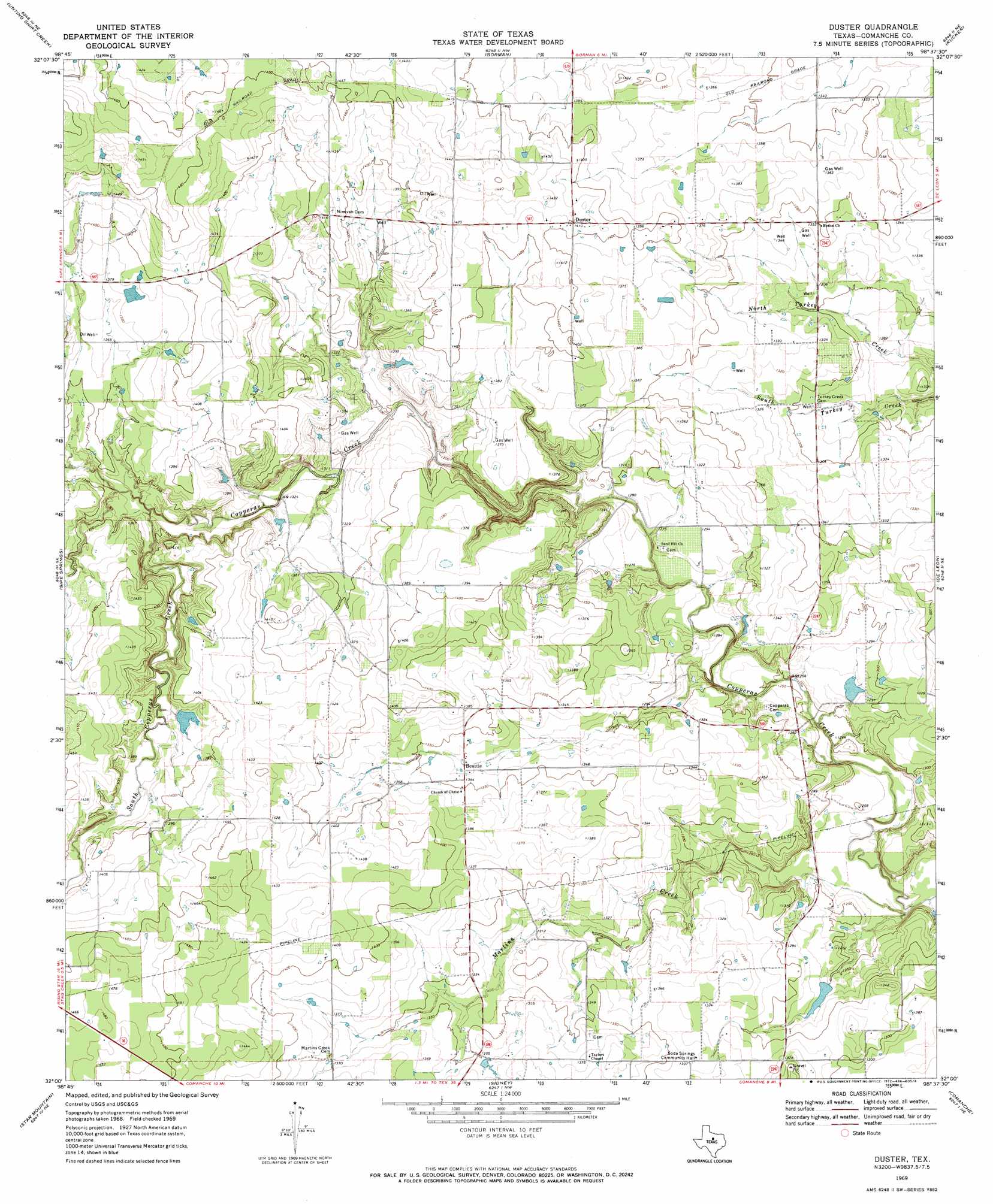
USGS Topo Quad 32098a6 - 1:24,000 scale
| Topo Map Name: | Duster |
| USGS Topo Quad ID: | 32098a6 |
| Print Size: | ca. 21 1/4" wide x 27" high |
| Southeast Coordinates: | 32° N latitude / 98.625° W longitude |
| Map Center Coordinates: | 32.0625° N latitude / 98.6875° W longitude |
| U.S. State: | TX |
| Filename: | o32098a6.jpg |
| Download Map JPG Image: | Duster topo map 1:24,000 scale |
| Map Type: | Topographic |
| Topo Series: | 7.5´ |
| Map Scale: | 1:24,000 |
| Source of Map Images: | United States Geological Survey (USGS) |
| Alternate Map Versions: |
Duster TX 1969, updated 1972 Download PDF Buy paper map Duster TX 2010 Download PDF Buy paper map Duster TX 2012 Download PDF Buy paper map Duster TX 2016 Download PDF Buy paper map |
1:24,000 Topo Quads surrounding Duster
Cisco South |
Carbon |
Kokomo |
Desdemona |
Huckabay Sw |
Union Center |
Hunting Shirt Creek |
Gorman |
Rucker |
Lingleville |
Rising Star |
Sipe Springs |
Duster |
De Leon |
Comyn |
May |
Star Mountain |
Sidney |
Comanche |
Proctor |
Owens |
Blanket |
Mercers Gap |
Newburg |
Gustine |
> Back to 32098a1 at 1:100,000 scale
> Back to 32098a1 at 1:250,000 scale
> Back to U.S. Topo Maps home
Duster topo map: Gazetteer
Duster: Dams
A T Gilchrest Dam elevation 420m 1377′Bingham Dam elevation 414m 1358′
Charles Taylor Dam elevation 390m 1279′
Donald A Nowlin Dam elevation 422m 1384′
Dutton Dam elevation 406m 1332′
Huddleston Dam A elevation 417m 1368′
Johnny Poynor Dam elevation 373m 1223′
Keith Dam elevation 410m 1345′
Nichols Dam elevation 385m 1263′
Soil Conservation Service Site 4 Dam elevation 407m 1335′
Soil Conservation Service Site 9 Dam elevation 397m 1302′
Soil Conservation Service Site Number 5 Dam elevation 397m 1302′
Weatherby and Womack Dam elevation 410m 1345′
Welch Lake Dam elevation 406m 1332′
Wolfe Pecanlands Lake Number 1 Dam elevation 396m 1299′
Duster: Populated Places
Beattie elevation 408m 1338′Duster elevation 429m 1407′
Duster: Reservoirs
A T Gilchrest Lake elevation 420m 1377′Bingham Lake elevation 414m 1358′
Charles Taylor Reservoir elevation 390m 1279′
Donald A Nowlin Reservoir elevation 422m 1384′
Dutton Lake elevation 406m 1332′
Huddleston Dam A Lake elevation 417m 1368′
Johnny Poynor Lake elevation 373m 1223′
Keith Reservoir elevation 410m 1345′
Nichols Lake elevation 385m 1263′
Soil Conservation Service Site 4 Reservoir elevation 407m 1335′
Soil Conservation Service Site 5 Reservoir elevation 397m 1302′
Soil Conservation Service Site 9 Reservoir elevation 397m 1302′
Weatherby and Womack Lake elevation 410m 1345′
Welch Lake elevation 406m 1332′
Wolfe Pecanlands Lake Number 1 elevation 396m 1299′
Duster: Streams
Martins Creek elevation 369m 1210′South Copperas Creek elevation 400m 1312′
Duster digital topo map on disk
Buy this Duster topo map showing relief, roads, GPS coordinates and other geographical features, as a high-resolution digital map file on DVD: