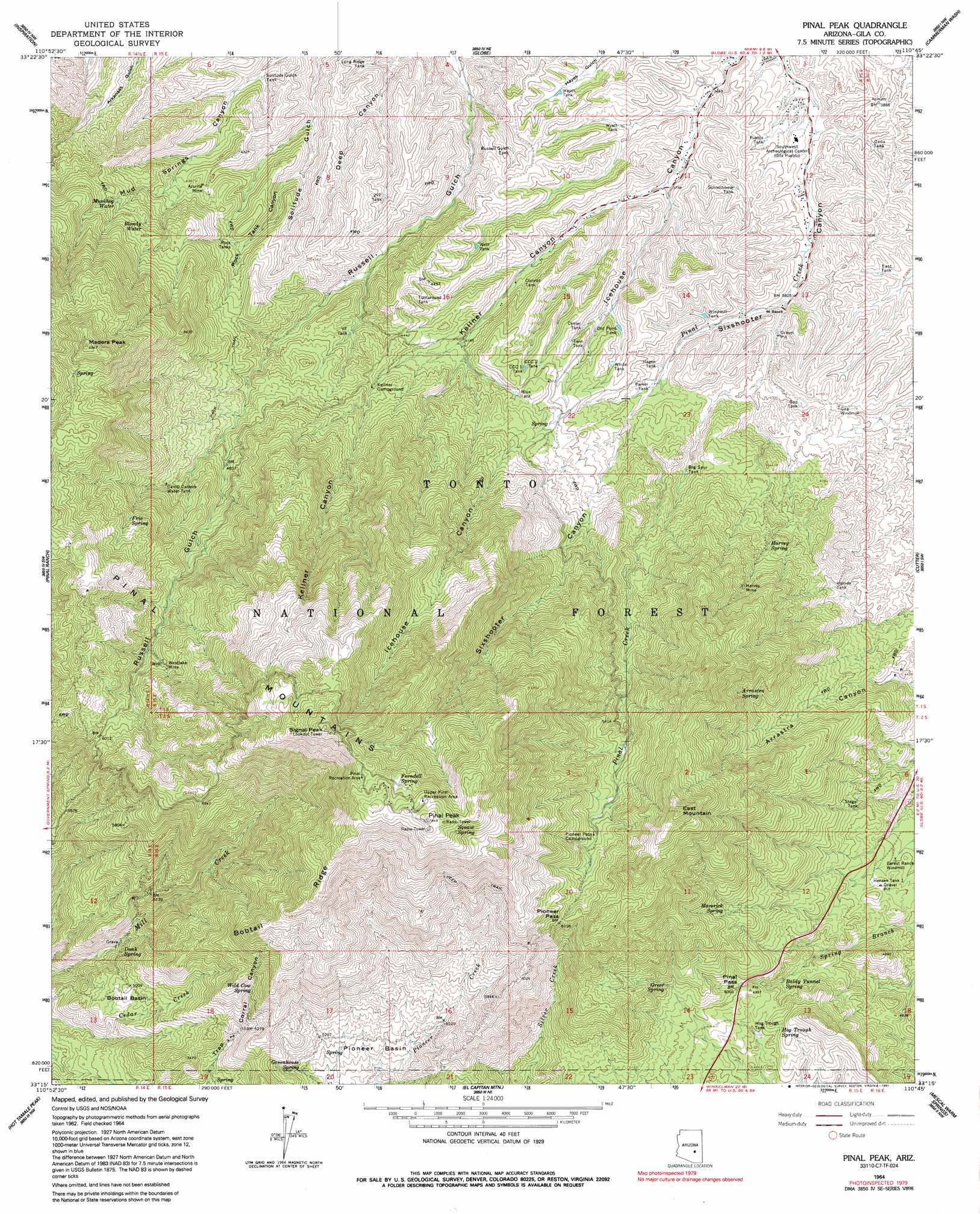
Pinal Peak Topo Map Arizona
To zoom in, hover over the map of Pinal Peak
USGS Topo Quad 33110c7 - 1:24,000 scale
| Topo Map Name: | Pinal Peak |
| USGS Topo Quad ID: | 33110c7 |
| Print Size: | ca. 21 1/4" wide x 27" high |
| Southeast Coordinates: | 33.25° N latitude / 110.75° W longitude |
| Map Center Coordinates: | 33.3125° N latitude / 110.8125° W longitude |
| U.S. State: | AZ |
| Filename: | o33110c7.jpg |
| Download Map JPG Image: | Pinal Peak topo map 1:24,000 scale |
| Map Type: | Topographic |
| Topo Series: | 7.5´ |
| Map Scale: | 1:24,000 |
| Source of Map Images: | United States Geological Survey (USGS) |
| Alternate Map Versions: |
Pinal Peak AZ 1964, updated 1965 Download PDF Buy paper map Pinal Peak AZ 1964, updated 1973 Download PDF Buy paper map Pinal Peak AZ 1964, updated 1991 Download PDF Buy paper map Pinal Peak AZ 1964, updated 1991 Download PDF Buy paper map Pinal Peak AZ 2004, updated 2007 Download PDF Buy paper map Pinal Peak AZ 2011 Download PDF Buy paper map Pinal Peak AZ 2014 Download PDF Buy paper map |
| FStopo: | US Forest Service topo Pinal Peak is available: Download FStopo PDF Download FStopo TIF |
1:24,000 Topo Quads surrounding Pinal Peak
Two Bar Mountain |
Salt River Peak |
Rockinstraw Mountain |
Chrome Butte |
Sevenmile Mountains |
Haunted Canyon |
Inspiration |
Globe |
Cammerman Wash |
Dourine Canyon |
Superior |
Pinal Ranch |
Pinal Peak |
Cutter |
Bucket Mountain |
Teapot Mountain |
Hot Tamale Peak |
El Capitan Mountain |
Mescal Warm Spring |
Coolidge Dam |
Grayback |
Kearny |
Hayden |
Christmas |
Jerusalem Mountain |
> Back to 33110a1 at 1:100,000 scale
> Back to 33110a1 at 1:250,000 scale
> Back to U.S. Topo Maps home
Pinal Peak topo map: Gazetteer
Pinal Peak: Basins
Bobtail Basin elevation 1513m 4963′Pioneer Basin elevation 1539m 5049′
Pinal Peak: Gaps
Pinal Pass elevation 1512m 4960′Pioneer Pass elevation 1881m 6171′
Pinal Peak: Mines
Azurite Mine elevation 1296m 4251′Harvey Mine elevation 1539m 5049′
Westlake Mine elevation 1770m 5807′
Pinal Peak: Parks
Pinal Campground elevation 2305m 7562′Upper Pinal Campground elevation 2348m 7703′
Pinal Peak: Reservoirs
Big Spur Tank elevation 1300m 4265′Blue Tank elevation 1340m 4396′
Camp Carlock Water Tank elevation 1540m 5052′
CCC One Tank elevation 1328m 4356′
CCC Two Tank elevation 1334m 4376′
Cedar Creek Tank elevation 1506m 4940′
Center Tank elevation 1264m 4146′
Convict Tank elevation 1242m 4074′
Daou Tank elevation 1157m 3795′
East Tank elevation 1179m 3868′
Fork Tank elevation 1465m 4806′
Gap Tank elevation 1230m 4035′
Hagen Tank elevation 1242m 4074′
Harvey Tank elevation 1386m 4547′
Hayes Tank elevation 1185m 3887′
Hensen Tank One elevation 1371m 4498′
Hog Trough Tank elevation 1456m 4776′
Long Ridge Tank elevation 1168m 3832′
Old Pond Tank elevation 1248m 4094′
Parker Tank elevation 1248m 4094′
Pueblo Tank elevation 1148m 3766′
Rock Tanks elevation 1324m 4343′
Russell Gulch Tank elevation 1192m 3910′
Schoolhouse Tank elevation 1180m 3871′
Solitude Gulch Tank elevation 1178m 3864′
Stegal Tank elevation 1399m 4589′
Turnaround Tank elevation 1324m 4343′
Twin Tank elevation 1285m 4215′
Two VF Tank elevation 1268m 4160′
VF Tank elevation 1295m 4248′
West Tank elevation 1263m 4143′
White Tank elevation 1279m 4196′
Windmill Tank elevation 1207m 3959′
Wyatt Tank elevation 1162m 3812′
Pinal Peak: Ridges
Bobtail Ridge elevation 2086m 6843′Pinal Peak: Springs
Arrastra Spring elevation 1651m 5416′Ashby Spring elevation 1955m 6414′
Baldy Tunnel Spring elevation 1428m 4685′
Blondy Water elevation 1433m 4701′
Bobtail Spring elevation 1571m 5154′
Doak Spring elevation 1428m 4685′
Dog House Spring elevation 1788m 5866′
Ferndell Spring elevation 2289m 7509′
Frio Spring elevation 1737m 5698′
Greenhouse Spring elevation 1563m 5127′
Greer Spring elevation 1587m 5206′
Harvey Spring elevation 1440m 4724′
Hog Trough Spring elevation 1484m 4868′
Kellner Canyon Spring elevation 2043m 6702′
Maverick Spring elevation 1621m 5318′
Maverick Spring elevation 1760m 5774′
Mill Creek Spring elevation 1900m 6233′
Mud Spring elevation 1262m 4140′
Muskhog Water elevation 1450m 4757′
Squaw Spring elevation 2315m 7595′
Wild Cow Spring elevation 1706m 5597′
Pinal Peak: Summits
East Mountain elevation 2101m 6893′Little Summit (historical) elevation 1329m 4360′
Madera Peak elevation 2023m 6637′
Pinal Mountains elevation 2389m 7837′
Pinal Peak elevation 2389m 7837′
Signal Peak elevation 2381m 7811′
Pinal Peak: Valleys
Kellner Canyon elevation 1165m 3822′Rock Tank Canyon elevation 1218m 3996′
Pinal Peak: Wells
Harvey Mill Well elevation 1455m 4773′Pinal Peak digital topo map on disk
Buy this Pinal Peak topo map showing relief, roads, GPS coordinates and other geographical features, as a high-resolution digital map file on DVD: