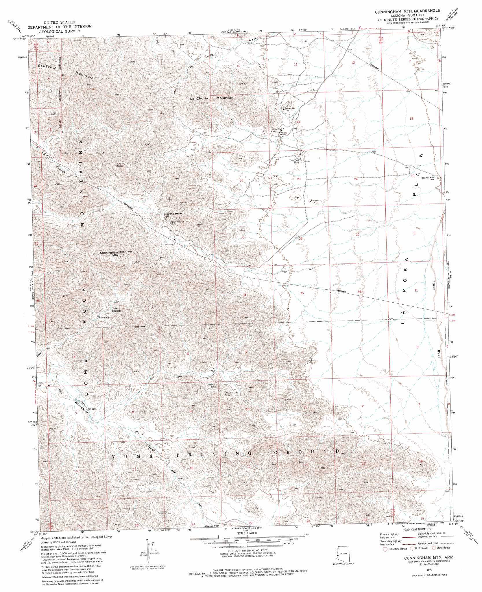
Cunningham Mountain Topo Map Arizona
To zoom in, hover over the map of Cunningham Mountain
USGS Topo Quad 33114e3 - 1:24,000 scale
| Topo Map Name: | Cunningham Mountain |
| USGS Topo Quad ID: | 33114e3 |
| Print Size: | ca. 21 1/4" wide x 27" high |
| Southeast Coordinates: | 33.5° N latitude / 114.25° W longitude |
| Map Center Coordinates: | 33.5625° N latitude / 114.3125° W longitude |
| U.S. State: | AZ |
| Filename: | o33114e3.jpg |
| Download Map JPG Image: | Cunningham Mountain topo map 1:24,000 scale |
| Map Type: | Topographic |
| Topo Series: | 7.5´ |
| Map Scale: | 1:24,000 |
| Source of Map Images: | United States Geological Survey (USGS) |
| Alternate Map Versions: |
Cunningham Mtn AZ 1971, updated 1974 Download PDF Buy paper map Cunningham Mtn AZ 1971, updated 1986 Download PDF Buy paper map Cunningham Mountain AZ 2011 Download PDF Buy paper map Cunningham Mountain AZ 2014 Download PDF Buy paper map |
1:24,000 Topo Quads surrounding Cunningham Mountain
Big Maria Mountains Se |
Moon Mountain |
Moon Mountain Se |
Bouse Sw |
Ibex Peak |
Blythe Ne |
La Paz Mountain |
Middle Camp Mountain |
Quartzsite |
Plomosa Pass |
Blythe |
Dome Rock Mountains Sw |
Cunningham Mountain |
South Of Quartzsite |
Crystal Hill |
Mule Wash |
North Trigo Peaks |
Trigo Pass |
Livingston Hills Nw |
Livingston Hills |
Cibola Se |
Mohave Peak |
Tweed Mine |
Stone Cabin |
Palm Canyon |
> Back to 33114e1 at 1:100,000 scale
> Back to 33114a1 at 1:250,000 scale
> Back to U.S. Topo Maps home
Cunningham Mountain topo map: Gazetteer
Cunningham Mountain: Gaps
Copper Bottom Pass elevation 511m 1676′Cunningham Mountain: Mines
Cinnabar Mine elevation 425m 1394′Copper Bottom Mine elevation 476m 1561′
Kellogg Mine elevation 365m 1197′
Yellow Dog Mine elevation 383m 1256′
Yum-Yum Mine elevation 361m 1184′
Cunningham Mountain: Springs
Tule Springs elevation 411m 1348′Cunningham Mountain: Summits
Cunningham Mountain elevation 1007m 3303′Ferra Peak elevation 896m 2939′
La Cholla Mountain elevation 695m 2280′
Sawtooth Mountain elevation 0m 0′
Cunningham Mountain: Wells
Beamer Well elevation 306m 1003′Kuehn Well elevation 304m 997′
Cunningham Mountain digital topo map on disk
Buy this Cunningham Mountain topo map showing relief, roads, GPS coordinates and other geographical features, as a high-resolution digital map file on DVD: