Livingston Hills Topo Map Arizona
To zoom in, hover over the map of Livingston Hills
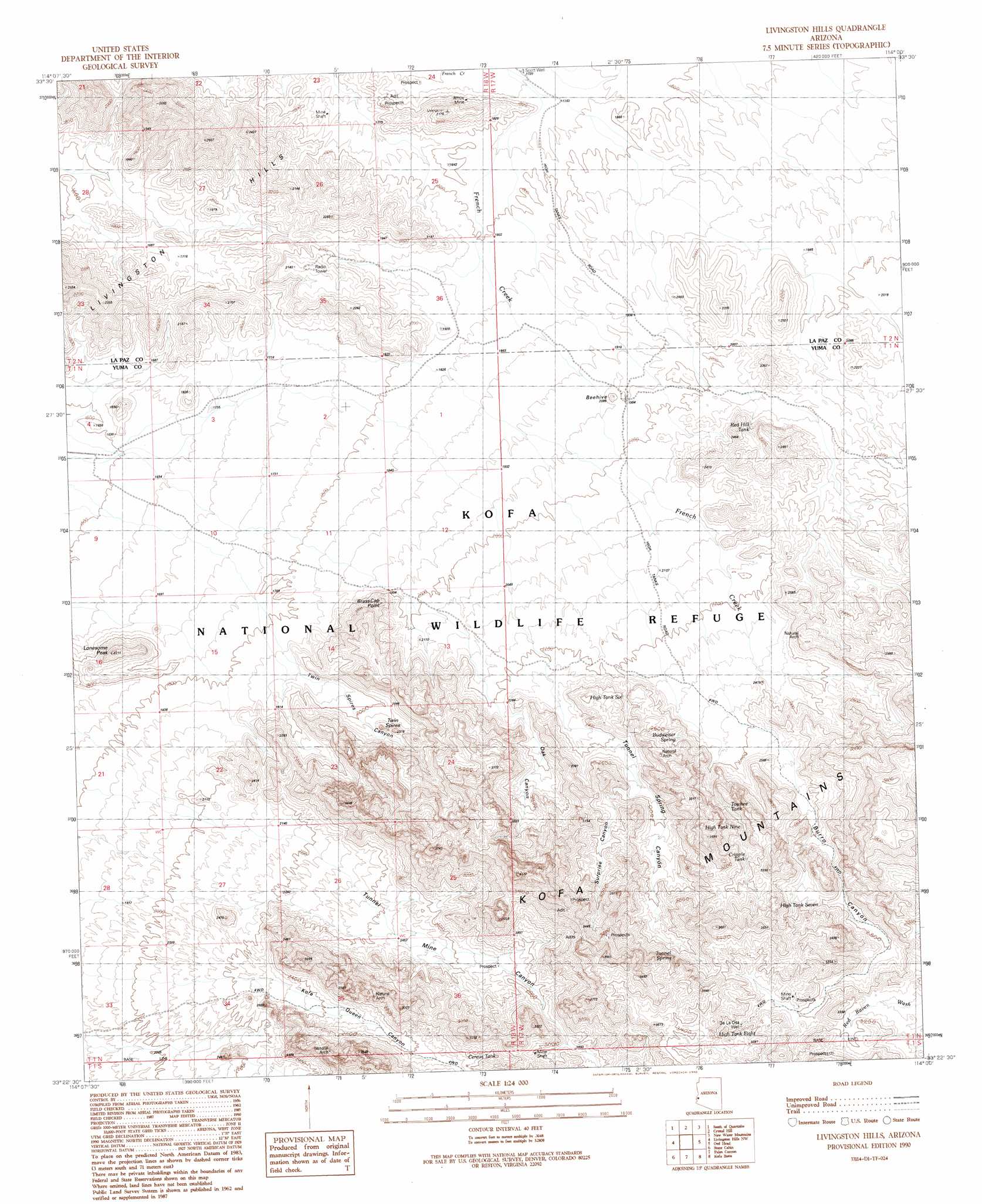
USGS Topo Quad 33114d1 - 1:24,000 scale
| Topo Map Name: | Livingston Hills |
| USGS Topo Quad ID: | 33114d1 |
| Print Size: | ca. 21 1/4" wide x 27" high |
| Southeast Coordinates: | 33.375° N latitude / 114° W longitude |
| Map Center Coordinates: | 33.4375° N latitude / 114.0625° W longitude |
| U.S. State: | AZ |
| Filename: | o33114d1.jpg |
| Download Map JPG Image: | Livingston Hills topo map 1:24,000 scale |
| Map Type: | Topographic |
| Topo Series: | 7.5´ |
| Map Scale: | 1:24,000 |
| Source of Map Images: | United States Geological Survey (USGS) |
| Alternate Map Versions: |
Livingston Hills AZ 1990, updated 1990 Download PDF Buy paper map Livingston Hills AZ 2011 Download PDF Buy paper map Livingston Hills AZ 2014 Download PDF Buy paper map |
1:24,000 Topo Quads surrounding Livingston Hills
Middle Camp Mountain |
Quartzsite |
Plomosa Pass |
Bear Hills |
Vicksburg |
Cunningham Mountain |
South Of Quartzsite |
Crystal Hill |
New Water Mountains |
New Water Well |
Trigo Pass |
Livingston Hills Nw |
Livingston Hills |
Owl Head |
Cholla Tank |
Tweed Mine |
Stone Cabin |
Palm Canyon |
Kofa Butte |
Hoodoo Well |
Red Hill Ne |
Arch Tank |
Kofa Deep Well |
Charlie Died Tank |
Engesser Pass |
> Back to 33114a1 at 1:100,000 scale
> Back to 33114a1 at 1:250,000 scale
> Back to U.S. Topo Maps home
Livingston Hills topo map: Gazetteer
Livingston Hills: Arches
Natural Arch elevation 913m 2995′Natural Arch elevation 932m 3057′
Natural Arch elevation 950m 3116′
Natural Arch elevation 840m 2755′
Livingston Hills: Capes
Brass Cap Point elevation 714m 2342′Livingston Hills: Lakes
Red Hill Tank elevation 666m 2185′Livingston Hills: Mines
Amuy Mine elevation 547m 1794′Tunnel Spring Mine elevation 821m 2693′
Livingston Hills: Pillars
Beehive elevation 633m 2076′Livingston Hills: Reservoirs
Beehive Tank elevation 587m 1925′Cereus Tank elevation 858m 2814′
Cripple Tank elevation 888m 2913′
High Tank elevation 879m 2883′
High Tank elevation 963m 3159′
High Tank Nine elevation 851m 2791′
High Tank Six elevation 708m 2322′
Towhee Tank elevation 848m 2782′
Livingston Hills: Springs
Budweiser Spring elevation 772m 2532′Tunnel Spring elevation 904m 2965′
Livingston Hills: Summits
Livingston Hills elevation 535m 1755′Lonesome Peak elevation 651m 2135′
Twin Spires elevation 688m 2257′
Livingston Hills: Valleys
Burro Canyon elevation 729m 2391′Four Palms Canyon elevation 663m 2175′
Kofa Queen Canyon elevation 681m 2234′
Oak Canyon elevation 658m 2158′
Surprise Canyon elevation 777m 2549′
Tunnel Mine Canyon elevation 647m 2122′
Tunnel Spring Canyon elevation 680m 2230′
Twin Spires Canyon elevation 569m 1866′
Livingston Hills: Wells
De La Ossa Well elevation 948m 3110′Scott Well elevation 0m 0′
Livingston Hills digital topo map on disk
Buy this Livingston Hills topo map showing relief, roads, GPS coordinates and other geographical features, as a high-resolution digital map file on DVD: