Bachelor Mountain Topo Map California
To zoom in, hover over the map of Bachelor Mountain
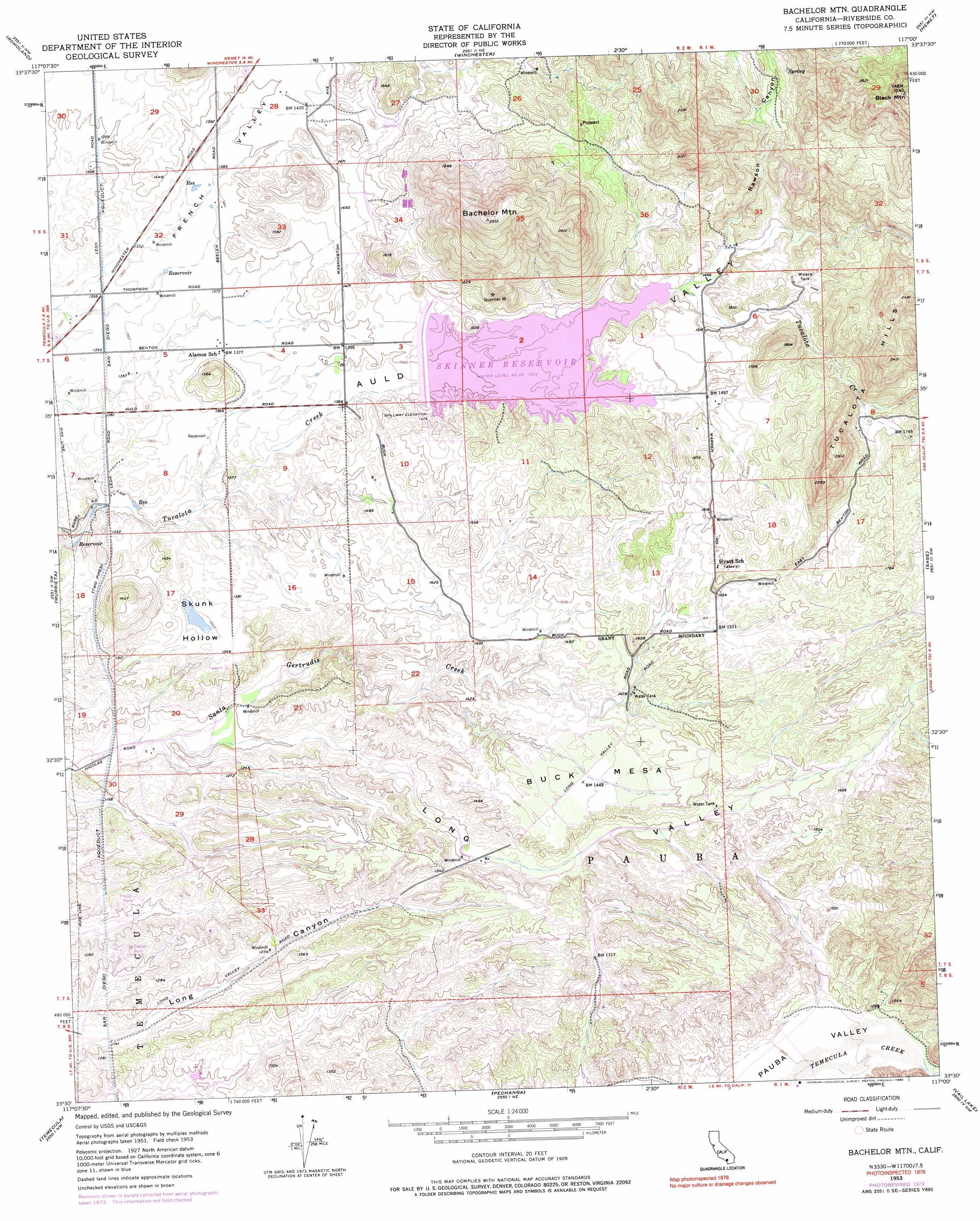
USGS Topo Quad 33117e1 - 1:24,000 scale
| Topo Map Name: | Bachelor Mountain |
| USGS Topo Quad ID: | 33117e1 |
| Print Size: | ca. 21 1/4" wide x 27" high |
| Southeast Coordinates: | 33.5° N latitude / 117° W longitude |
| Map Center Coordinates: | 33.5625° N latitude / 117.0625° W longitude |
| U.S. State: | CA |
| Filename: | o33117e1.jpg |
| Download Map JPG Image: | Bachelor Mountain topo map 1:24,000 scale |
| Map Type: | Topographic |
| Topo Series: | 7.5´ |
| Map Scale: | 1:24,000 |
| Source of Map Images: | United States Geological Survey (USGS) |
| Alternate Map Versions: |
Bachelor Mtn. CA 1953, updated 1955 Download PDF Buy paper map Bachelor Mtn. CA 1953, updated 1961 Download PDF Buy paper map Bachelor Mtn. CA 1953, updated 1971 Download PDF Buy paper map Bachelor Mtn. CA 1953, updated 1976 Download PDF Buy paper map Bachelor Mtn CA 1953, updated 1990 Download PDF Buy paper map Bachelor Mtn CA 1953, updated 1990 Download PDF Buy paper map Bachelor Mtn CA 1973, updated 1976 Download PDF Buy paper map Bachelor Mountain CA 2012 Download PDF Buy paper map Bachelor Mountain CA 2015 Download PDF Buy paper map |
1:24,000 Topo Quads surrounding Bachelor Mountain
Steele Peak |
Perris |
Lakeview |
San Jacinto |
Lake Fulmor |
Lake Elsinore |
Romoland |
Winchester |
Hemet |
Blackburn Canyon |
Wildomar |
Murrieta |
Bachelor Mountain |
Sage |
Cahuilla Mountain |
Fallbrook |
Temecula |
Pechanga |
Vail Lake |
Aguanga |
Morro Hill |
Bonsall |
Pala |
Boucher Hill |
Palomar Observatory |
> Back to 33117e1 at 1:100,000 scale
> Back to 33116a1 at 1:250,000 scale
> Back to U.S. Topo Maps home
Bachelor Mountain topo map: Gazetteer
Bachelor Mountain: Airports
Billy Joe Airport elevation 392m 1286′Bachelor Mountain: Basins
Skunk Hollow elevation 407m 1335′Bachelor Mountain: Dams
Robert A Skinner 35-012 Dam elevation 451m 1479′Bachelor Mountain: Parks
Lake Skinner County Park elevation 448m 1469′Veterans Park elevation 382m 1253′
Bachelor Mountain: Populated Places
Auld (historical) elevation 448m 1469′Country Road Estates elevation 426m 1397′
Dutch Village elevation 416m 1364′
Glenoaks Country elevation 517m 1696′
Heritage Mobile Home Park elevation 373m 1223′
High Acres Haciendas elevation 501m 1643′
Indian Oaks elevation 463m 1519′
South Park elevation 495m 1624′
Valle de los Caballos elevation 448m 1469′
Bachelor Mountain: Ranges
Tucalota Hills elevation 726m 2381′Bachelor Mountain: Reservoirs
Skinner Reservoir elevation 450m 1476′Bachelor Mountain: Summits
Bachelor Mountain elevation 753m 2470′Black Mountain elevation 930m 3051′
Buck Mesa elevation 473m 1551′
Bachelor Mountain: Valleys
Auld Valley elevation 402m 1318′Long Valley elevation 357m 1171′
Rawson Canyon elevation 449m 1473′
Bachelor Mountain digital topo map on disk
Buy this Bachelor Mountain topo map showing relief, roads, GPS coordinates and other geographical features, as a high-resolution digital map file on DVD: