Galivants Ferry Topo Map South Carolina
To zoom in, hover over the map of Galivants Ferry
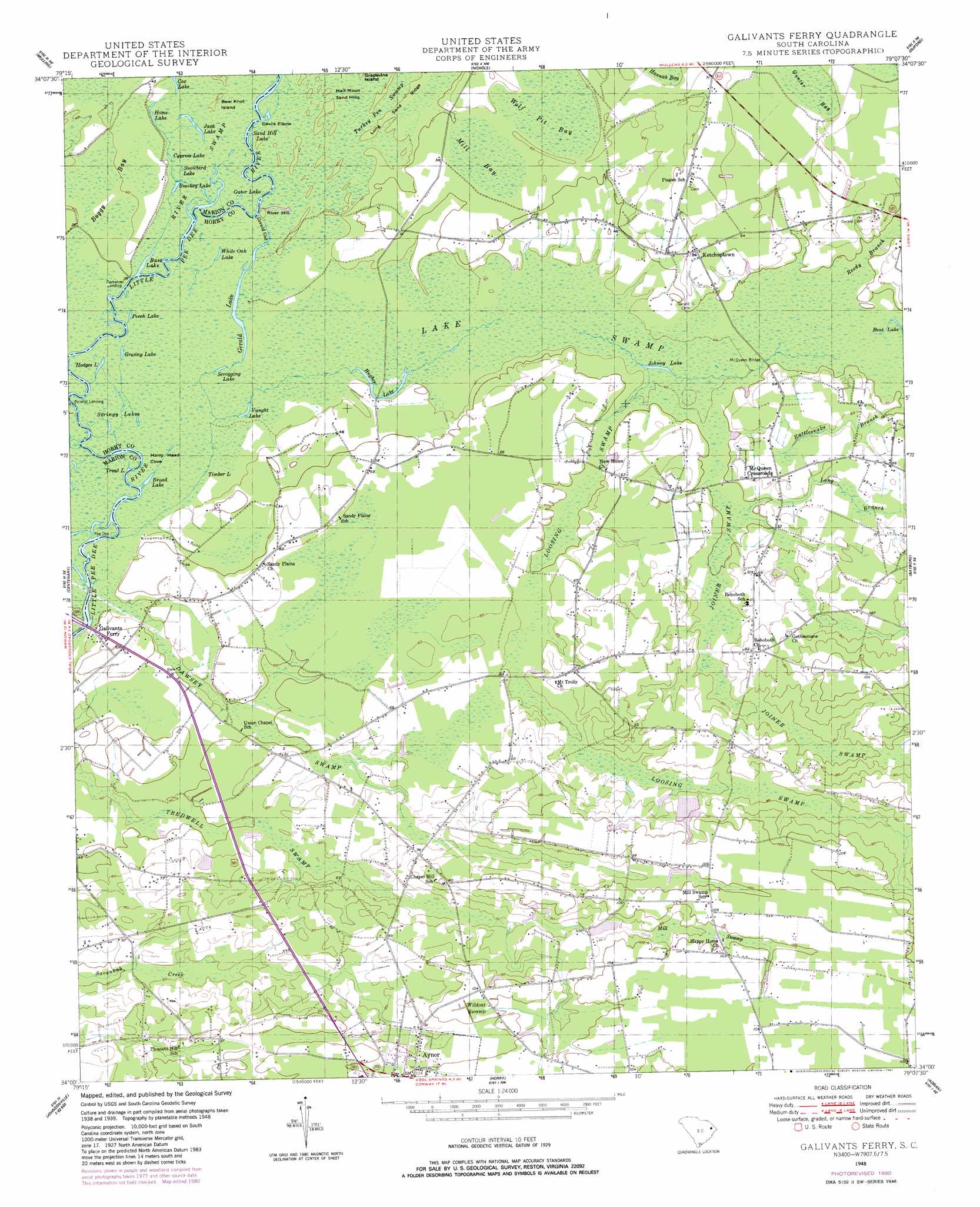
USGS Topo Quad 34079a2 - 1:24,000 scale
| Topo Map Name: | Galivants Ferry |
| USGS Topo Quad ID: | 34079a2 |
| Print Size: | ca. 21 1/4" wide x 27" high |
| Southeast Coordinates: | 34° N latitude / 79.125° W longitude |
| Map Center Coordinates: | 34.0625° N latitude / 79.1875° W longitude |
| U.S. State: | SC |
| Filename: | o34079a2.jpg |
| Download Map JPG Image: | Galivants Ferry topo map 1:24,000 scale |
| Map Type: | Topographic |
| Topo Series: | 7.5´ |
| Map Scale: | 1:24,000 |
| Source of Map Images: | United States Geological Survey (USGS) |
| Alternate Map Versions: |
Galivants Ferry SC 1948, updated 1981 Download PDF Buy paper map Galivants Ferry SC 1950 Download PDF Buy paper map Galivants Ferry SC 1950 Download PDF Buy paper map Galivants Ferry SC 2011 Download PDF Buy paper map Galivants Ferry SC 2014 Download PDF Buy paper map |
1:24,000 Topo Quads surrounding Galivants Ferry
Latta |
Fork |
Lake View |
Fair Bluff |
Cerro Gordo |
Marion |
Mullins |
Nichols |
Duford |
Tabor City West |
Friendship |
Centenary |
Galivants Ferry |
Bayboro |
Loris |
Gresham |
Britton Neck |
Horry |
Adrian |
Shell |
Johnsonville |
Snow Island |
Dongola |
Conway |
Nixonville |
> Back to 34079a1 at 1:100,000 scale
> Back to 34078a1 at 1:250,000 scale
> Back to U.S. Topo Maps home
Galivants Ferry topo map: Gazetteer
Galivants Ferry: Bends
Devils Elbow elevation 11m 36′Galivants Ferry: Bridges
Galivants Ferry Bridge elevation 12m 39′McQueen Bridge elevation 13m 42′
Galivants Ferry: Dams
Graham Mill Pond Dam D-3616 elevation 25m 82′Howles Trailer Park Pond Dam D-3618 elevation 29m 95′
South Carolina Noname 26003 D-3617 Dam elevation 22m 72′
Galivants Ferry: Guts
Gerald Gut elevation 12m 39′Galivants Ferry: Islands
Bear Knot Island elevation 12m 39′Pee Dee Island elevation 12m 39′
Galivants Ferry: Lakes
Bass Lake elevation 11m 36′Broad Lake elevation 11m 36′
Cypress Lake elevation 12m 39′
Gator Lake elevation 11m 36′
Gerald Lake elevation 10m 32′
Granny Lake elevation 11m 36′
Hodges Lake elevation 11m 36′
Home Lake elevation 12m 39′
Hughes Lake elevation 11m 36′
Jack Lake elevation 11m 36′
Johnny Lake elevation 11m 36′
Perch Lake elevation 11m 36′
Sand Hill Lake elevation 11m 36′
Scrogging Lake elevation 11m 36′
Smokey Lake elevation 12m 39′
Snowbird Lake elevation 12m 39′
Stringy Lakes elevation 11m 36′
Timber Lake elevation 12m 39′
Trout Lake elevation 11m 36′
Vaught Lake elevation 12m 39′
White Oak Lake elevation 11m 36′
Galivants Ferry: Populated Places
Cartwheel Landing elevation 11m 36′Galivants Ferry elevation 13m 42′
Ketchuptown elevation 19m 62′
McQueen Crossroads elevation 19m 62′
Polecat Landing elevation 11m 36′
Galivants Ferry: Reservoirs
Graham Mill Pond elevation 25m 82′Howles Big Pond elevation 22m 72′
Galivants Ferry: Streams
Long Branch elevation 14m 45′Rattlesnake Branch elevation 15m 49′
Reedy Branch elevation 14m 45′
Galivants Ferry: Summits
Half Moon Sand Hills elevation 12m 39′River Hill elevation 12m 39′
Galivants Ferry: Swamps
Boggy Bay elevation 12m 39′Dawsey Swamp elevation 15m 49′
Harry Head Cove elevation 12m 39′
Joiner Swamp elevation 18m 59′
Loosing Swamp elevation 17m 55′
Mill Bay elevation 17m 55′
Mill Swamp elevation 26m 85′
Tredwell Swamp elevation 15m 49′
Turkey Pen Swamp elevation 12m 39′
Wildcat Swamp elevation 31m 101′
Wolf Pit Bay elevation 17m 55′
Galivants Ferry digital topo map on disk
Buy this Galivants Ferry topo map showing relief, roads, GPS coordinates and other geographical features, as a high-resolution digital map file on DVD:
South Carolina, Western North Carolina & Northeastern Georgia
Buy digital topo maps: South Carolina, Western North Carolina & Northeastern Georgia