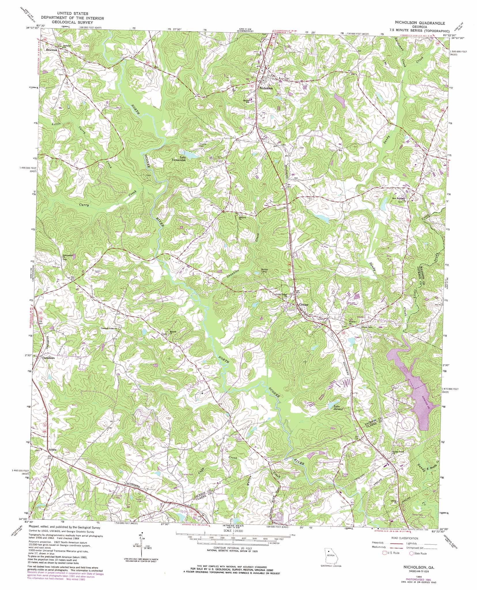
Nicholson Topo Map Georgia
To zoom in, hover over the map of Nicholson
USGS Topo Quad 34083a4 - 1:24,000 scale
| Topo Map Name: | Nicholson |
| USGS Topo Quad ID: | 34083a4 |
| Print Size: | ca. 21 1/4" wide x 27" high |
| Southeast Coordinates: | 34° N latitude / 83.375° W longitude |
| Map Center Coordinates: | 34.0625° N latitude / 83.4375° W longitude |
| U.S. State: | GA |
| Filename: | o34083a4.jpg |
| Download Map JPG Image: | Nicholson topo map 1:24,000 scale |
| Map Type: | Topographic |
| Topo Series: | 7.5´ |
| Map Scale: | 1:24,000 |
| Source of Map Images: | United States Geological Survey (USGS) |
| Alternate Map Versions: |
Nicholson GA 1964, updated 1965 Download PDF Buy paper map Nicholson GA 1964, updated 1986 Download PDF Buy paper map Nicholson GA 2011 Download PDF Buy paper map Nicholson GA 2014 Download PDF Buy paper map |
1:24,000 Topo Quads surrounding Nicholson
Gillsville |
Maysville |
Homer |
Ashland |
Carnesville |
Pendergrass |
Apple Valley |
Commerce |
Ila |
Danielsville North |
Winder North |
Jefferson |
Nicholson |
Hull |
Danielsville South |
Winder South |
Statham |
Athens West |
Athens East |
Crawford |
Monroe |
High Shoals |
Watkinsville |
Barnett Shoals |
Maxeys |
> Back to 34083a1 at 1:100,000 scale
> Back to 34082a1 at 1:250,000 scale
> Back to U.S. Topo Maps home
Nicholson topo map: Gazetteer
Nicholson: Bridges
Newton Bridge elevation 188m 616′Nicholson: Dams
Bishop Dam elevation 218m 715′Bishops Lake Dam elevation 221m 725′
Jarrett Lake Dam elevation 235m 770′
Lake Jarekit Dam elevation 207m 679′
Lake Yamacutah Dam elevation 215m 705′
Sandy Creek Structure Eight Dam elevation 219m 718′
Nicholson: Parks
Sandy Creek Park elevation 209m 685′Nicholson: Populated Places
Attica elevation 255m 836′Brockton elevation 247m 810′
Center elevation 253m 830′
Clarksboro elevation 260m 853′
Hamilton Trailer Park elevation 256m 839′
Nicholson elevation 256m 839′
Northridge elevation 236m 774′
Nicholson: Reservoirs
Bishop Lake elevation 218m 715′Bishops Lake elevation 221m 725′
Dam Number 10 elevation 195m 639′
Jarrett Lake elevation 235m 770′
Lake Jarekit elevation 207m 679′
Lake Uamacutah elevation 208m 682′
Lake Yamacutah elevation 215m 705′
Reservoir Eight elevation 219m 718′
Nicholson: Streams
Cabin Creek elevation 201m 659′Crooked Creek elevation 195m 639′
Cubb Creek elevation 201m 659′
Curry Creek elevation 195m 639′
East Sandy Creek elevation 189m 620′
Hardeman Creek elevation 219m 718′
Little Curry Creek elevation 201m 659′
Little Sandy Creek elevation 201m 659′
Shankles Creek elevation 195m 639′
Walton Creek elevation 189m 620′
Nicholson digital topo map on disk
Buy this Nicholson topo map showing relief, roads, GPS coordinates and other geographical features, as a high-resolution digital map file on DVD:
South Carolina, Western North Carolina & Northeastern Georgia
Buy digital topo maps: South Carolina, Western North Carolina & Northeastern Georgia