Baldwin Park Topo Map California
To zoom in, hover over the map of Baldwin Park
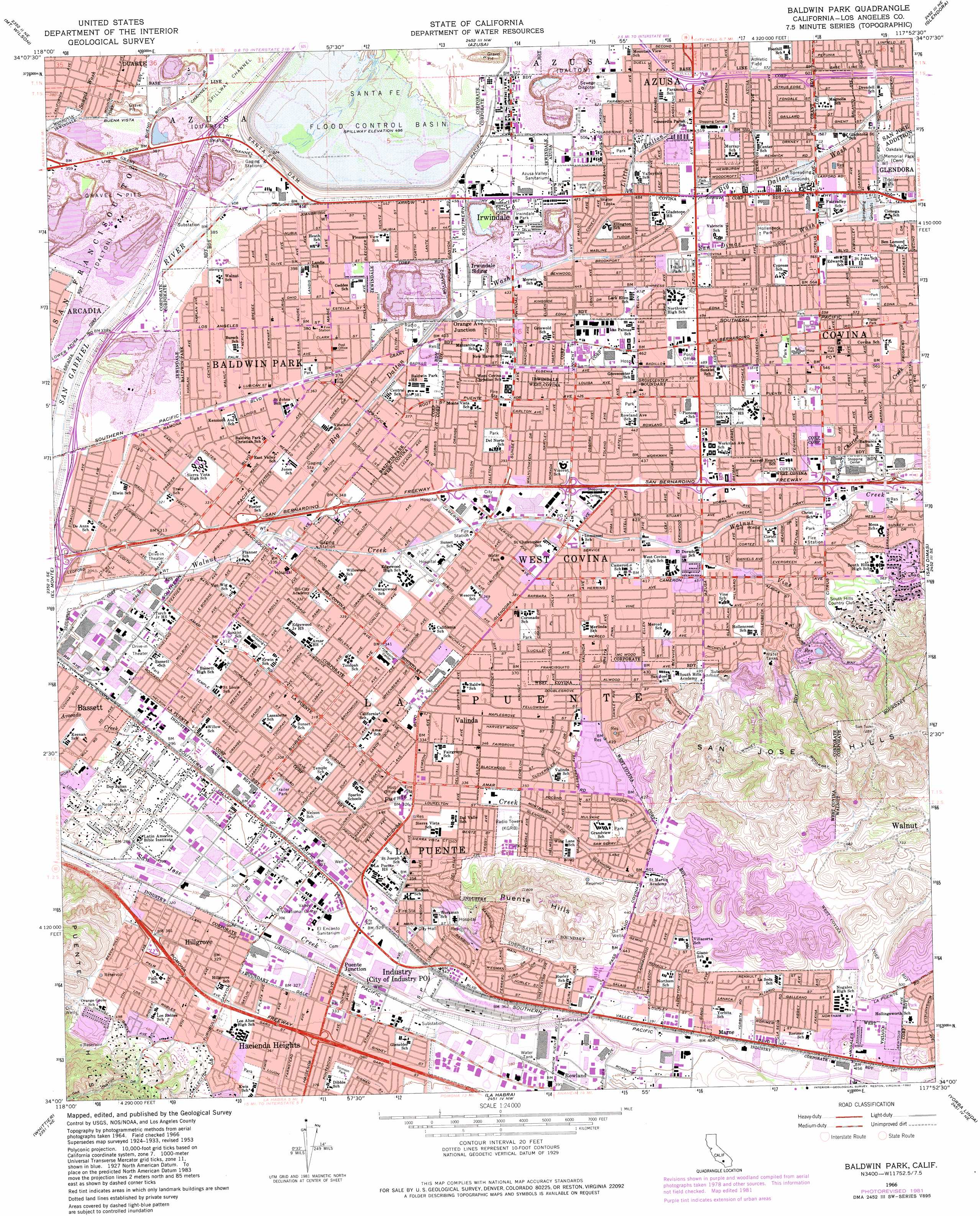
USGS Topo Quad 34117a8 - 1:24,000 scale
| Topo Map Name: | Baldwin Park |
| USGS Topo Quad ID: | 34117a8 |
| Print Size: | ca. 21 1/4" wide x 27" high |
| Southeast Coordinates: | 34° N latitude / 117.875° W longitude |
| Map Center Coordinates: | 34.0625° N latitude / 117.9375° W longitude |
| U.S. State: | CA |
| Filename: | o34117a8.jpg |
| Download Map JPG Image: | Baldwin Park topo map 1:24,000 scale |
| Map Type: | Topographic |
| Topo Series: | 7.5´ |
| Map Scale: | 1:24,000 |
| Source of Map Images: | United States Geological Survey (USGS) |
| Alternate Map Versions: |
Baldwin Park CA 1953, updated 1955 Download PDF Buy paper map Baldwin Park CA 1953, updated 1960 Download PDF Buy paper map Baldwin Park CA 1966, updated 1967 Download PDF Buy paper map Baldwin Park CA 1966, updated 1967 Download PDF Buy paper map Baldwin Park CA 1966, updated 1975 Download PDF Buy paper map Baldwin Park CA 1966, updated 1982 Download PDF Buy paper map Baldwin Park CA 1966, updated 1982 Download PDF Buy paper map Baldwin Park CA 2012 Download PDF Buy paper map Baldwin Park CA 2015 Download PDF Buy paper map |
1:24,000 Topo Quads surrounding Baldwin Park
Condor Peak |
Chilao Flat |
Waterman Mountain |
Crystal Lake |
Mount San Antonio |
Pasadena |
Mount Wilson |
Azusa |
Glendora |
Mount Baldy |
Los Angeles |
El Monte |
Baldwin Park |
San Dimas |
Ontario |
South Gate |
Whittier |
La Habra |
Yorba Linda |
Prado Dam |
Long Beach |
Los Alamitos |
Anaheim |
Orange |
Black Star Canyon |
> Back to 34117a1 at 1:100,000 scale
> Back to 34116a1 at 1:250,000 scale
> Back to U.S. Topo Maps home
Baldwin Park topo map: Gazetteer
Baldwin Park: Airports
City of Industry Civic Financial Center Heliport elevation 97m 318′Haddicks Heliport elevation 95m 311′
Los Angeles County Sheriffs Department Heliport elevation 115m 377′
Puente Sky Ranch (historical) elevation 118m 387′
Recreation and Conference Center Heliport elevation 171m 561′
Baldwin Park: Canals
Hacienda Channel elevation 117m 383′Baldwin Park: Crossings
Exit 14A elevation 116m 380′Exit 14B elevation 117m 383′
Exit 16 elevation 110m 360′
Exit 22 elevation 92m 301′
Exit 23 elevation 97m 318′
Exit 24 elevation 96m 314′
Exit 25 elevation 109m 357′
Exit 26 elevation 123m 403′
Exit 31B elevation 92m 301′
Exit 31C elevation 97m 318′
Exit 32A elevation 100m 328′
Exit 32B elevation 104m 341′
Exit 33 elevation 106m 347′
Exit 34A elevation 115m 377′
Exit 34B elevation 119m 390′
Exit 35 elevation 123m 403′
Exit 36 elevation 138m 452′
Exit 37A elevation 147m 482′
Exit 37B elevation 151m 495′
Exit 40 elevation 164m 538′
Exit 41 elevation 183m 600′
Baldwin Park: Dams
Santa Fe Dam elevation 139m 456′Baldwin Park: Parks
Allen J Martin Park elevation 97m 318′Avocado Heights Park elevation 92m 301′
Barnes Park elevation 92m 301′
Barranca Park elevation 163m 534′
Bassett Park elevation 92m 301′
Cameron Park elevation 128m 419′
Central Park West elevation 116m 380′
City Park elevation 170m 557′
Cortez Park elevation 147m 482′
Covina Park elevation 163m 534′
Cypress Park elevation 168m 551′
Del Norte Park elevation 121m 396′
Edna Park elevation 168m 551′
Friendship Park elevation 154m 505′
Galster Wilderness Park elevation 212m 695′
Gingrich Park elevation 139m 456′
Gladstone Park elevation 166m 544′
Hollenbeck Park elevation 166m 544′
Industry Hills Recreation Center elevation 153m 501′
Irwindale Park elevation 142m 465′
Kelby Park elevation 180m 590′
La Puente Park elevation 103m 337′
Los Robles County Park elevation 133m 436′
Manzanita Park elevation 116m 380′
Morgan Park elevation 114m 374′
Orangewood Park elevation 111m 364′
Palm View Park elevation 136m 446′
Rimgrove Drive Park elevation 123m 403′
Shadow Oak Park elevation 190m 623′
Stimson Park elevation 112m 367′
Sunshine Park elevation 128m 419′
Valleydale Park elevation 152m 498′
Walmerado Park elevation 116m 380′
Walnut Creek Nature Park elevation 93m 305′
Walnut Hills Park elevation 184m 603′
Woodgrove Park elevation 141m 462′
Baldwin Park: Populated Places
Avocado Heights elevation 103m 337′Baldwin Park elevation 114m 374′
Bassett elevation 90m 295′
Citrus elevation 178m 583′
Covina elevation 170m 557′
Hillgrove elevation 101m 331′
Industry elevation 98m 321′
Irwindale elevation 143m 469′
La Puente elevation 107m 351′
Marne elevation 123m 403′
Orange Avenue Junction elevation 124m 406′
Puente Junction elevation 100m 328′
Rowland elevation 120m 393′
South San Jose Hills elevation 127m 416′
Valinda elevation 106m 347′
West Covina elevation 117m 383′
West Puente Valley elevation 98m 321′
Woodside Village elevation 212m 695′
Baldwin Park: Post Offices
Baldwin Park Post Office elevation 118m 387′Bassett Branch La Puente Post Office elevation 89m 291′
City of Industry Post Office elevation 99m 324′
Covina Post Office elevation 169m 554′
Irwindale Post Office elevation 142m 465′
La Puente Post Office elevation 99m 324′
South Hill Station West Covina Post Office elevation 157m 515′
West Covina Post Office elevation 120m 393′
Baldwin Park: Reservoirs
Santa Fe Flood Control Basin elevation 143m 469′Baldwin Park: Streams
Big Dalton Wash elevation 98m 321′Charter Oak Creek elevation 141m 462′
Little Dalton Wash elevation 135m 442′
Puente Creek elevation 89m 291′
San Dimas Wash elevation 141m 462′
Vine Creek elevation 138m 452′
Baldwin Park digital topo map on disk
Buy this Baldwin Park topo map showing relief, roads, GPS coordinates and other geographical features, as a high-resolution digital map file on DVD: