Williams Topo Map North Carolina
To zoom in, hover over the map of Williams
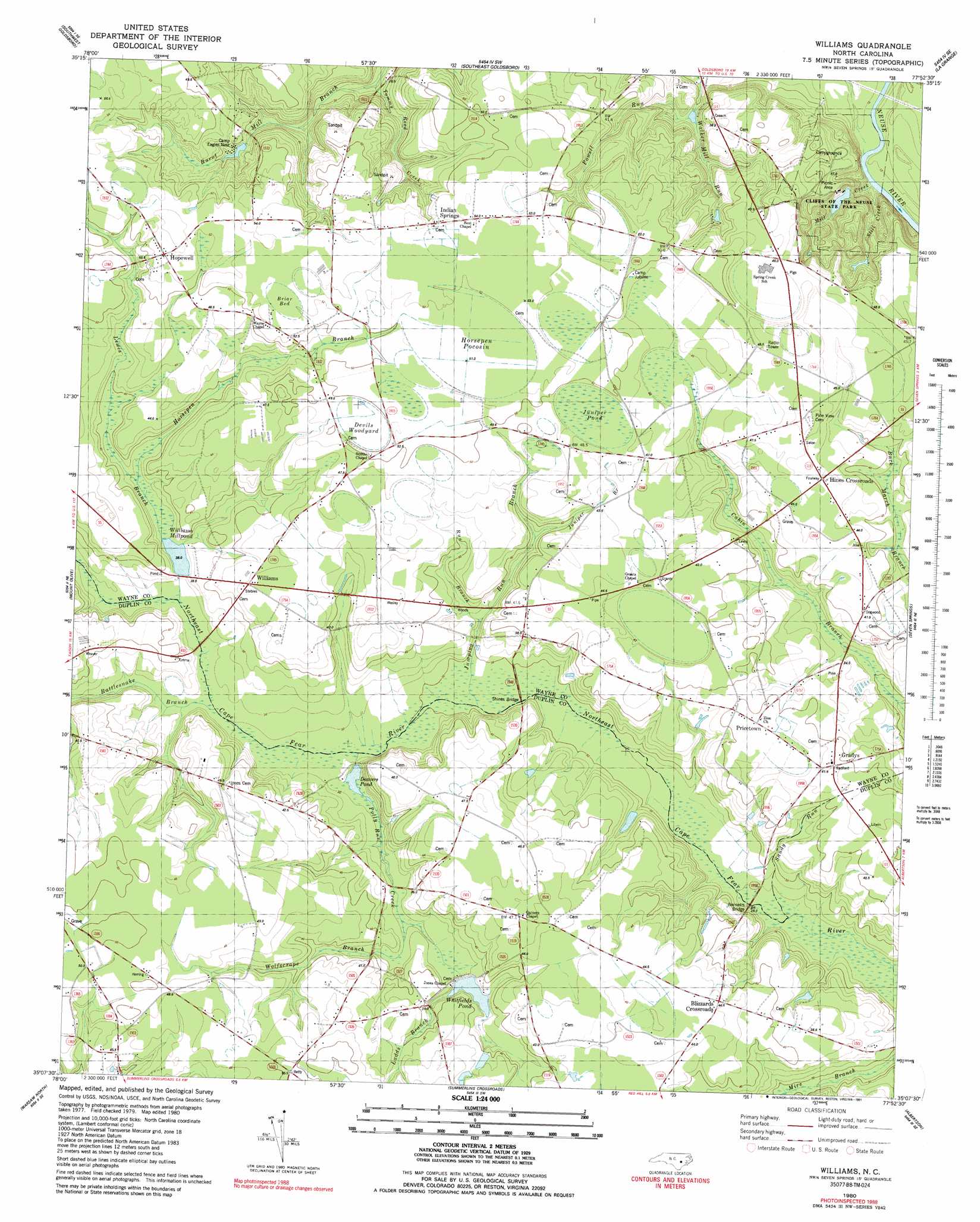
USGS Topo Quad 35077b8 - 1:24,000 scale
| Topo Map Name: | Williams |
| USGS Topo Quad ID: | 35077b8 |
| Print Size: | ca. 21 1/4" wide x 27" high |
| Southeast Coordinates: | 35.125° N latitude / 77.875° W longitude |
| Map Center Coordinates: | 35.1875° N latitude / 77.9375° W longitude |
| U.S. State: | NC |
| Filename: | o35077b8.jpg |
| Download Map JPG Image: | Williams topo map 1:24,000 scale |
| Map Type: | Topographic |
| Topo Series: | 7.5´ |
| Map Scale: | 1:24,000 |
| Source of Map Images: | United States Geological Survey (USGS) |
| Alternate Map Versions: |
Williams NC 1980, updated 1981 Download PDF Buy paper map Williams NC 1980, updated 1991 Download PDF Buy paper map Williams NC 2010 Download PDF Buy paper map Williams NC 2013 Download PDF Buy paper map Williams NC 2016 Download PDF Buy paper map |
1:24,000 Topo Quads surrounding Williams
Princeton |
Northwest Goldsboro |
Northeast Goldsboro |
Jason |
Snow Hill |
Grantham |
Southwest Goldsboro |
Southeast Goldsboro |
La Grange |
Falling Creek |
Dobbersville |
Mount Olive |
Williams |
Seven Springs |
Deep Run |
Faison |
Warsaw North |
Summerlins Crossroads |
Albertson |
Pink Hill |
Turkey |
Warsaw South |
Kenansville |
Beulaville |
Potters Hill |
> Back to 35077a1 at 1:100,000 scale
> Back to 35076a1 at 1:250,000 scale
> Back to U.S. Topo Maps home
Williams topo map: Gazetteer
Williams: Bridges
Bennetts Bridge elevation 26m 85′Shines Bridge elevation 29m 95′
Williams: Dams
Holly Lake Dam elevation 35m 114′Lake Genele Dam elevation 30m 98′
Williams Millpond Dam elevation 35m 114′
Williams: Parks
Cliffs of the Neuse State Park elevation 28m 91′Williams: Populated Places
Blizzards Crossroads elevation 46m 150′Gradys elevation 41m 134′
Hines Crossroads elevation 45m 147′
Hopewell elevation 53m 173′
Indian Springs elevation 52m 170′
Pricetown elevation 41m 134′
Williams elevation 44m 144′
Williams: Reservoirs
Deavers Pond elevation 32m 104′Holly Lake elevation 35m 114′
Lake Genele elevation 30m 98′
Whitfields Pond elevation 35m 114′
Williams Millpond elevation 35m 114′
Williams: Streams
Green Branch elevation 41m 134′Horsepen Branch elevation 36m 118′
Jumping Juniper Branch elevation 45m 147′
Jumping Run Branch elevation 29m 95′
Ladds Branch elevation 37m 121′
Lewis Branch elevation 33m 108′
Polly Run Creek elevation 32m 104′
Powell Run elevation 24m 78′
Rattlesnake Branch elevation 31m 101′
Run Branch elevation 32m 104′
Tommy Reed Creek elevation 24m 78′
Wolfscrape Branch elevation 35m 114′
Williams: Swamps
Briar Bed elevation 51m 167′Devils Woodyard elevation 49m 160′
Horsepen Pocosin elevation 51m 167′
Juniper Pond elevation 48m 157′
Williams digital topo map on disk
Buy this Williams topo map showing relief, roads, GPS coordinates and other geographical features, as a high-resolution digital map file on DVD:
Atlantic Coast (NY, NJ, PA, DE, MD, VA, NC)
Buy digital topo maps: Atlantic Coast (NY, NJ, PA, DE, MD, VA, NC)
 map DVD")