Tuskeegee Topo Map North Carolina
To zoom in, hover over the map of Tuskeegee
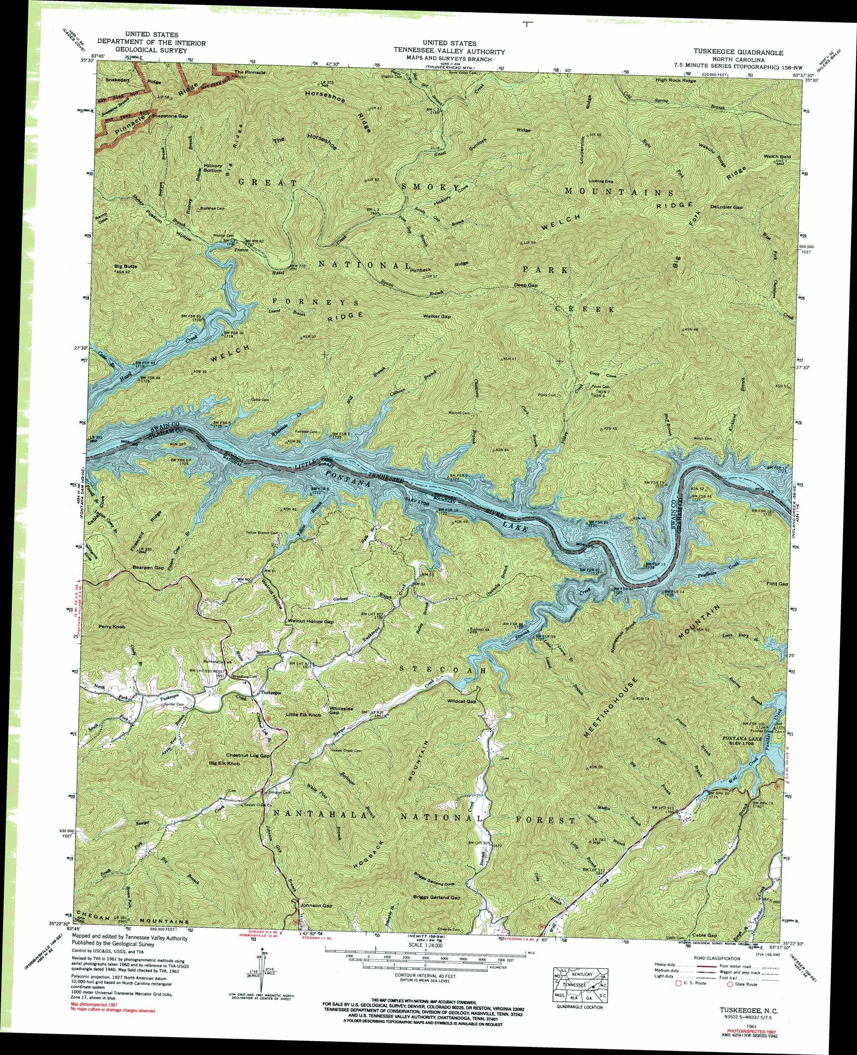
USGS Topo Quad 35083d6 - 1:24,000 scale
| Topo Map Name: | Tuskeegee |
| USGS Topo Quad ID: | 35083d6 |
| Print Size: | ca. 21 1/4" wide x 27" high |
| Southeast Coordinates: | 35.375° N latitude / 83.625° W longitude |
| Map Center Coordinates: | 35.4375° N latitude / 83.6875° W longitude |
| U.S. State: | NC |
| Filename: | o35083d6.jpg |
| Download Map JPG Image: | Tuskeegee topo map 1:24,000 scale |
| Map Type: | Topographic |
| Topo Series: | 7.5´ |
| Map Scale: | 1:24,000 |
| Source of Map Images: | United States Geological Survey (USGS) |
| Alternate Map Versions: |
Proctor NC 1936 Download PDF Buy paper map Proctor NC 1940, updated 1958 Download PDF Buy paper map Proctor NC 1941 Download PDF Buy paper map Tuskeegee NC 1961, updated 1964 Download PDF Buy paper map Tuskeegee NC 1961, updated 1972 Download PDF Buy paper map Tuskeegee NC 1961, updated 1984 Download PDF Buy paper map Tuskeegee NC 1961, updated 1990 Download PDF Buy paper map Tuskeegee NC 1976, updated 1978 Download PDF Buy paper map Tuskeegee NC 2011 Download PDF Buy paper map Tuskeegee NC 2013 Download PDF Buy paper map Tuskeegee NC 2016 Download PDF Buy paper map |
| FStopo: | US Forest Service topo Tuskeegee is available: Download FStopo PDF Download FStopo TIF |
1:24,000 Topo Quads surrounding Tuskeegee
Blockhouse |
Kinzel Springs |
Wear Cove |
Gatlinburg |
Mount Le Conte |
Calderwood |
Cades Cove |
Thunderhead Mountain |
Silers Bald |
Clingmans Dome |
Tapoco |
Fontana Dam |
Tuskeegee |
Noland Creek |
Bryson City |
Santeetlah Creek |
Robbinsville |
Hewitt |
Wesser |
Alarka |
Marble |
Andrews |
Topton |
Wayah Bald |
Franklin |
> Back to 35083a1 at 1:100,000 scale
> Back to 35082a1 at 1:250,000 scale
> Back to U.S. Topo Maps home
Tuskeegee topo map: Gazetteer
Tuskeegee: Basins
The Horseshoe elevation 702m 2303′Williams Cove elevation 578m 1896′
Tuskeegee: Flats
Hickory Bottom elevation 639m 2096′Tuskeegee: Gaps
Bearpen Gap elevation 736m 2414′Briggs Garland Gap elevation 804m 2637′
Cable Gap elevation 647m 2122′
Chestnut Log Gap elevation 656m 2152′
Deep Gap elevation 988m 3241′
DeLozier Gap elevation 1389m 4557′
Johnson Gap elevation 769m 2522′
Licklog Gap elevation 1258m 4127′
Soapstone Gap elevation 914m 2998′
Walker Gap elevation 871m 2857′
Walnut Hollow Gap elevation 621m 2037′
Whiteside Gap elevation 618m 2027′
Wildcat Gap elevation 612m 2007′
Tuskeegee: Populated Places
Proctor elevation 522m 1712′Tuskeegee elevation 577m 1893′
Tuskeegee: Ridges
Big Fork Ridge elevation 1464m 4803′Big Ridge elevation 837m 2746′
Firescald Ridge elevation 808m 2650′
Gunlock Ridge elevation 967m 3172′
Horseshoe Ridge elevation 995m 3264′
Loudermilk Ridge elevation 1098m 3602′
Pinnacle Ridge elevation 898m 2946′
Pullback Ridge elevation 912m 2992′
Snakeden Ridge elevation 844m 2769′
Wasulu Ridge elevation 1340m 4396′
Welch Ridge elevation 1296m 4251′
Tuskeegee: Streams
Apple Tree Branch elevation 581m 1906′Bailey Branch elevation 534m 1751′
Bearpen Branch elevation 556m 1824′
Big Branch elevation 690m 2263′
Big Branch elevation 527m 1729′
Bluff Branch elevation 507m 1663′
Boelinger Branch elevation 565m 1853′
Bone Valley Creek elevation 692m 2270′
Brown Fork elevation 747m 2450′
Cable Branch elevation 511m 1676′
Calhoun Branch elevation 507m 1663′
Chambers Creek elevation 507m 1663′
Chesquaw Branch elevation 507m 1663′
Chestnut Log Branch elevation 573m 1879′
Cindy Branch elevation 596m 1955′
Clark Branch elevation 510m 1673′
Cody Branch elevation 572m 1876′
Garland Branch elevation 539m 1768′
Haw Gap Branch elevation 673m 2208′
Hickory Bottom Branch elevation 537m 1761′
Hyde Branch elevation 507m 1663′
Indian Camp Branch elevation 542m 1778′
Johnson Gap Branch elevation 598m 1961′
Kirkland Branch elevation 507m 1663′
Laurel Branch elevation 517m 1696′
Laurel Branch elevation 556m 1824′
Laurel Branch elevation 519m 1702′
Little Branch elevation 563m 1847′
Little Laurel Branch elevation 516m 1692′
Lovin Entry Branch elevation 522m 1712′
Maple Branch elevation 557m 1827′
Medlin Branch elevation 549m 1801′
Meetinghouse Branch elevation 507m 1663′
Mill Branch elevation 507m 1663′
North Fork Tuskeegee Creek elevation 596m 1955′
Owensby Branch elevation 509m 1669′
Pendleton Creek elevation 507m 1663′
Pilkey Creek elevation 508m 1666′
Pine Gap Branch elevation 612m 2007′
Poison Cove Branch elevation 507m 1663′
Powell Branch elevation 507m 1663′
Proctor Branch elevation 519m 1702′
Right Fork Cold Spring Branch elevation 840m 2755′
Roaring Branch elevation 517m 1696′
Rough Branch elevation 561m 1840′
Rowan Branch elevation 595m 1952′
Sandy Gap Branch elevation 615m 2017′
Sawyer Creek elevation 524m 1719′
Shehan Branch elevation 520m 1706′
South Fork Sawyer Creek elevation 663m 2175′
South Fork Tuskeegee Creek elevation 607m 1991′
Stecoah Creek elevation 509m 1669′
Sugar Fork elevation 702m 2303′
Taylor Branch elevation 525m 1722′
Tobacco Branch elevation 510m 1673′
Tuskeegee Creek elevation 508m 1666′
White Pine Branch elevation 588m 1929′
Whiteside Creek elevation 507m 1663′
Wolf Creek elevation 509m 1669′
Yellow Branch elevation 507m 1663′
Tuskeegee: Summits
Big Butte elevation 963m 3159′Big Elk Knob elevation 766m 2513′
Hogback Mountain elevation 1052m 3451′
Little Elk Knob elevation 719m 2358′
Meetinghouse Mountain elevation 893m 2929′
Perry Knob elevation 975m 3198′
The Pinnacle elevation 1108m 3635′
Welch Bald elevation 1474m 4835′
Tuskeegee: Valleys
Briggs Garland Cove elevation 576m 1889′Cable Cove elevation 507m 1663′
Coot Cove elevation 547m 1794′
Hickory Cove elevation 626m 2053′
Possum Hollow elevation 525m 1722′
Ramp Cove elevation 615m 2017′
Walnut Hollow elevation 532m 1745′
Tuskeegee digital topo map on disk
Buy this Tuskeegee topo map showing relief, roads, GPS coordinates and other geographical features, as a high-resolution digital map file on DVD:
South Carolina, Western North Carolina & Northeastern Georgia
Buy digital topo maps: South Carolina, Western North Carolina & Northeastern Georgia