Noland Creek Topo Map North Carolina
To zoom in, hover over the map of Noland Creek
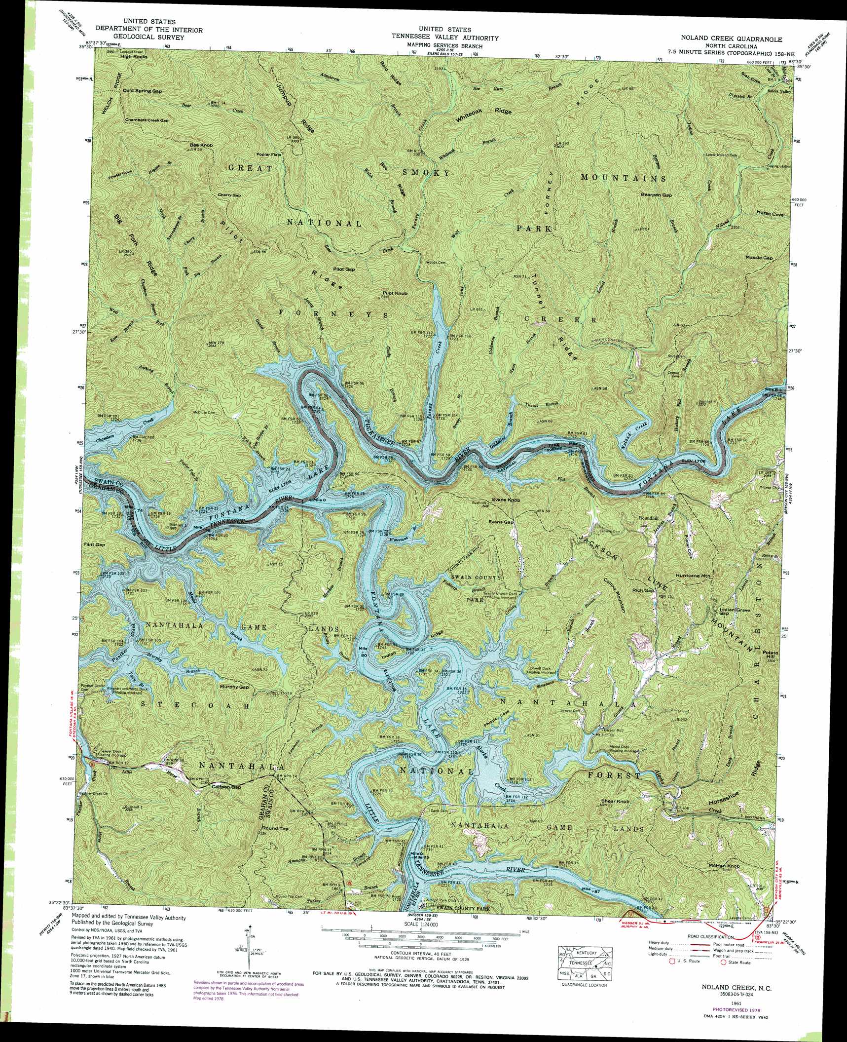
USGS Topo Quad 35083d5 - 1:24,000 scale
| Topo Map Name: | Noland Creek |
| USGS Topo Quad ID: | 35083d5 |
| Print Size: | ca. 21 1/4" wide x 27" high |
| Southeast Coordinates: | 35.375° N latitude / 83.5° W longitude |
| Map Center Coordinates: | 35.4375° N latitude / 83.5625° W longitude |
| U.S. State: | NC |
| Filename: | o35083d5.jpg |
| Download Map JPG Image: | Noland Creek topo map 1:24,000 scale |
| Map Type: | Topographic |
| Topo Series: | 7.5´ |
| Map Scale: | 1:24,000 |
| Source of Map Images: | United States Geological Survey (USGS) |
| Alternate Map Versions: |
Judson NC 1936 Download PDF Buy paper map Judson NC 1940 Download PDF Buy paper map Judson NC 1941 Download PDF Buy paper map Noland Creek NC 1961, updated 1964 Download PDF Buy paper map Noland Creek NC 1961, updated 1972 Download PDF Buy paper map Noland Creek NC 1961, updated 1977 Download PDF Buy paper map Noland Creek NC 1961, updated 1978 Download PDF Buy paper map Noland Creek NC 1961, updated 1989 Download PDF Buy paper map Noland Creek NC 1976, updated 1978 Download PDF Buy paper map Noland Creek NC 2011 Download PDF Buy paper map Noland Creek NC 2013 Download PDF Buy paper map Noland Creek NC 2016 Download PDF Buy paper map |
| FStopo: | US Forest Service topo Noland Creek is available: Download FStopo PDF Download FStopo TIF |
1:24,000 Topo Quads surrounding Noland Creek
Kinzel Springs |
Wear Cove |
Gatlinburg |
Mount Le Conte |
Mount Guyot |
Cades Cove |
Thunderhead Mountain |
Silers Bald |
Clingmans Dome |
Smokemont |
Fontana Dam |
Tuskeegee |
Noland Creek |
Bryson City |
Whittier |
Robbinsville |
Hewitt |
Wesser |
Alarka |
Greens Creek |
Andrews |
Topton |
Wayah Bald |
Franklin |
Corbin Knob |
> Back to 35083a1 at 1:100,000 scale
> Back to 35082a1 at 1:250,000 scale
> Back to U.S. Topo Maps home
Noland Creek topo map: Gazetteer
Noland Creek: Flats
Poplar Flats elevation 840m 2755′Noland Creek: Gaps
Bearpen Gap elevation 916m 3005′Calfpen Gap elevation 656m 2152′
Chambers Creek Gap elevation 1333m 4373′
Cherry Gap elevation 1153m 3782′
Cold Spring Gap elevation 1375m 4511′
Evans Gap elevation 592m 1942′
Flint Gap elevation 585m 1919′
Indian Grave Gap elevation 695m 2280′
Massie Gap elevation 910m 2985′
Murphy Gap elevation 553m 1814′
Pilot Gap elevation 837m 2746′
Rich Gap elevation 701m 2299′
Noland Creek: Parks
Swain County Park elevation 527m 1729′Noland Creek: Populated Places
Carson Mill elevation 529m 1735′Roundhill elevation 636m 2086′
Solola Valley elevation 780m 2559′
Noland Creek: Ridges
Bee Ridge elevation 786m 2578′Horseshoe Ridge elevation 756m 2480′
Indian Ridge elevation 511m 1676′
Jumpup Ridge elevation 1036m 3398′
Pilot Ridge elevation 997m 3270′
Tunnel Ridge elevation 727m 2385′
Whiteoak Ridge elevation 768m 2519′
Noland Creek: Streams
Advalorem Branch elevation 622m 2040′Alarka Creek elevation 511m 1676′
Ammons Branch elevation 512m 1679′
Andreas Branch elevation 712m 2335′
Anthony Branch elevation 524m 1719′
Battles Branch elevation 512m 1679′
Bear Creek elevation 558m 1830′
Bearpen Branch elevation 608m 1994′
Bee Gum Branch elevation 651m 2135′
Big Branch elevation 708m 2322′
Brewer Branch elevation 520m 1706′
Burnett Branch elevation 542m 1778′
Canebrake Branch elevation 508m 1666′
Chambers Branch elevation 642m 2106′
Cherry Branch elevation 758m 2486′
Dark Branch elevation 528m 1732′
Davis Branch elevation 550m 1804′
Drinklog Branch elevation 751m 2463′
Fishtrap Branch elevation 512m 1679′
Flat Branch elevation 508m 1666′
Forney Creek elevation 508m 1666′
Glady Branch elevation 508m 1666′
Goldmine Branch elevation 508m 1666′
Grant Branch elevation 524m 1719′
Grassy Branch elevation 512m 1679′
Gray Wolf Creek elevation 531m 1742′
Greasy Branch elevation 512m 1679′
Gunter Branch elevation 508m 1666′
Hickory Flat Branch elevation 508m 1666′
Hogpen Branch elevation 1006m 3300′
Holder Cove Branch elevation 773m 2536′
Horse Branch elevation 522m 1712′
Hyatt Branch elevation 555m 1820′
Indian Creek elevation 631m 2070′
Jenkins Branch elevation 508m 1666′
Jenny Branch elevation 508m 1666′
Kate Branch elevation 686m 2250′
Laurel Branch elevation 554m 1817′
Lemmons Branch elevation 523m 1715′
Little Horse Branch elevation 528m 1732′
Meadow Branch elevation 508m 1666′
Mill Creek elevation 775m 2542′
Mouse Branch elevation 509m 1669′
Murphy Branch elevation 509m 1669′
Nantahala River elevation 511m 1676′
Noland Creek elevation 508m 1666′
North Fork Chambers Creek elevation 605m 1984′
Panther Creek elevation 508m 1666′
Pole Bridge Branch elevation 516m 1692′
Poplar Pole Branch elevation 508m 1666′
Reeny Branch elevation 604m 1981′
Springhouse Branch elevation 814m 2670′
Stevenson Branch elevation 511m 1676′
Town Branch elevation 509m 1669′
Tuckasegee River elevation 508m 1666′
Tunnel Branch elevation 519m 1702′
Turkey Branch elevation 512m 1679′
Watertank Branch elevation 511m 1676′
Welch Branch elevation 564m 1850′
Welch Branch elevation 508m 1666′
West Fork Chambers Creek elevation 606m 1988′
Whiteoak Branch elevation 605m 1984′
Wolf Creek elevation 509m 1669′
Noland Creek: Summits
Bee Knob elevation 1327m 4353′Collins Mountain elevation 881m 2890′
Evans Knob elevation 751m 2463′
High Rocks elevation 1576m 5170′
Hurricane Mountain elevation 835m 2739′
Jackson Line Mountain elevation 996m 3267′
McHan Knob elevation 802m 2631′
Pilot Knob elevation 903m 2962′
Potato Hill elevation 996m 3267′
Round Top elevation 974m 3195′
Shear Knob elevation 767m 2516′
Noland Creek: Trails
Tsali Horse Trail elevation 610m 2001′Noland Creek: Valleys
Fowler Cove elevation 1058m 3471′Horse Cove elevation 652m 2139′
Phipps Cove elevation 511m 1676′
Poplar Cove elevation 518m 1699′
Poplar Cove elevation 563m 1847′
Poplar Cove elevation 575m 1886′
Slab Cove elevation 753m 2470′
Noland Creek digital topo map on disk
Buy this Noland Creek topo map showing relief, roads, GPS coordinates and other geographical features, as a high-resolution digital map file on DVD:
South Carolina, Western North Carolina & Northeastern Georgia
Buy digital topo maps: South Carolina, Western North Carolina & Northeastern Georgia