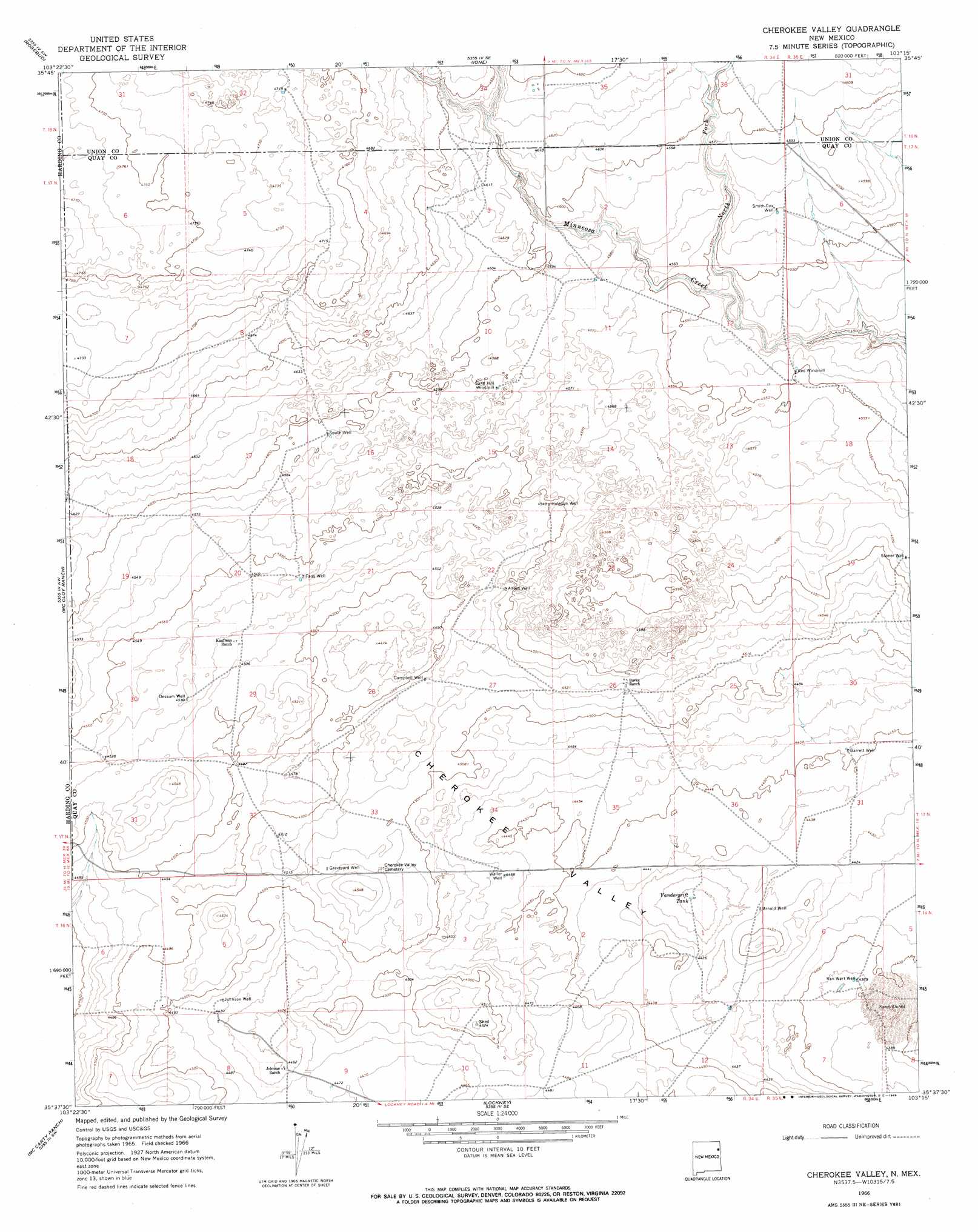
Cherokee Valley Topo Map New Mexico
To zoom in, hover over the map of Cherokee Valley
USGS Topo Quad 35103f3 - 1:24,000 scale
| Topo Map Name: | Cherokee Valley |
| USGS Topo Quad ID: | 35103f3 |
| Print Size: | ca. 21 1/4" wide x 27" high |
| Southeast Coordinates: | 35.625° N latitude / 103.25° W longitude |
| Map Center Coordinates: | 35.6875° N latitude / 103.3125° W longitude |
| U.S. State: | NM |
| Filename: | o35103f3.jpg |
| Download Map JPG Image: | Cherokee Valley topo map 1:24,000 scale |
| Map Type: | Topographic |
| Topo Series: | 7.5´ |
| Map Scale: | 1:24,000 |
| Source of Map Images: | United States Geological Survey (USGS) |
| Alternate Map Versions: |
Cherokee Valley NM 1966, updated 1969 Download PDF Buy paper map Cherokee Valley NM 2010 Download PDF Buy paper map Cherokee Valley NM 2013 Download PDF Buy paper map Cherokee Valley NM 2017 Download PDF Buy paper map |
1:24,000 Topo Quads surrounding Cherokee Valley
Bueyeros Ne |
Cottonwood Springs |
Hayden |
Amistad |
Koger Ranch |
Indian Bathtub |
Rosebud |
Ione |
Centerville Corner |
Amistad Se |
Gallegos Ne |
Mccloy Ranch |
Cherokee Valley |
Kerlin Hill |
Doyle Hill |
Fuentes Ranch |
Mccarty Ranch |
Lockney |
Obar |
Nara Visa |
Montesito Creek |
Logan North |
Logan Ne |
Cammak Camp |
Sanchez Springs |
> Back to 35103e1 at 1:100,000 scale
> Back to 35102a1 at 1:250,000 scale
> Back to U.S. Topo Maps home
Cherokee Valley topo map: Gazetteer
Cherokee Valley: Airports
Camco Ranch Airport elevation 1353m 4438′Cherokee Valley: Areas
Cherokee Valley elevation 1358m 4455′Cherokee Valley: Reservoirs
Vandergrift Tank elevation 1344m 4409′Cherokee Valley: Streams
North Fork Minneosa Creek elevation 1377m 4517′Cherokee Valley: Wells
00202 Water Well elevation 1408m 4619′05286 Water Well elevation 1349m 4425′
05287 Water Well elevation 1372m 4501′
05318 Water Well elevation 1392m 4566′
05319 Water Well elevation 1406m 4612′
05320 Water Well elevation 1399m 4589′
05321 Water Well elevation 1378m 4520′
05322 Water Well elevation 1367m 4484′
05324 Water Well elevation 1390m 4560′
05325 Water Well elevation 1381m 4530′
05326 Water Well elevation 1356m 4448′
05328 Water Well elevation 1387m 4550′
05340 Water Well elevation 1372m 4501′
05354 Water Well elevation 1399m 4589′
05359 Water Well elevation 1356m 4448′
05442 Water Well elevation 1351m 4432′
05443 Water Well elevation 1365m 4478′
05444 Water Well elevation 1357m 4452′
Alford Well elevation 1385m 4543′
Arnold Well elevation 1354m 4442′
Campbell Well elevation 1377m 4517′
Dessum Well elevation 1381m 4530′
Faus Well elevation 1385m 4543′
Garrett Well elevation 1358m 4455′
Graveyard Well elevation 1377m 4517′
Holcolm Well elevation 1384m 4540′
Johnson Well elevation 1367m 4484′
Smith-Cox Well elevation 1393m 4570′
South Well elevation 1400m 4593′
Stoner Well elevation 1395m 4576′
Van Wart Well elevation 1338m 4389′
Waller Well elevation 1362m 4468′
Cherokee Valley digital topo map on disk
Buy this Cherokee Valley topo map showing relief, roads, GPS coordinates and other geographical features, as a high-resolution digital map file on DVD: