Nara Visa Topo Map New Mexico
To zoom in, hover over the map of Nara Visa
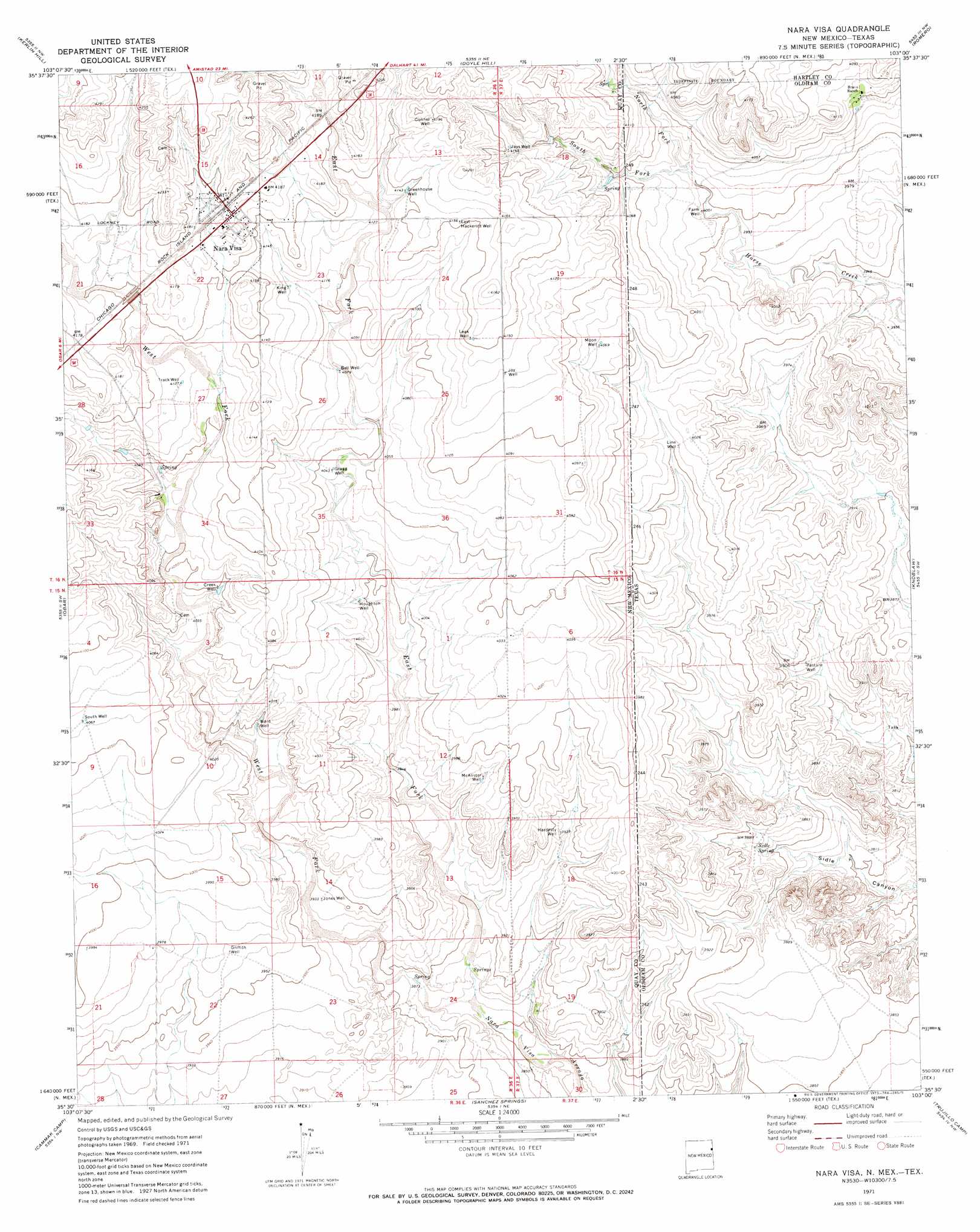
USGS Topo Quad 35103e1 - 1:24,000 scale
| Topo Map Name: | Nara Visa |
| USGS Topo Quad ID: | 35103e1 |
| Print Size: | ca. 21 1/4" wide x 27" high |
| Southeast Coordinates: | 35.5° N latitude / 103° W longitude |
| Map Center Coordinates: | 35.5625° N latitude / 103.0625° W longitude |
| U.S. States: | NM, TX |
| Filename: | o35103e1.jpg |
| Download Map JPG Image: | Nara Visa topo map 1:24,000 scale |
| Map Type: | Topographic |
| Topo Series: | 7.5´ |
| Map Scale: | 1:24,000 |
| Source of Map Images: | United States Geological Survey (USGS) |
| Alternate Map Versions: |
Nara Visa NM 1971, updated 1973 Download PDF Buy paper map Nara Visa NM 2010 Download PDF Buy paper map Nara Visa NM 2013 Download PDF Buy paper map Nara Visa NM 2017 Download PDF Buy paper map |
1:24,000 Topo Quads surrounding Nara Visa
Ione |
Centerville Corner |
Amistad Se |
Whiteaker Ranch |
Middle Water |
Cherokee Valley |
Kerlin Hill |
Doyle Hill |
Romero |
Spring Creek Ranch |
Lockney |
Obar |
Nara Visa |
Knoblaw |
Romero Se |
Logan Ne |
Cammak Camp |
Sanchez Springs |
Trujillo Camp |
Vat Camp |
Tuscocoillo Canyon |
Blue Hole |
Martin Draw |
Signal Spring |
Signal Spring Se |
> Back to 35103e1 at 1:100,000 scale
> Back to 35102a1 at 1:250,000 scale
> Back to U.S. Topo Maps home
Nara Visa topo map: Gazetteer
Nara Visa: Populated Places
Nara Visa elevation 1272m 4173′Nara Visa: Post Offices
Nara Visa Post Office elevation 1272m 4173′Nara Visa: Springs
Sidle Spring elevation 1180m 3871′Nara Visa: Streams
East Fork Nara Visa Arroyo elevation 1177m 3861′North Fork Horse Creek elevation 1222m 4009′
North Fork Horse Creek elevation 1222m 4009′
South Fork Horse Creek elevation 1222m 4009′
South Fork Horse Creek elevation 1222m 4009′
West Fork Nara Visa Arroyo elevation 1177m 3861′
Nara Visa: Wells
00100 Water Well elevation 1268m 4160′05082 Water Well elevation 1261m 4137′
05131 Water Well elevation 1268m 4160′
05274 Water Well elevation 1180m 3871′
05275 Water Well elevation 1231m 4038′
05276 Water Well elevation 1205m 3953′
05277 Water Well elevation 1196m 3923′
05278 Water Well elevation 1187m 3894′
05279 Water Well elevation 1171m 3841′
05280 Water Well elevation 1170m 3838′
05303 Water Well elevation 1278m 4192′
05304 Water Well elevation 1275m 4183′
05305 Water Well elevation 1275m 4183′
05306 Water Well elevation 1277m 4189′
05310 Water Well elevation 1268m 4160′
05311 Water Well elevation 1269m 4163′
05312 Water Well elevation 1262m 4140′
05314 Water Well elevation 1247m 4091′
05457 Water Well elevation 1266m 4153′
05458 Water Well elevation 1274m 4179′
05459 Water Well elevation 1292m 4238′
05460 Water Well elevation 1275m 4183′
05461 Water Well elevation 1266m 4153′
05462 Water Well elevation 1256m 4120′
05463 Water Well elevation 1267m 4156′
05464 Water Well elevation 1261m 4137′
05465 Water Well elevation 1255m 4117′
05467 Water Well elevation 1231m 4038′
05470 Water Well elevation 1244m 4081′
05471 Water Well elevation 1257m 4124′
05472 Water Well elevation 1222m 4009′
05473 Water Well elevation 1242m 4074′
05480 Water Well elevation 1239m 4064′
05481 Water Well elevation 1239m 4064′
05482 Water Well elevation 1204m 3950′
05483 Water Well elevation 1215m 3986′
05484 Water Well elevation 1202m 3943′
05485 Water Well elevation 1208m 3963′
Farm Well elevation 1219m 3999′
Line Well elevation 1223m 4012′
Pasture Well elevation 1187m 3894′
Nara Visa digital topo map on disk
Buy this Nara Visa topo map showing relief, roads, GPS coordinates and other geographical features, as a high-resolution digital map file on DVD: