Kerlin Hill Topo Map New Mexico
To zoom in, hover over the map of Kerlin Hill
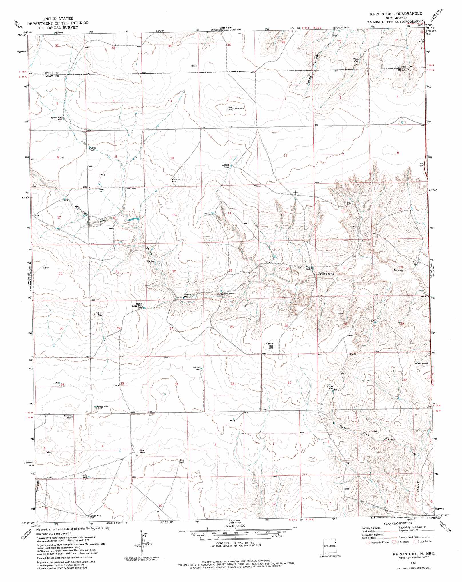
USGS Topo Quad 35103f2 - 1:24,000 scale
| Topo Map Name: | Kerlin Hill |
| USGS Topo Quad ID: | 35103f2 |
| Print Size: | ca. 21 1/4" wide x 27" high |
| Southeast Coordinates: | 35.625° N latitude / 103.125° W longitude |
| Map Center Coordinates: | 35.6875° N latitude / 103.1875° W longitude |
| U.S. State: | NM |
| Filename: | o35103f2.jpg |
| Download Map JPG Image: | Kerlin Hill topo map 1:24,000 scale |
| Map Type: | Topographic |
| Topo Series: | 7.5´ |
| Map Scale: | 1:24,000 |
| Source of Map Images: | United States Geological Survey (USGS) |
| Alternate Map Versions: |
Kerlin Hill NM 1971, updated 1972 Download PDF Buy paper map Kerlin Hill NM 1971, updated 1982 Download PDF Buy paper map Kerlin Hill NM 2010 Download PDF Buy paper map Kerlin Hill NM 2013 Download PDF Buy paper map Kerlin Hill NM 2017 Download PDF Buy paper map |
1:24,000 Topo Quads surrounding Kerlin Hill
Cottonwood Springs |
Hayden |
Amistad |
Koger Ranch |
Beck Ranch |
Rosebud |
Ione |
Centerville Corner |
Amistad Se |
Whiteaker Ranch |
Mccloy Ranch |
Cherokee Valley |
Kerlin Hill |
Doyle Hill |
Romero |
Mccarty Ranch |
Lockney |
Obar |
Nara Visa |
Knoblaw |
Logan North |
Logan Ne |
Cammak Camp |
Sanchez Springs |
Trujillo Camp |
> Back to 35103e1 at 1:100,000 scale
> Back to 35102a1 at 1:250,000 scale
> Back to U.S. Topo Maps home
Kerlin Hill topo map: Gazetteer
Kerlin Hill: Reservoirs
Logan Tank elevation 1382m 4534′Kerlin Hill: Summits
Kerlin Hill elevation 1376m 4514′Kerlin Hill: Wells
00064 Water Well elevation 1361m 4465′05284 Water Well elevation 1323m 4340′
05297 Water Well elevation 1329m 4360′
05329 Water Well elevation 1380m 4527′
05330 Water Well elevation 1367m 4484′
05331 Water Well elevation 1369m 4491′
05332 Water Well elevation 1365m 4478′
05339 Water Well elevation 1334m 4376′
05341 Water Well elevation 1343m 4406′
05350 Water Well elevation 1351m 4432′
05356 Water Well elevation 1373m 4504′
05357 Water Well elevation 1342m 4402′
05358 Water Well elevation 1365m 4478′
05367 Water Well elevation 1338m 4389′
05456 Water Well elevation 1294m 4245′
East Well elevation 1326m 4350′
Gillette Well elevation 1345m 4412′
Gregg Well elevation 1342m 4402′
Home Well elevation 1331m 4366′
Howery Well elevation 1344m 4409′
Kuper Well elevation 1350m 4429′
Larson Well elevation 1330m 4363′
Laycock Well elevation 1381m 4530′
North Gregg Well elevation 1365m 4478′
Wallace Well elevation 1348m 4422′
Watts Well elevation 1321m 4333′
West Well elevation 1327m 4353′
Whitaker Well elevation 1372m 4501′
White Well elevation 1371m 4498′
Wise Well elevation 1355m 4445′
Kerlin Hill digital topo map on disk
Buy this Kerlin Hill topo map showing relief, roads, GPS coordinates and other geographical features, as a high-resolution digital map file on DVD: