Arroyo Del Alamo Topo Map New Mexico
To zoom in, hover over the map of Arroyo Del Alamo
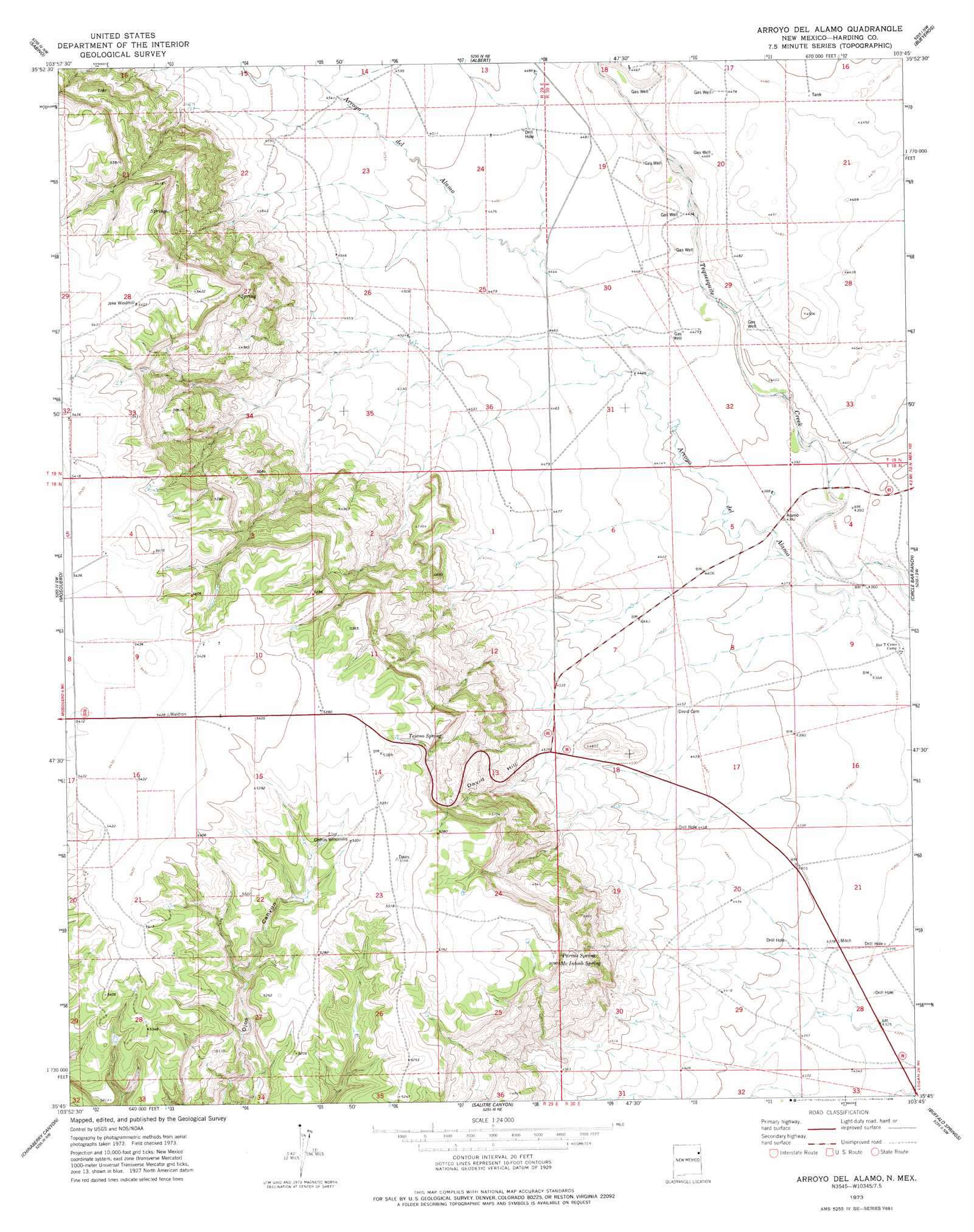
USGS Topo Quad 35103g7 - 1:24,000 scale
| Topo Map Name: | Arroyo Del Alamo |
| USGS Topo Quad ID: | 35103g7 |
| Print Size: | ca. 21 1/4" wide x 27" high |
| Southeast Coordinates: | 35.75° N latitude / 103.75° W longitude |
| Map Center Coordinates: | 35.8125° N latitude / 103.8125° W longitude |
| U.S. State: | NM |
| Filename: | o35103g7.jpg |
| Download Map JPG Image: | Arroyo Del Alamo topo map 1:24,000 scale |
| Map Type: | Topographic |
| Topo Series: | 7.5´ |
| Map Scale: | 1:24,000 |
| Source of Map Images: | United States Geological Survey (USGS) |
| Alternate Map Versions: |
Arroyo Del Alamo NM 1973, updated 1978 Download PDF Buy paper map Arroyo Del Alamo NM 2010 Download PDF Buy paper map Arroyo Del Alamo NM 2013 Download PDF Buy paper map Arroyo Del Alamo NM 2017 Download PDF Buy paper map |
1:24,000 Topo Quads surrounding Arroyo Del Alamo
Kansas Valley |
Valencia Spring |
Yates Se |
Beenham Sw |
Minnie Butte |
Kansas Valley Lake |
Sabino |
Albert |
Bueyeros |
Bueyeros Ne |
Solano |
Mosquero |
Arroyo Del Alamo |
Circle Bar Ranch |
Indian Bathtub |
Waggoner Ranch |
Chinaberry Canyon |
Salitre Canyon |
Buffalo Springs |
Gallegos Ne |
Bell Ranch |
Campana |
Alamosa Canyon |
Gallegos |
Fuentes Ranch |
> Back to 35103e1 at 1:100,000 scale
> Back to 35102a1 at 1:250,000 scale
> Back to U.S. Topo Maps home
Arroyo Del Alamo topo map: Gazetteer
Arroyo Del Alamo: Mines
Amerigas Number Sixteen Mitchell elevation 1343m 4406′Amerigas Number Twenty Mitchell elevation 1343m 4406′
Amoco Number One State FM elevation 1373m 4504′
Carbonic Number Five Mitchell elevation 1368m 4488′
Carbonic Number Seven Mitchell elevation 1351m 4432′
Carbonic Number Thirteen Mitchell elevation 1348m 4422′
Carbonic Number Three Mitchell elevation 1360m 4461′
Arroyo Del Alamo: Springs
McIntosh Spring elevation 1546m 5072′Parras Spring elevation 1544m 5065′
Tejano Spring elevation 1572m 5157′
Arroyo Del Alamo: Summits
David Hill elevation 1460m 4790′Arroyo Del Alamo: Wells
CO 2 Well elevation 1364m 4475′CO 2 Well elevation 1349m 4425′
Arroyo Del Alamo digital topo map on disk
Buy this Arroyo Del Alamo topo map showing relief, roads, GPS coordinates and other geographical features, as a high-resolution digital map file on DVD: