Antelope Lookout Mesa Topo Map New Mexico
To zoom in, hover over the map of Antelope Lookout Mesa
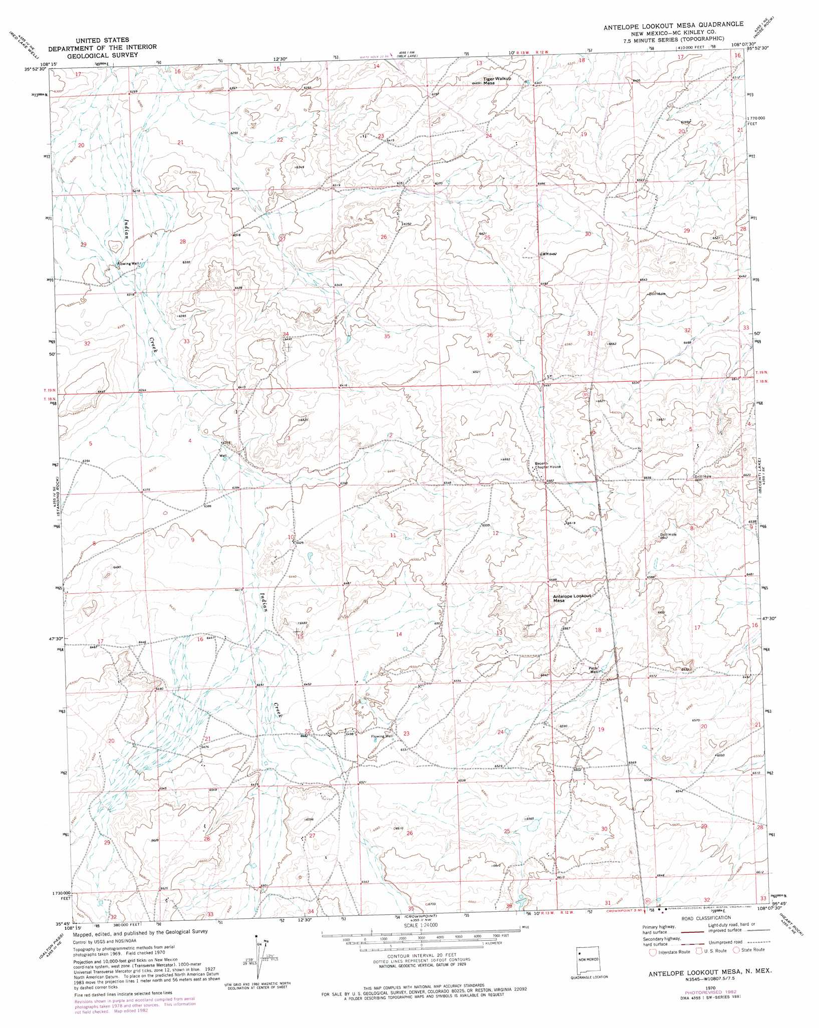
USGS Topo Quad 35108g2 - 1:24,000 scale
| Topo Map Name: | Antelope Lookout Mesa |
| USGS Topo Quad ID: | 35108g2 |
| Print Size: | ca. 21 1/4" wide x 27" high |
| Southeast Coordinates: | 35.75° N latitude / 108.125° W longitude |
| Map Center Coordinates: | 35.8125° N latitude / 108.1875° W longitude |
| U.S. State: | NM |
| Filename: | o35108g2.jpg |
| Download Map JPG Image: | Antelope Lookout Mesa topo map 1:24,000 scale |
| Map Type: | Topographic |
| Topo Series: | 7.5´ |
| Map Scale: | 1:24,000 |
| Source of Map Images: | United States Geological Survey (USGS) |
| Alternate Map Versions: |
Antelope Lookout Mesa NM 1970, updated 1973 Download PDF Buy paper map Antelope Lookout Mesa NM 1970, updated 1982 Download PDF Buy paper map Antelope Lookout Mesa NM 2010 Download PDF Buy paper map Antelope Lookout Mesa NM 2013 Download PDF Buy paper map Antelope Lookout Mesa NM 2017 Download PDF Buy paper map |
1:24,000 Topo Quads surrounding Antelope Lookout Mesa
The Pillar 2 Sw |
The Pillar 3 Se |
La Vida Mission |
Kin Klizhin Ruins |
Pueblo Bonito |
Standing Rock Nw |
Red Lake Well |
Milk Lake |
Nose Rock |
Seven Lakes Nw |
Toyee |
Standing Rock |
Antelope Lookout Mesa |
Becenti Lake |
Seven Lakes |
Oak Spring |
Dalton Pass |
Crownpoint |
Heart Rock |
Laguna Castillo |
Pinedale |
Mariano Lake |
Hosta Butte |
Casamero Lake |
Borrego Pass |
> Back to 35108e1 at 1:100,000 scale
> Back to 35108a1 at 1:250,000 scale
> Back to U.S. Topo Maps home
Antelope Lookout Mesa topo map: Gazetteer
Antelope Lookout Mesa: Summits
Antelope Lookout Mesa elevation 2069m 6788′Tiger Walkup Mesa elevation 1963m 6440′
Antelope Lookout Mesa: Valleys
Dalton Pass Canyon elevation 1987m 6519′Antelope Lookout Mesa: Wells
15K-336 Water Well elevation 1940m 6364′15T-516 Water Well elevation 1988m 6522′
15T-544 Water Well elevation 2042m 6699′
19-12-32-W3 Water Well elevation 1970m 6463′
Artesian Number 6 Water Well elevation 1977m 6486′
SJ-109-S-11 Water Well elevation 1974m 6476′
SJ-109-S-12 Water Well elevation 1966m 6450′
SJ-109-S-12-0 Water Well elevation 1969m 6459′
SJ-109-S-12-0-3 Water Well elevation 1970m 6463′
SJ-109-S-12-0-4 Water Well elevation 1968m 6456′
SJ-109-S-3 Water Well elevation 2007m 6584′
SJ-109-S-9 Water Well elevation 1995m 6545′
SJ-772 Water Well elevation 1987m 6519′
SJ-902-0-1 Water Well elevation 1971m 6466′
SJ-902-0-2 Water Well elevation 1969m 6459′
SJ-902-0-3 Water Well elevation 1971m 6466′
Antelope Lookout Mesa digital topo map on disk
Buy this Antelope Lookout Mesa topo map showing relief, roads, GPS coordinates and other geographical features, as a high-resolution digital map file on DVD: