Cave Mountain Topo Map California
To zoom in, hover over the map of Cave Mountain
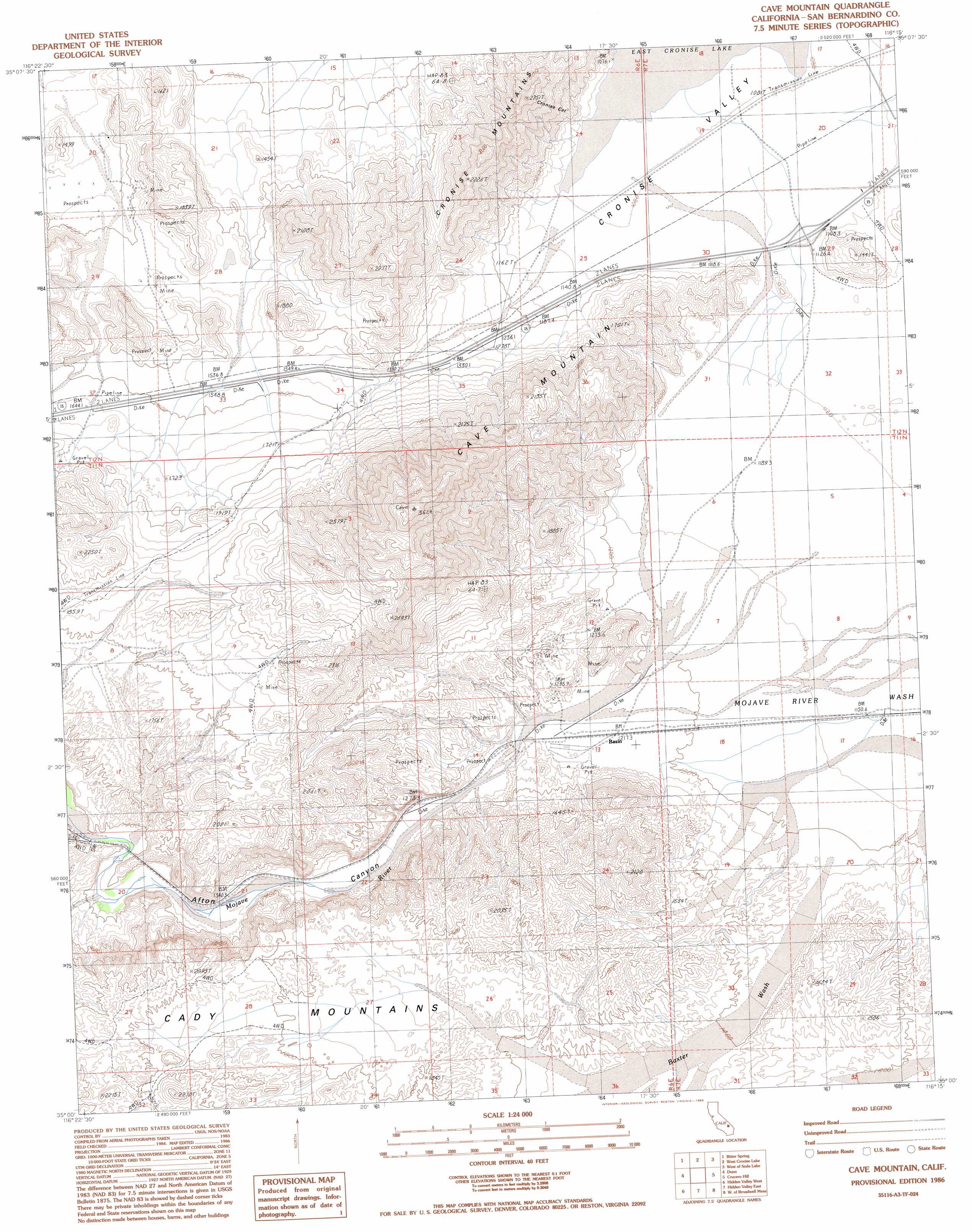
USGS Topo Quad 35116a3 - 1:24,000 scale
| Topo Map Name: | Cave Mountain |
| USGS Topo Quad ID: | 35116a3 |
| Print Size: | ca. 21 1/4" wide x 27" high |
| Southeast Coordinates: | 35° N latitude / 116.25° W longitude |
| Map Center Coordinates: | 35.0625° N latitude / 116.3125° W longitude |
| U.S. State: | CA |
| Filename: | o35116a3.jpg |
| Download Map JPG Image: | Cave Mountain topo map 1:24,000 scale |
| Map Type: | Topographic |
| Topo Series: | 7.5´ |
| Map Scale: | 1:24,000 |
| Source of Map Images: | United States Geological Survey (USGS) |
| Alternate Map Versions: |
Cave Mountain CA 1986, updated 1986 Download PDF Buy paper map Cave Mountain CA 1986, updated 1993 Download PDF Buy paper map Cave Mountain CA 1996, updated 2000 Download PDF Buy paper map Cave Mountain CA 2012 Download PDF Buy paper map Cave Mountain CA 2015 Download PDF Buy paper map |
1:24,000 Topo Quads surrounding Cave Mountain
Tiefort Mountains |
West Of Red Pass Lake |
Red Pass Lake |
West Of Baker |
Baker |
East Of Langford Well |
Bitter Spring |
Cronise Lakes |
West Of Soda Lake |
Soda Lake North |
Alvord Mountain East |
Dunn |
Cave Mountain |
Crucero Hill |
Soda Lake South |
Manix |
Hidden Valley West |
Hidden Valley East |
West Of Broadwell Mesa |
Broadwell Mesa |
Troy Lake |
Hector |
Sleeping Beauty |
Broadwell Lake |
East Of Broadwell Lake |
> Back to 35116a1 at 1:100,000 scale
> Back to 35116a1 at 1:250,000 scale
> Back to U.S. Topo Maps home
Cave Mountain topo map: Gazetteer
Cave Mountain: Basins
Cronise Valley elevation 332m 1089′Cave Mountain: Populated Places
Basin elevation 374m 1227′Baxter (historical) elevation 369m 1210′
Cronese Valley elevation 341m 1118′
Cronise (historical) elevation 331m 1085′
Cave Mountain: Ridges
Cronise Mountains elevation 580m 1902′Cave Mountain: Streams
Baxter Wash elevation 374m 1227′Cave Mountain: Summits
Cave Mountain elevation 1073m 3520′Cave Mountain: Valleys
Afton Canyon elevation 367m 1204′Cave Mountain digital topo map on disk
Buy this Cave Mountain topo map showing relief, roads, GPS coordinates and other geographical features, as a high-resolution digital map file on DVD:
Southern Sierra Nevada, California & Southern Nevada
Buy digital topo maps: Southern Sierra Nevada, California & Southern Nevada