West Sandy Dike Topo Map Tennessee
To zoom in, hover over the map of West Sandy Dike
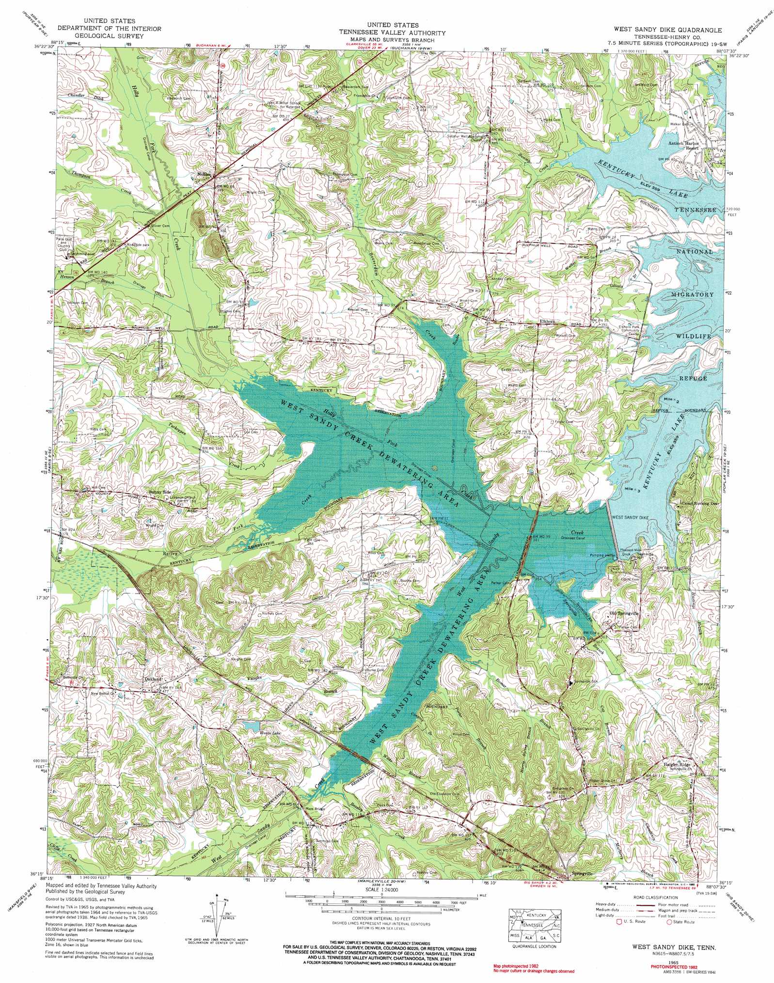
USGS Topo Quad 36088c2 - 1:24,000 scale
| Topo Map Name: | West Sandy Dike |
| USGS Topo Quad ID: | 36088c2 |
| Print Size: | ca. 21 1/4" wide x 27" high |
| Southeast Coordinates: | 36.25° N latitude / 88.125° W longitude |
| Map Center Coordinates: | 36.3125° N latitude / 88.1875° W longitude |
| U.S. State: | TN |
| Filename: | o36088c2.jpg |
| Download Map JPG Image: | West Sandy Dike topo map 1:24,000 scale |
| Map Type: | Topographic |
| Topo Series: | 7.5´ |
| Map Scale: | 1:24,000 |
| Source of Map Images: | United States Geological Survey (USGS) |
| Alternate Map Versions: |
Springville TN 1936 Download PDF Buy paper map Springville TN 1938 Download PDF Buy paper map Springville TN 1938, updated 1963 Download PDF Buy paper map West Sandy Dike TN 1965, updated 1967 Download PDF Buy paper map West Sandy Dike TN 1965, updated 1990 Download PDF Buy paper map West Sandy Dike TN 2010 Download PDF Buy paper map West Sandy Dike TN 2013 Download PDF Buy paper map West Sandy Dike TN 2016 Download PDF Buy paper map |
1:24,000 Topo Quads surrounding West Sandy Dike
Lynn Grove |
Murray |
New Concord |
Hamlin |
Tharpe |
Cottage Grove |
Puryear |
Buchanan |
Paris Landing |
Standing Rock |
Osage |
Paris |
West Sandy Dike |
Poplar Creek |
Mckinnon |
Henry |
Mansfield |
Manleyville |
Big Sandy |
Harmon Creek |
Huntingdon |
Vale |
Bruceton |
Camden |
Johnsonville |
> Back to 36088a1 at 1:100,000 scale
> Back to 36088a1 at 1:250,000 scale
> Back to U.S. Topo Maps home
West Sandy Dike topo map: Gazetteer
West Sandy Dike: Basins
West Sandy Creek Dewatering Area elevation 106m 347′West Sandy Dike: Bridges
Mays Bridge elevation 109m 357′Parker Bridge (historical) elevation 107m 351′
West Sandy Dike: Canals
West Sandy Creek Drainage Ditch elevation 108m 354′West Sandy Dike: Dams
Weaks Lake Dam elevation 134m 439′West Sandy Dike elevation 109m 357′
West Sandy Dike: Parks
Big Sandy Unit Tennessee National Wildlife Refuge elevation 113m 370′Greenhead Recreation Area elevation 110m 360′
West Sandy Wildlife Management Area elevation 108m 354′
West Sandy Dike: Populated Places
Antioch Harbor Resort elevation 117m 383′Elkhorn elevation 131m 429′
Haigler Ridge elevation 133m 436′
Nobles elevation 135m 442′
Oakland elevation 144m 472′
Old Springville elevation 116m 380′
Porters (historical) elevation 116m 380′
Sunny Side elevation 136m 446′
West Sandy Dike: Post Offices
Springville Post Office elevation 150m 492′West Sandy Dike: Reservoirs
Twin Lakes elevation 134m 439′Weaks Lake elevation 129m 423′
West Sandy Dike: Streams
Bailey Fork Creek elevation 107m 351′Beasley Creek elevation 109m 357′
Beaverdam Creek elevation 107m 351′
Bomar Branch elevation 108m 354′
Bowles Branch elevation 107m 351′
Chandler Ditch elevation 113m 370′
Conyers Branch elevation 109m 357′
Cox Branch elevation 112m 367′
Gillooly Branch elevation 110m 360′
Grudge Ditch elevation 110m 360′
Harris Spring Branch elevation 117m 383′
Hastings Branch elevation 109m 357′
Henson Branch elevation 110m 360′
Holly Fork Creek elevation 106m 347′
Porter Branch elevation 108m 354′
Spring Creek elevation 109m 357′
Springville Branch elevation 106m 347′
Swamp Creek elevation 109m 357′
Thompson Creek elevation 112m 367′
Turkeypen Creek elevation 108m 354′
Vaughn Branch elevation 108m 354′
Wade Branch elevation 109m 357′
Walker Branch elevation 110m 360′
West Sandy Dike: Swamps
Sulphur Well Swamp (historical) elevation 109m 357′West Sandy Dike digital topo map on disk
Buy this West Sandy Dike topo map showing relief, roads, GPS coordinates and other geographical features, as a high-resolution digital map file on DVD: