Bloomfield Topo Map Missouri
To zoom in, hover over the map of Bloomfield
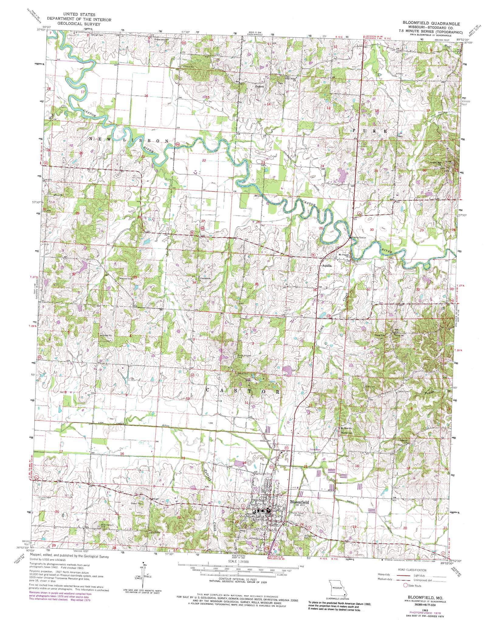
USGS Topo Quad 36089h8 - 1:24,000 scale
| Topo Map Name: | Bloomfield |
| USGS Topo Quad ID: | 36089h8 |
| Print Size: | ca. 21 1/4" wide x 27" high |
| Southeast Coordinates: | 36.875° N latitude / 89.875° W longitude |
| Map Center Coordinates: | 36.9375° N latitude / 89.9375° W longitude |
| U.S. State: | MO |
| Filename: | o36089h8.jpg |
| Download Map JPG Image: | Bloomfield topo map 1:24,000 scale |
| Map Type: | Topographic |
| Topo Series: | 7.5´ |
| Map Scale: | 1:24,000 |
| Source of Map Images: | United States Geological Survey (USGS) |
| Alternate Map Versions: |
Bloomfield MO 1963, updated 1964 Download PDF Buy paper map Bloomfield MO 1963, updated 1979 Download PDF Buy paper map Bloomfield MO 1963, updated 1986 Download PDF Buy paper map Bloomfield MO 2012 Download PDF Buy paper map Bloomfield MO 2015 Download PDF Buy paper map |
1:24,000 Topo Quads surrounding Bloomfield
Gipsy |
Zalma |
Dongola |
Whitewater |
Chaffee |
Mcgee |
Sturdivant |
Advance |
Bell City |
Oran |
Puxico |
Acorn Ridge |
Bloomfield |
Clines Island |
Vanduser |
Fisk |
Dudley |
Dexter |
Essex |
Morehouse |
Broseley |
Powe |
Bernie |
Hills Store |
Charter Oak |
> Back to 36089e1 at 1:100,000 scale
> Back to 36088a1 at 1:250,000 scale
> Back to U.S. Topo Maps home
Bloomfield topo map: Gazetteer
Bloomfield: Dams
Hendley Lake Dam elevation 105m 344′Whites Lake Dam elevation 126m 413′
Bloomfield: Populated Places
Aquilla elevation 110m 360′Bloomfield elevation 147m 482′
Old Shawnee Village (historical) elevation 117m 383′
Zadock elevation 134m 439′
Bloomfield: Reservoirs
Joe Hendley Lake elevation 105m 344′Whites Lake elevation 126m 413′
Bloomfield: Streams
Link Creek elevation 97m 318′Mud Creek elevation 100m 328′
Tedrick Creek elevation 119m 390′
Bloomfield digital topo map on disk
Buy this Bloomfield topo map showing relief, roads, GPS coordinates and other geographical features, as a high-resolution digital map file on DVD: