Ravenden Springs Se Topo Map Arkansas
To zoom in, hover over the map of Ravenden Springs Se
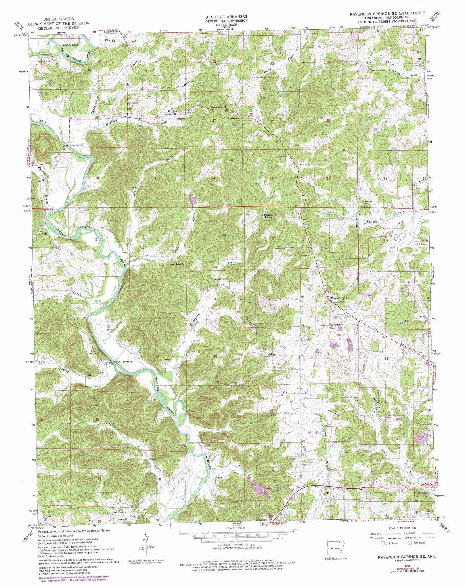
USGS Topo Quad 36091c1 - 1:24,000 scale
| Topo Map Name: | Ravenden Springs Se |
| USGS Topo Quad ID: | 36091c1 |
| Print Size: | ca. 21 1/4" wide x 27" high |
| Southeast Coordinates: | 36.25° N latitude / 91° W longitude |
| Map Center Coordinates: | 36.3125° N latitude / 91.0625° W longitude |
| U.S. State: | AR |
| Filename: | o36091c1.jpg |
| Download Map JPG Image: | Ravenden Springs Se topo map 1:24,000 scale |
| Map Type: | Topographic |
| Topo Series: | 7.5´ |
| Map Scale: | 1:24,000 |
| Source of Map Images: | United States Geological Survey (USGS) |
| Alternate Map Versions: |
Ravenden Springs SE AR 1966, updated 1967 Download PDF Buy paper map Ravenden Springs SE AR 1966, updated 1982 Download PDF Buy paper map Ravenden Springs SE AR 2011 Download PDF Buy paper map Ravenden Springs SE AR 2014 Download PDF Buy paper map |
1:24,000 Topo Quads surrounding Ravenden Springs Se
Myrtle |
Billmore |
Gatewood |
Poynor |
Doniphan South |
Hardy Ne |
Dalton |
Warm Springs |
Maynard |
Supply |
Williford |
Ravenden Springs |
Ravenden Springs Se |
Pocahontas |
Reyno |
Ravenden |
Imboden |
Noland |
Manson |
O'Kean |
Smithville |
Eaton |
Black Rock |
Walnut Ridge |
Walnut Ridge Se |
> Back to 36091a1 at 1:100,000 scale
> Back to 36090a1 at 1:250,000 scale
> Back to U.S. Topo Maps home
Ravenden Springs Se topo map: Gazetteer
Ravenden Springs Se: Bridges
Black Ferry Bridge elevation 92m 301′Ravenden Springs Se: Dams
Blue Basin Lake Dam elevation 98m 321′Lost Lake Dam elevation 131m 429′
Ravenden Springs Se: Lakes
Looney Lake elevation 95m 311′Ravenden Springs Se: Populated Places
Gravesville elevation 159m 521′Lorine elevation 144m 472′
Stoney Point elevation 134m 439′
Ravenden Springs Se: Reservoirs
Blue Basin Lake elevation 98m 321′Lost Lake elevation 131m 429′
Ravenden Springs Se: Springs
Coldwater Spring elevation 121m 396′Fivemile Spring elevation 136m 446′
Ravenden Springs Se: Streams
Allred Creek elevation 83m 272′Bradley Creek elevation 89m 291′
Eassis Creek elevation 86m 282′
Jew Creek elevation 88m 288′
McIlroy Creek elevation 93m 305′
Powell Creek elevation 85m 278′
River Creek elevation 86m 282′
Ross Creek elevation 109m 357′
Tattle Creek elevation 86m 282′
Thatch Creek elevation 105m 344′
Thompson Creek elevation 86m 282′
Vandergriff Creek elevation 90m 295′
Ravenden Springs Se: Summits
Cooley Hill elevation 165m 541′Ravenden Springs Se digital topo map on disk
Buy this Ravenden Springs Se topo map showing relief, roads, GPS coordinates and other geographical features, as a high-resolution digital map file on DVD: