Green Forest Topo Map Arkansas
To zoom in, hover over the map of Green Forest
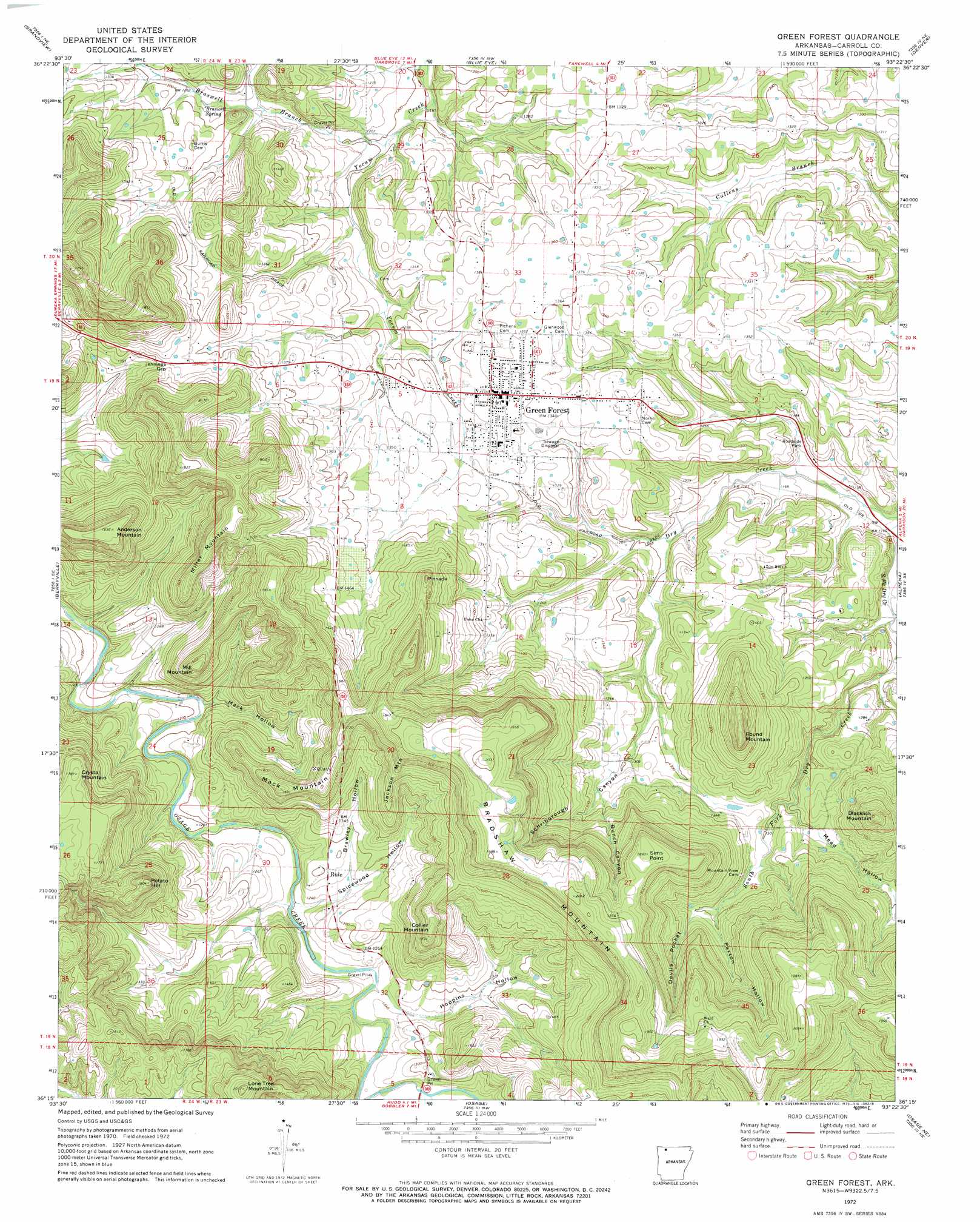
USGS Topo Quad 36093c4 - 1:24,000 scale
| Topo Map Name: | Green Forest |
| USGS Topo Quad ID: | 36093c4 |
| Print Size: | ca. 21 1/4" wide x 27" high |
| Southeast Coordinates: | 36.25° N latitude / 93.375° W longitude |
| Map Center Coordinates: | 36.3125° N latitude / 93.4375° W longitude |
| U.S. State: | AR |
| Filename: | o36093c4.jpg |
| Download Map JPG Image: | Green Forest topo map 1:24,000 scale |
| Map Type: | Topographic |
| Topo Series: | 7.5´ |
| Map Scale: | 1:24,000 |
| Source of Map Images: | United States Geological Survey (USGS) |
| Alternate Map Versions: |
Green Forest AR 1972, updated 1973 Download PDF Buy paper map Green Forest AR 2011 Download PDF Buy paper map Green Forest AR 2014 Download PDF Buy paper map |
1:24,000 Topo Quads surrounding Green Forest
Golden |
Viola |
Lampe |
Table Rock Dam |
Hollister |
Eureka Springs |
Grandview |
Blue Eye |
Denver |
Omaha |
Rockhouse |
Berryville |
Green Forest |
Alpena |
Batavia |
Forum |
Marble |
Osage |
Osage Ne |
Gaither |
Huntsville |
Kingston |
Osage Sw |
Ponca |
Jasper |
> Back to 36093a1 at 1:100,000 scale
> Back to 36092a1 at 1:250,000 scale
> Back to U.S. Topo Maps home
Green Forest topo map: Gazetteer
Green Forest: Cliffs
Sims Point elevation 572m 1876′Green Forest: Forests
Green Forest elevation 405m 1328′Green Forest: Gaps
Jennings Gap elevation 433m 1420′Green Forest: Populated Places
Brasswell Spring (historical) elevation 384m 1259′Green Forest elevation 405m 1328′
New Town (historical) elevation 408m 1338′
Norton (historical) elevation 392m 1286′
Rule elevation 390m 1279′
Green Forest: Springs
Braswell Spring elevation 385m 1263′Green Forest: Streams
Braswell Branch elevation 360m 1181′Green Forest: Summits
Anderson Mountain elevation 552m 1811′Blacklick Mountain elevation 486m 1594′
Bradshaw Mountain elevation 609m 1998′
Collier Mountain elevation 518m 1699′
Crystal Mountain elevation 539m 1768′
Jackson Mountain elevation 513m 1683′
Lone Tree Mountain elevation 607m 1991′
Mack Mountain elevation 477m 1564′
Mill Mountain elevation 501m 1643′
Miller Mountain elevation 532m 1745′
Pinnacle elevation 503m 1650′
Potato Hill elevation 537m 1761′
Round Mountain elevation 496m 1627′
Green Forest: Valleys
Brawley Hollow elevation 384m 1259′Bunch Canyon elevation 451m 1479′
Devils Pocket elevation 436m 1430′
Hoppins Hollow elevation 378m 1240′
Mack Hollow elevation 367m 1204′
Mead Hollow elevation 399m 1309′
Paxton Hollow elevation 430m 1410′
Schriborough Canyon elevation 397m 1302′
Spicewood Hollow elevation 373m 1223′
Green Forest digital topo map on disk
Buy this Green Forest topo map showing relief, roads, GPS coordinates and other geographical features, as a high-resolution digital map file on DVD: