La Segita Peaks Topo Map New Mexico
To zoom in, hover over the map of La Segita Peaks
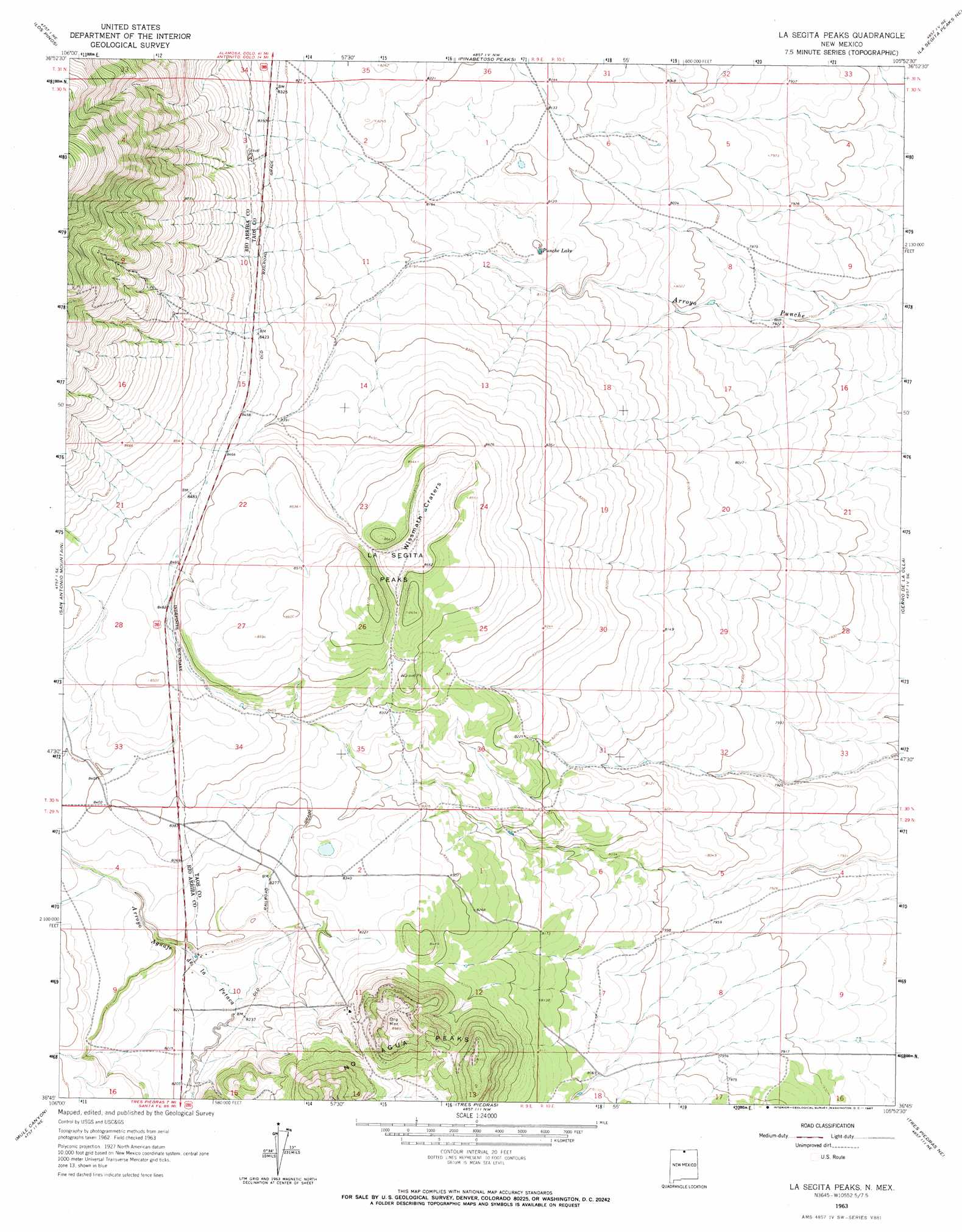
USGS Topo Quad 36105g8 - 1:24,000 scale
| Topo Map Name: | La Segita Peaks |
| USGS Topo Quad ID: | 36105g8 |
| Print Size: | ca. 21 1/4" wide x 27" high |
| Southeast Coordinates: | 36.75° N latitude / 105.875° W longitude |
| Map Center Coordinates: | 36.8125° N latitude / 105.9375° W longitude |
| U.S. State: | NM |
| Filename: | o36105g8.jpg |
| Download Map JPG Image: | La Segita Peaks topo map 1:24,000 scale |
| Map Type: | Topographic |
| Topo Series: | 7.5´ |
| Map Scale: | 1:24,000 |
| Source of Map Images: | United States Geological Survey (USGS) |
| Alternate Map Versions: |
La Segita Peaks NM 1963, updated 1967 Download PDF Buy paper map La Segita Peaks NM 2010 Download PDF Buy paper map La Segita Peaks NM 2013 Download PDF Buy paper map La Segita Peaks NM 2017 Download PDF Buy paper map |
1:24,000 Topo Quads surrounding La Segita Peaks
Fox Creek |
Antonito |
Lobatos |
Kiowa Hill |
Sky Valley Ranch |
Bighorn Peak |
Los Pinos |
Pinabetoso Peaks |
La Segita Peaks Ne |
Ute Mountain |
Broke Off Mountain |
San Antonio Mountain |
La Segita Peaks |
Cerro De La Olla |
Sunshine |
Burned Mountain |
Mule Canyon |
Tres Piedras |
Tres Piedras Ne |
Guadalupe Mountain |
Canon Plaza |
Las Tablas |
Petaca Peak |
Cerro De Los Taoses |
Arroyo Hondo |
> Back to 36105e1 at 1:100,000 scale
> Back to 36104a1 at 1:250,000 scale
> Back to U.S. Topo Maps home
La Segita Peaks topo map: Gazetteer
La Segita Peaks: Craters
Wissmath Craters elevation 2571m 8435′La Segita Peaks: Lakes
Punche Lake elevation 2470m 8103′La Segita Peaks: Mines
Black Scoria Mine elevation 2605m 8546′Johns Manville Perlite Corporation elevation 2544m 8346′
Johns-Manville Mine elevation 2572m 8438′
No Agua Mine elevation 2727m 8946′
United Perlite elevation 2553m 8375′
La Segita Peaks: Summits
La Segita Peaks elevation 2642m 8667′La Segita Peaks digital topo map on disk
Buy this La Segita Peaks topo map showing relief, roads, GPS coordinates and other geographical features, as a high-resolution digital map file on DVD: