Paraiso Springs Topo Map California
To zoom in, hover over the map of Paraiso Springs
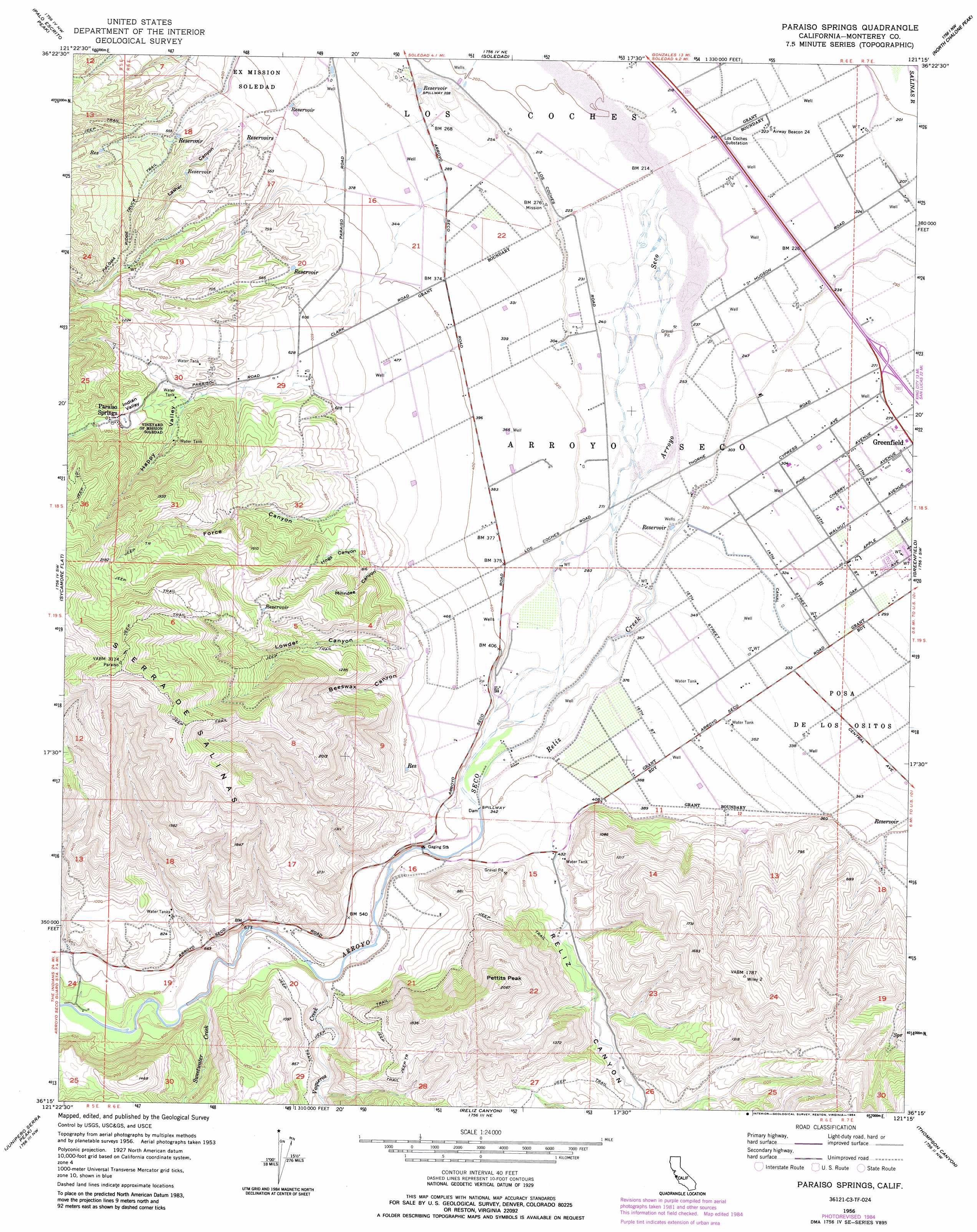
USGS Topo Quad 36121c3 - 1:24,000 scale
| Topo Map Name: | Paraiso Springs |
| USGS Topo Quad ID: | 36121c3 |
| Print Size: | ca. 21 1/4" wide x 27" high |
| Southeast Coordinates: | 36.25° N latitude / 121.25° W longitude |
| Map Center Coordinates: | 36.3125° N latitude / 121.3125° W longitude |
| U.S. State: | CA |
| Filename: | o36121c3.jpg |
| Download Map JPG Image: | Paraiso Springs topo map 1:24,000 scale |
| Map Type: | Topographic |
| Topo Series: | 7.5´ |
| Map Scale: | 1:24,000 |
| Source of Map Images: | United States Geological Survey (USGS) |
| Alternate Map Versions: |
Paraiso Springs CA 1956, updated 1958 Download PDF Buy paper map Paraiso Springs CA 1956, updated 1974 Download PDF Buy paper map Paraiso Springs CA 1956, updated 1984 Download PDF Buy paper map Paraiso Springs CA 2012 Download PDF Buy paper map Paraiso Springs CA 2015 Download PDF Buy paper map |
1:24,000 Topo Quads surrounding Paraiso Springs
Chualar |
Gonzales |
Mount Johnson |
Bickmore Canyon |
San Benito |
Rana Creek |
Palo Escrito Peak |
Soledad |
North Chalone Peak |
Topo Valley |
Chews Ridge |
Sycamore Flat |
Paraiso Springs |
Greenfield |
Pinalito Canyon |
Tassajara Hot Springs |
Junipero Serra Peak |
Reliz Canyon |
Thompson Canyon |
San Lucas |
Lopez Point |
Cone Peak |
Bear Canyon |
Cosio Knob |
Espinosa Canyon |
> Back to 36121a1 at 1:100,000 scale
> Back to 36120a1 at 1:250,000 scale
> Back to U.S. Topo Maps home
Paraiso Springs topo map: Gazetteer
Paraiso Springs: Airports
Clark Ranch Airport elevation 81m 265′Paraiso Springs: Basins
Indian Valley elevation 325m 1066′Paraiso Springs: Springs
Paraiso Springs elevation 346m 1135′Paraiso Springs: Streams
Reliz Creek elevation 84m 275′Sweetwater Creek elevation 122m 400′
Vaqueros Creek elevation 120m 393′
Paraiso Springs: Summits
Pettits Peak elevation 625m 2050′Paraiso Springs: Valleys
Beeswax Canyon elevation 193m 633′Force Canyon elevation 189m 620′
Happy Canyon elevation 255m 836′
Hogs Canyon elevation 175m 574′
Lasher Canyon elevation 158m 518′
Lowder Canyon elevation 159m 521′
Milindee Canyon elevation 175m 574′
Reliz Canyon elevation 105m 344′
Paraiso Springs digital topo map on disk
Buy this Paraiso Springs topo map showing relief, roads, GPS coordinates and other geographical features, as a high-resolution digital map file on DVD: