Tassajara Hot Springs Topo Map California
To zoom in, hover over the map of Tassajara Hot Springs
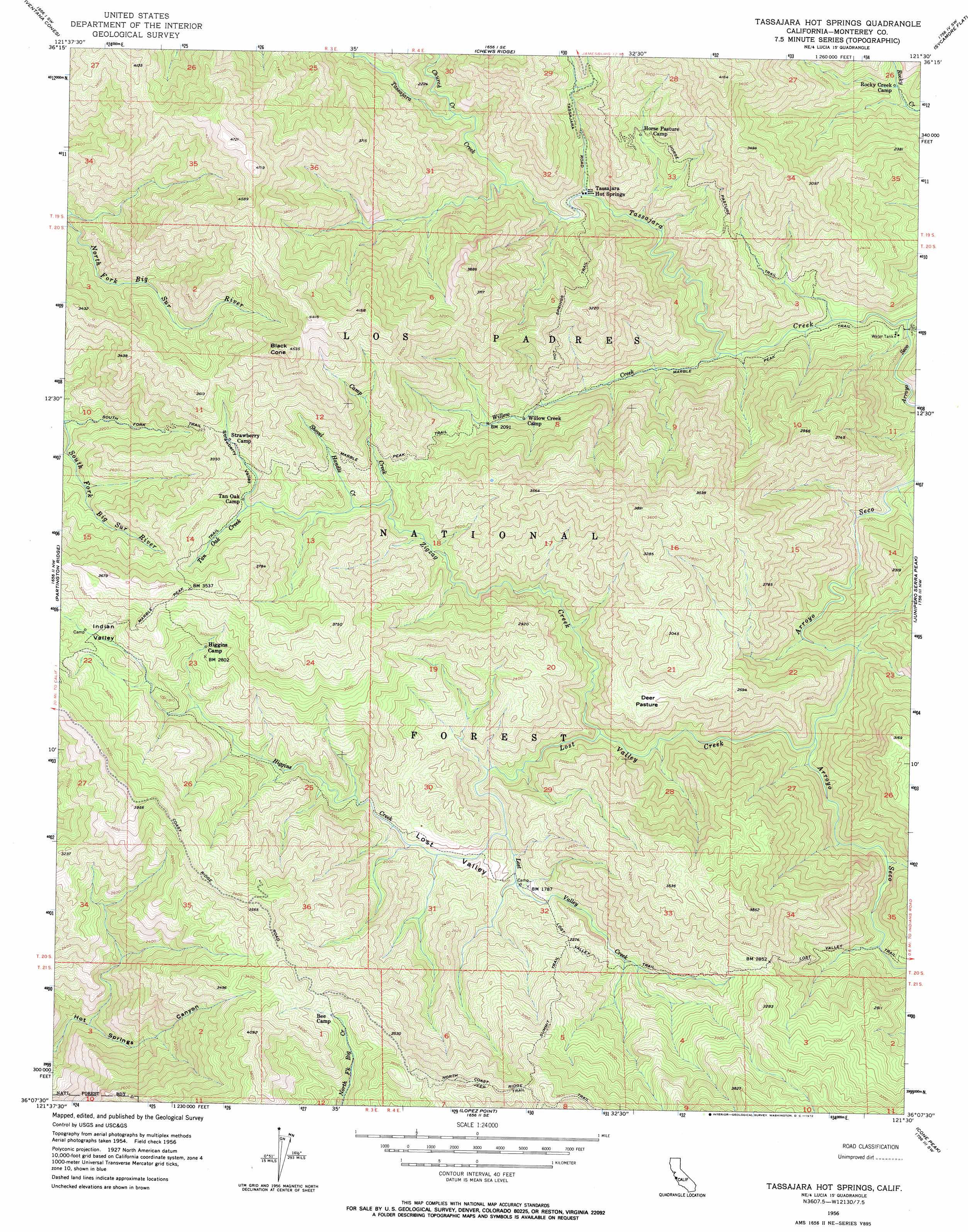
USGS Topo Quad 36121b5 - 1:24,000 scale
| Topo Map Name: | Tassajara Hot Springs |
| USGS Topo Quad ID: | 36121b5 |
| Print Size: | ca. 21 1/4" wide x 27" high |
| Southeast Coordinates: | 36.125° N latitude / 121.5° W longitude |
| Map Center Coordinates: | 36.1875° N latitude / 121.5625° W longitude |
| U.S. State: | CA |
| Filename: | o36121b5.jpg |
| Download Map JPG Image: | Tassajara Hot Springs topo map 1:24,000 scale |
| Map Type: | Topographic |
| Topo Series: | 7.5´ |
| Map Scale: | 1:24,000 |
| Source of Map Images: | United States Geological Survey (USGS) |
| Alternate Map Versions: |
Tassajara Hot Springs CA 1956, updated 1958 Download PDF Buy paper map Tassajara Hot Springs CA 1956, updated 1964 Download PDF Buy paper map Tassajara Hot Springs CA 1956, updated 1972 Download PDF Buy paper map Zigzag Creek CA 1995, updated 2000 Download PDF Buy paper map Zigzag Creek CA 2012 Download PDF Buy paper map Zigzag Creek CA 2015 Download PDF Buy paper map |
| FStopo: | US Forest Service topo Zigzag Creek is available: Download FStopo PDF Download FStopo TIF |
1:24,000 Topo Quads surrounding Tassajara Hot Springs
Mount Carmel |
Carmel Valley |
Rana Creek |
Palo Escrito Peak |
Soledad |
Big Sur |
Ventana Cones |
Chews Ridge |
Sycamore Flat |
Paraiso Springs |
Pfeiffer Point |
Partington Ridge |
Tassajara Hot Springs |
Junipero Serra Peak |
Reliz Canyon |
Lopez Point |
Cone Peak |
Bear Canyon |
||
Cape San Martin |
Alder Peak |
> Back to 36121a1 at 1:100,000 scale
> Back to 36120a1 at 1:250,000 scale
> Back to U.S. Topo Maps home
Tassajara Hot Springs topo map: Gazetteer
Tassajara Hot Springs: Areas
Horse Pasture elevation 737m 2417′Tassajara Hot Springs: Basins
Indian Valley elevation 860m 2821′Lost Valley elevation 546m 1791′
Tassajara Hot Springs: Flats
Deer Pasture elevation 672m 2204′Tassajara Hot Springs: Populated Places
Tassajara Hot Springs elevation 499m 1637′Tassajara Hot Springs: Streams
Camp Creek elevation 740m 2427′Church Creek elevation 518m 1699′
Higgins Creek elevation 517m 1696′
Lost Valley Creek elevation 399m 1309′
Shovel Handle Creek elevation 736m 2414′
Tan Oak Creek elevation 815m 2673′
Tassajara Creek elevation 293m 961′
Willow Creek elevation 348m 1141′
Zigzag Creek elevation 476m 1561′
Tassajara Hot Springs: Summits
Black Cone elevation 1363m 4471′Tassajara Hot Springs: Trails
Horse Pasture Trail elevation 694m 2276′Hot Springs Trail elevation 908m 2979′
Lost Valley Trail elevation 654m 2145′
Marble Peak Trail elevation 346m 1135′
South Fork Trail elevation 720m 2362′
Summit Trail elevation 916m 3005′
Tassajara Hot Springs: Valleys
Strawberry Valley elevation 816m 2677′Tassajara Hot Springs digital topo map on disk
Buy this Tassajara Hot Springs topo map showing relief, roads, GPS coordinates and other geographical features, as a high-resolution digital map file on DVD: