Lancaster Topo Map Virginia
To zoom in, hover over the map of Lancaster
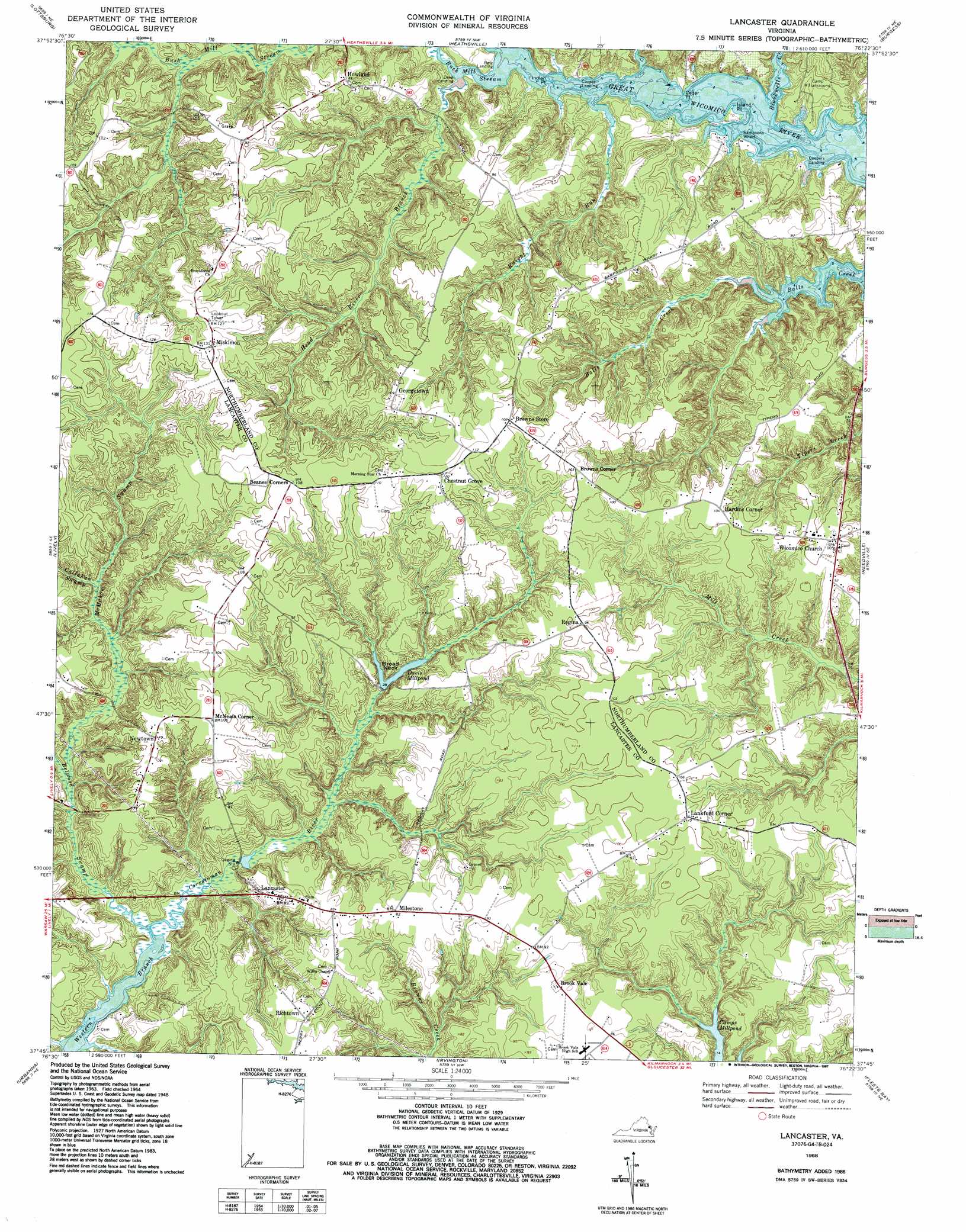
USGS Topo Quad 37076g4 - 1:24,000 scale
| Topo Map Name: | Lancaster |
| USGS Topo Quad ID: | 37076g4 |
| Print Size: | ca. 21 1/4" wide x 27" high |
| Southeast Coordinates: | 37.75° N latitude / 76.375° W longitude |
| Map Center Coordinates: | 37.8125° N latitude / 76.4375° W longitude |
| U.S. State: | VA |
| Filename: | o37076g4.jpg |
| Download Map JPG Image: | Lancaster topo map 1:24,000 scale |
| Map Type: | Topographic |
| Topo Series: | 7.5´ |
| Map Scale: | 1:24,000 |
| Source of Map Images: | United States Geological Survey (USGS) |
| Alternate Map Versions: |
Lancaster VA 1949 Download PDF Buy paper map Lancaster VA 1949 Download PDF Buy paper map Lancaster VA 1968, updated 1972 Download PDF Buy paper map Lancaster VA 1968, updated 1987 Download PDF Buy paper map Lancaster VA 1968, updated 1987 Download PDF Buy paper map Lancaster VA 2010 Download PDF Buy paper map Lancaster VA 2013 Download PDF Buy paper map Lancaster VA 2016 Download PDF Buy paper map |
1:24,000 Topo Quads surrounding Lancaster
Machodoc |
Kinsale |
Saint George Island |
Point Lookout |
East Of Point Lookout |
Haynesville |
Lottsburg |
Heathsville |
Burgess |
Smith Point |
Morattico |
Lively |
Lancaster |
Reedville |
East of Reedville |
Church View |
Urbanna |
Irvington |
Fleets Bay |
East of Fleets Bay |
Shacklefords |
Saluda |
Wilton |
Deltaville |
East Of Deltaville |
> Back to 37076e1 at 1:100,000 scale
> Back to 37076a1 at 1:250,000 scale
> Back to U.S. Topo Maps home
Lancaster topo map: Gazetteer
Lancaster: Capes
Broad Neck elevation 19m 62′Cedar Point elevation 3m 9′
Indian Point elevation 0m 0′
Island Point elevation 0m 0′
Lancaster: Dams
Twin Branch Milldam elevation 19m 62′Lancaster: Parks
Lancaster Court House Historic District elevation 25m 82′Lancaster: Populated Places
Brook Vale elevation 26m 85′Browns Corner elevation 33m 108′
Browns Store elevation 31m 101′
Chestnut Grove elevation 33m 108′
Georgetown elevation 34m 111′
Hardins Corner elevation 30m 98′
Howland elevation 25m 82′
Lancaster elevation 24m 78′
Lankford Corner elevation 34m 111′
McNeals Corner elevation 31m 101′
Milestone elevation 24m 78′
Miskimon elevation 39m 127′
Newtown elevation 33m 108′
Oak Grove elevation 30m 98′
Regina elevation 29m 95′
Richtown elevation 27m 88′
Wicomico Church elevation 30m 98′
Lancaster: Reservoirs
Davis Millpond elevation 8m 26′Twin Branch Millpond elevation 19m 62′
Lancaster: Streams
Belwood Swamp elevation 0m 0′Blackwells Creek elevation 0m 0′
Bush Mill Stream elevation 4m 13′
Callahan Swamp elevation 9m 29′
Head River Branch elevation 3m 9′
Knight Run elevation 0m 0′
McMahon Swamp elevation 1m 3′
Lancaster: Swamps
Cabin Swamp elevation 6m 19′Mount Knoddy Swamp elevation 1m 3′
White Marsh elevation 3m 9′
Lancaster digital topo map on disk
Buy this Lancaster topo map showing relief, roads, GPS coordinates and other geographical features, as a high-resolution digital map file on DVD:
Atlantic Coast (NY, NJ, PA, DE, MD, VA, NC)
Buy digital topo maps: Atlantic Coast (NY, NJ, PA, DE, MD, VA, NC)
 map DVD")