Jetersville Topo Map Virginia
To zoom in, hover over the map of Jetersville
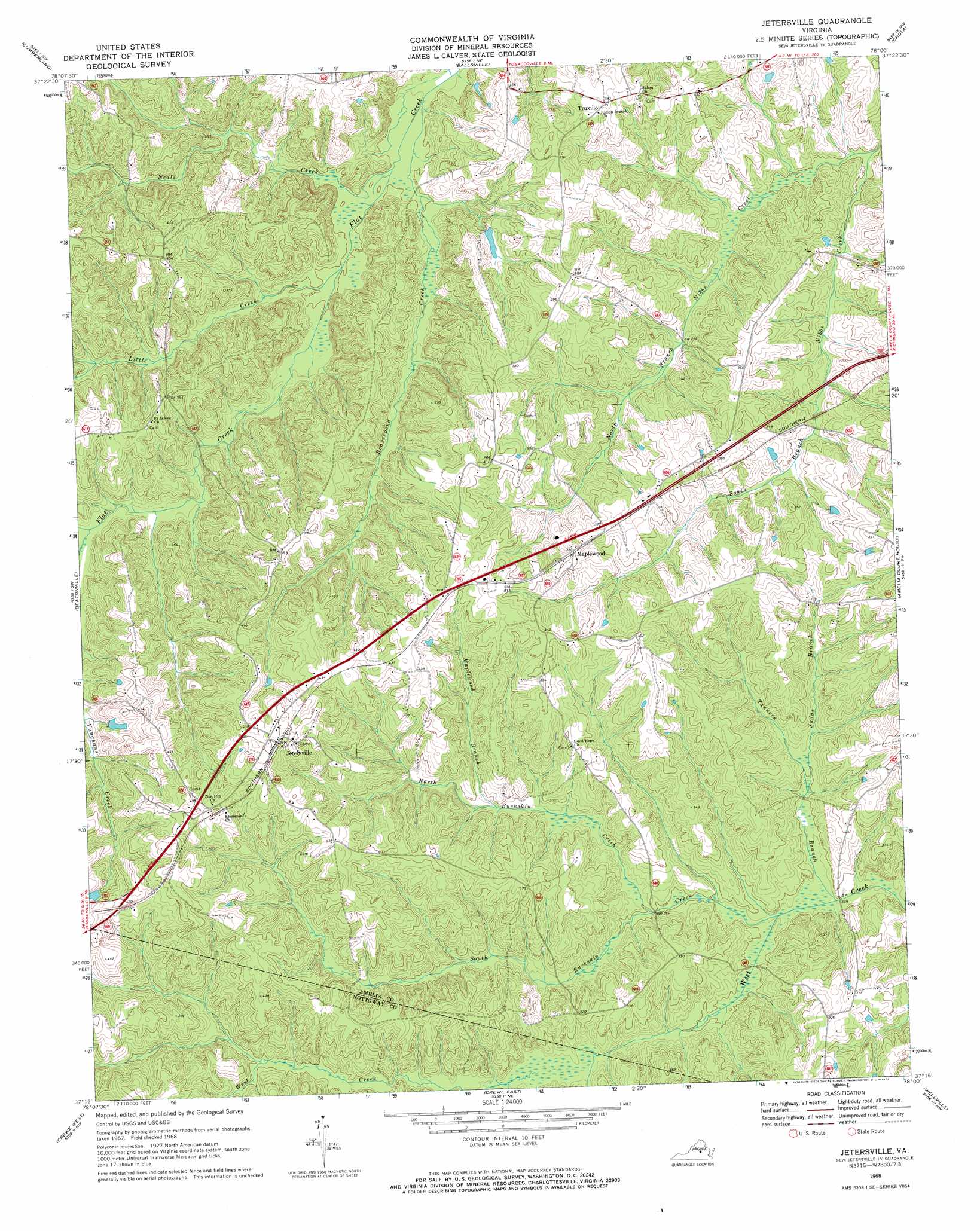
USGS Topo Quad 37078c1 - 1:24,000 scale
| Topo Map Name: | Jetersville |
| USGS Topo Quad ID: | 37078c1 |
| Print Size: | ca. 21 1/4" wide x 27" high |
| Southeast Coordinates: | 37.25° N latitude / 78° W longitude |
| Map Center Coordinates: | 37.3125° N latitude / 78.0625° W longitude |
| U.S. State: | VA |
| Filename: | o37078c1.jpg |
| Download Map JPG Image: | Jetersville topo map 1:24,000 scale |
| Map Type: | Topographic |
| Topo Series: | 7.5´ |
| Map Scale: | 1:24,000 |
| Source of Map Images: | United States Geological Survey (USGS) |
| Alternate Map Versions: |
Jetersville VA 1968, updated 1972 Download PDF Buy paper map Jetersville VA 2010 Download PDF Buy paper map Jetersville VA 2013 Download PDF Buy paper map Jetersville VA 2016 Download PDF Buy paper map |
1:24,000 Topo Quads surrounding Jetersville
Gold Hill |
Whiteville |
Trenholm |
Powhatan |
Fine Creek Mills |
Hillcrest |
Cumberland |
Ballsville |
Chula |
Clayville |
Rice |
Deatonville |
Jetersville |
Amelia Court House |
Mannboro |
Green Bay |
Crewe West |
Crewe East |
Wellville |
Hebron |
Meherrin |
Rubermont |
Blackstone West |
Blackstone East |
Darvills |
> Back to 37078a1 at 1:100,000 scale
> Back to 37078a1 at 1:250,000 scale
> Back to U.S. Topo Maps home
Jetersville topo map: Gazetteer
Jetersville: Airports
Easter Field elevation 114m 374′Jetersville: Dams
Bultje Dam elevation 94m 308′Holtes Dam elevation 99m 324′
Manns Dam elevation 107m 351′
Sanderson Dam elevation 125m 410′
Jetersville: Populated Places
Amelia Springs (historical) elevation 79m 259′Jetersville elevation 137m 449′
Maplewood elevation 120m 393′
Truxillo elevation 116m 380′
Jetersville: Streams
Beaverpond Creek elevation 73m 239′Calvary Branch elevation 81m 265′
Judds Branch elevation 76m 249′
Little Creek elevation 76m 249′
Maplewood Branch elevation 90m 295′
Neals Creek elevation 76m 249′
North Branch Nibbs Creek elevation 79m 259′
North Buckskin Creek elevation 76m 249′
South Branch Nibb Creek elevation 76m 249′
South Buckskin Creek elevation 72m 236′
Tanners Branch elevation 73m 239′
Vaughns Creek elevation 84m 275′
Jetersville digital topo map on disk
Buy this Jetersville topo map showing relief, roads, GPS coordinates and other geographical features, as a high-resolution digital map file on DVD:
Western Virginia & Southern West Virginia
Buy digital topo maps: Western Virginia & Southern West Virginia