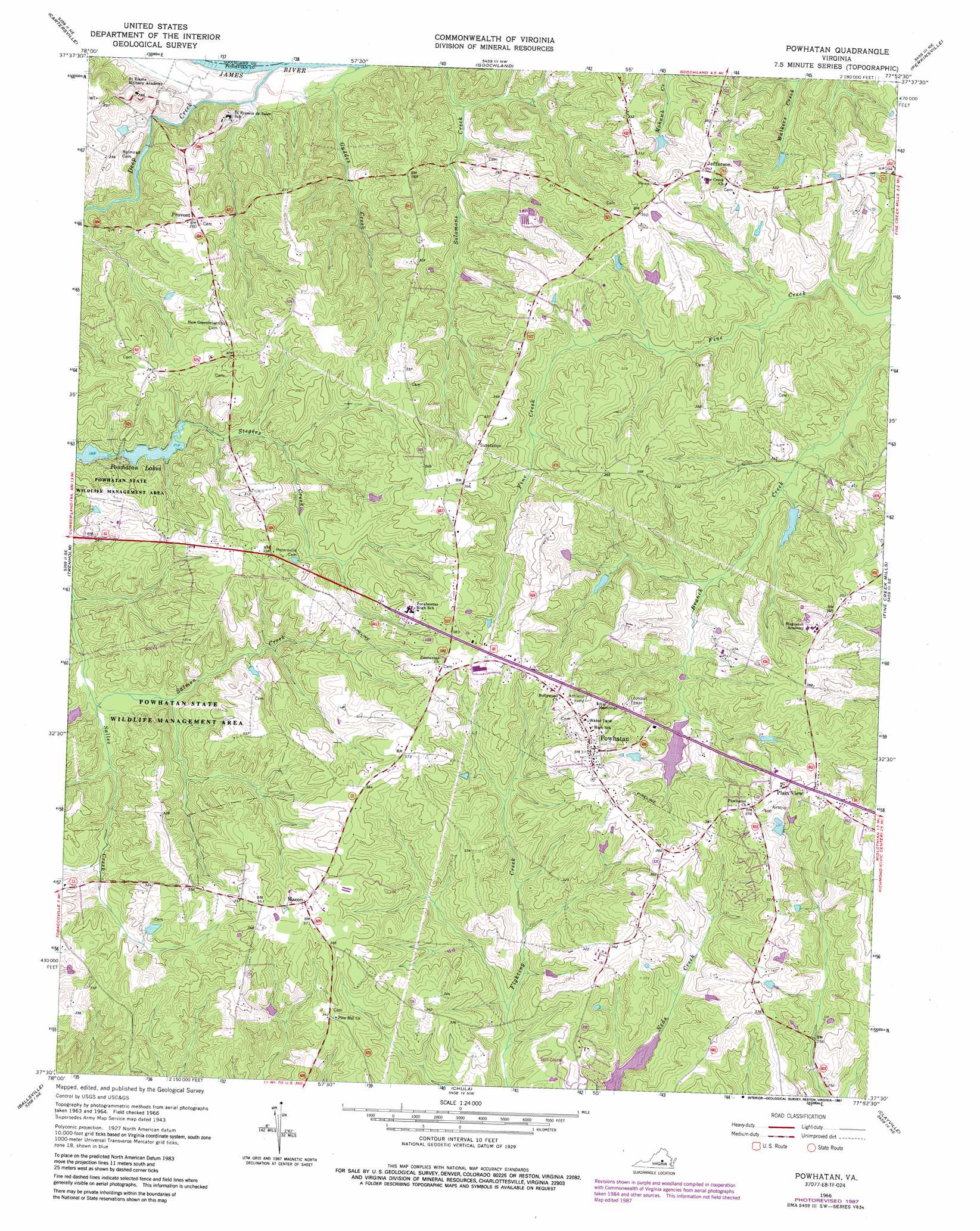
Powhatan Topo Map Virginia
To zoom in, hover over the map of Powhatan
USGS Topo Quad 37077e8 - 1:24,000 scale
| Topo Map Name: | Powhatan |
| USGS Topo Quad ID: | 37077e8 |
| Print Size: | ca. 21 1/4" wide x 27" high |
| Southeast Coordinates: | 37.5° N latitude / 77.875° W longitude |
| Map Center Coordinates: | 37.5625° N latitude / 77.9375° W longitude |
| U.S. State: | VA |
| Filename: | o37077e8.jpg |
| Download Map JPG Image: | Powhatan topo map 1:24,000 scale |
| Map Type: | Topographic |
| Topo Series: | 7.5´ |
| Map Scale: | 1:24,000 |
| Source of Map Images: | United States Geological Survey (USGS) |
| Alternate Map Versions: |
Powhatan VA 1943, updated 1961 Download PDF Buy paper map Powhatan VA 1966, updated 1968 Download PDF Buy paper map Powhatan VA 1966, updated 1977 Download PDF Buy paper map Powhatan VA 1966, updated 1987 Download PDF Buy paper map Powhatan VA 1966, updated 1987 Download PDF Buy paper map Powhatan VA 1979, updated 1982 Download PDF Buy paper map Powhatan VA 2010 Download PDF Buy paper map Powhatan VA 2013 Download PDF Buy paper map Powhatan VA 2016 Download PDF Buy paper map |
1:24,000 Topo Quads surrounding Powhatan
Columbia |
Caledonia |
South Anna |
Dabneys |
Montpelier |
Lakeside Village |
Cartersville |
Goochland |
Perkinsville |
Hylas |
Whiteville |
Trenholm |
Powhatan |
Fine Creek Mills |
Midlothian |
Cumberland |
Ballsville |
Chula |
Clayville |
Hallsboro |
Deatonville |
Jetersville |
Amelia Court House |
Mannboro |
Winterpock |
> Back to 37077e1 at 1:100,000 scale
> Back to 37076a1 at 1:250,000 scale
> Back to U.S. Topo Maps home
Powhatan topo map: Gazetteer
Powhatan: Airports
Fighting Creek Farm Airport elevation 104m 341′Plainview Airport elevation 121m 396′
Powhatan: Dams
John L Lewis Dam elevation 87m 285′Lewiss Dam elevation 87m 285′
Mill Quarter Dam elevation 74m 242′
Ransons Dam elevation 80m 262′
Tilmans Dam elevation 95m 311′
Upper Powhatan Dam elevation 70m 229′
Powhatan: Parks
Powhatan Courthouse Historic District elevation 114m 374′Powhatan State Wildlife Management Area elevation 83m 272′
Powhatan: Populated Places
Jefferson elevation 104m 341′Macon elevation 109m 357′
Plain View elevation 122m 400′
Powhatan elevation 114m 374′
Provost elevation 86m 282′
Worshams elevation 119m 390′
Powhatan: Reservoirs
John L Lewis Lake elevation 87m 285′Randolph Lake elevation 74m 242′
Sunfish Pond elevation 68m 223′
Upper Powhatan Lake elevation 70m 229′
Powhatan: Streams
Deep Creek elevation 48m 157′Gaddes Creek elevation 47m 154′
Salmon Creek elevation 64m 209′
Powhatan digital topo map on disk
Buy this Powhatan topo map showing relief, roads, GPS coordinates and other geographical features, as a high-resolution digital map file on DVD:
Atlantic Coast (NY, NJ, PA, DE, MD, VA, NC)
Buy digital topo maps: Atlantic Coast (NY, NJ, PA, DE, MD, VA, NC)
 map DVD")