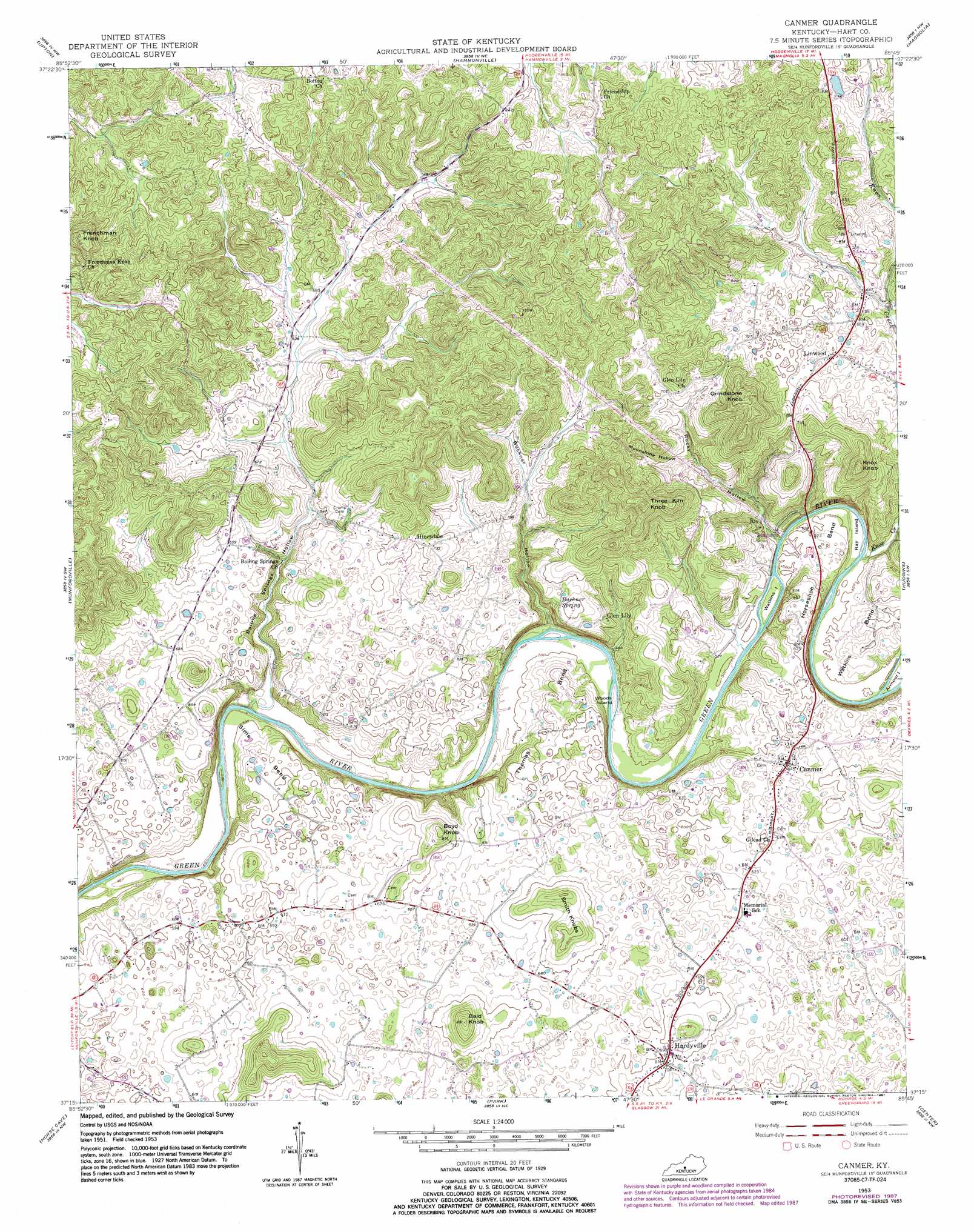
Canmer Topo Map Kentucky
To zoom in, hover over the map of Canmer
USGS Topo Quad 37085c7 - 1:24,000 scale
| Topo Map Name: | Canmer |
| USGS Topo Quad ID: | 37085c7 |
| Print Size: | ca. 21 1/4" wide x 27" high |
| Southeast Coordinates: | 37.25° N latitude / 85.75° W longitude |
| Map Center Coordinates: | 37.3125° N latitude / 85.8125° W longitude |
| U.S. State: | KY |
| Filename: | o37085c7.jpg |
| Download Map JPG Image: | Canmer topo map 1:24,000 scale |
| Map Type: | Topographic |
| Topo Series: | 7.5´ |
| Map Scale: | 1:24,000 |
| Source of Map Images: | United States Geological Survey (USGS) |
| Alternate Map Versions: |
Canmer KY 1953, updated 1955 Download PDF Buy paper map Canmer KY 1953, updated 1968 Download PDF Buy paper map Canmer KY 1953, updated 1982 Download PDF Buy paper map Canmer KY 1953, updated 1987 Download PDF Buy paper map Canmer KY 2010 Download PDF Buy paper map Canmer KY 2013 Download PDF Buy paper map Canmer KY 2016 Download PDF Buy paper map |
1:24,000 Topo Quads surrounding Canmer
Summit |
Sonora |
Tonieville |
Hodgenville |
Howardstown |
Millerstown |
Upton |
Hammonville |
Magnolia |
Hibernia |
Cub Run |
Munfordville |
Canmer |
Hudgins |
Summersville |
Mammoth Cave |
Horse Cave |
Park |
Center |
Exie |
Park City |
Glasgow North |
Hiseville |
Sulphur Well |
East Fork |
> Back to 37085a1 at 1:100,000 scale
> Back to 37084a1 at 1:250,000 scale
> Back to U.S. Topo Maps home
Canmer topo map: Gazetteer
Canmer: Bends
Horseshoe Bend elevation 158m 518′Sims Bend elevation 175m 574′
Thomas Bend elevation 190m 623′
Watkins Bend elevation 167m 547′
Canmer: Islands
Ray Island elevation 146m 479′Watkins Island elevation 146m 479′
Woods Island elevation 146m 479′
Canmer: Populated Places
Canmer elevation 194m 636′Glen Lily elevation 192m 629′
Hardyville elevation 214m 702′
Hinesdale elevation 221m 725′
Linwood elevation 208m 682′
Rio elevation 157m 515′
Canmer: Springs
Buckner Spring elevation 201m 659′Canmer: Streams
Knox Creek elevation 146m 479′Canmer: Summits
Bald Knob elevation 266m 872′Boyd Knob elevation 248m 813′
Frenchman Knob elevation 353m 1158′
Grindstone Knob elevation 324m 1062′
Knox Knob elevation 318m 1043′
Smith Knobs elevation 245m 803′
Three Kiln Knob elevation 309m 1013′
Canmer: Valleys
Boiling Springs Hollow elevation 143m 469′Buckner Hollow elevation 144m 472′
Moonshine Hollow elevation 185m 606′
Rocky Hollow elevation 144m 472′
Canmer digital topo map on disk
Buy this Canmer topo map showing relief, roads, GPS coordinates and other geographical features, as a high-resolution digital map file on DVD: